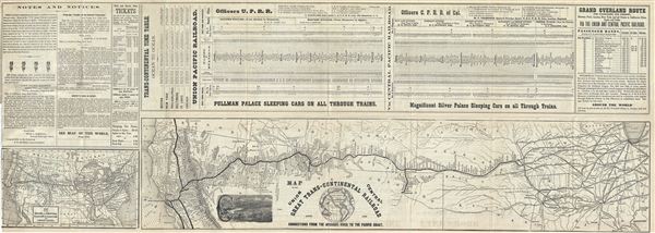
This is a fine 1871 map of the Great Trans-Continental Railroad or the Union and Central Pacific Railroad lines, showing its various connections from Missouri River to the Pacific coast. The map covers the United States from Lake Michigan to San Francisco and from Madison, Wisconsin south as far as Cairo, Illinois. It depicts the railway lines beginning with the Union Pacific Railroad line at Omaha, Iowa spanning westward to meet the Central Pacific Railroad line which span from San Francisco eastward to Utah. Both lines merged at Promontory, Utah, creating the first trans-continental railroad in North America. The Utah Central Railroad from Ogden to Salt Lake City, the Denver Pacific Railroad, the Central Pacific Railroad Oregon Division and other connections are also noted. A smaller map of the Union and Central Pacific Railway line and its connection spanning the entire United States is included in the lower left quadrant. The top portion of the sheet includes the time table and route details of both the Union and Central Pacific Railway lines. This map was issued as part of Crofutt's Trans-Continental Tourist's Guide.
Source
Crofutt, Geo. A., Crofutt's Trans-Continental Tourist Guide, (Fifth Volume) 1873.
Very good. Minor wear and verso repair along original fold lines. Lower left quadrant exhibits minor wear and verso repair. Large rip and verso and recto repair over the Notes and Notices section, not extending onto map. Map of the Union and Central Pacific Railroad Line and Connections included in the lower left quadrant.