1798 Depot de la Marine Nautical Map or Chart of Coast of Vietnam

TroisiemeCochinchine-depot-1798
$800.00
Troisieme Feuille des cotes de la Cochinchine depuis le Cap Boxhornen jusqu'au Cap Choumay. - Main View
Processing...

1798 Depot de la Marine Nautical Map or Chart of Coast of Vietnam

TroisiemeCochinchine-depot-1798

First inklings of French interest in Vietnam / Indochina.
$800.00

Title


Troisieme Feuille des cotes de la Cochinchine depuis le Cap Boxhornen jusqu'au Cap Choumay.
  1798 (dated)     28.5 x 20.5 in (72.39 x 52.07 cm)     1 : 500000

Description


This is a scarce 1798 François Étienne de Rosily-Mesros nautical chart or maritime map of the coast of modern-day central Vietnam - marking the first inkling of French political interest in Vietnam. The map depicts the coast from modern-day Qui Nhon north to Chan May near Tourane (Da Nang). A large inset in the bottom left illustrates the coast north of Cape Choumay (Chan May) and includes an elevation profile view.
The First Inkling of French Interest in Indochina
When Rosily visited the coast of Vietnam in 1778 - 1779, the country was entering an extended period of political instability. The Tây Sơn Rebellion (1771 - 1802) led to the collapse of the Cochinchine Trịnh Lords and North Vietnamese Lê dynasty (1428 - 1789). The fifteen-year-old prince of Cochinchina, Nguyễn Phúc Ánh (1762 - 1820), was forced into exile at a local mission where he befriended the French Catholic priest Pigneau de Behaine (1741 - 1799). Behaine believed he could leverage Nguyễn Ánh's desperation for supplies and troops to gain both missionary and political status - for god and king, respectively. Behaine along with Nguyễn Ánh's son, Nguyễn Phúc Cảnh (1780 - 1801), traveled to Versailles where he argued Nguyễn Ánh's cause before Louis XVI. On November 21, 1787, the Treaty of Versailles was concluded between France and Cochinchina. Four frigates, 1650 fully equipped French marines, and 250 Indian sepoys were promised in return for full cession of Pulo Condore and free access to the port of Tourane (Da Nang) - central to this map. No sooner had Behaine left for Pondicherry (and thence Cochinchina), than Louis XVI, in increasingly dire financial straits, had second thoughts, sending an advance missive to the governor in Pondicherry, Thomas Conway (1735 - c. 1800), stating that he need not provide the promised ships, troops, or supplies. Conway did nonetheless dispatch Rosily and the Méduse to survey the coast in the vicinity of Tourane / Da Nang in 1778 - resulting in this map. Although official help was ultimately not forthcoming, Behaine pressed on, raising money to finance ships and troops from merchants in Macao. With Behaine's unwavering assistance, Nguyễn Ánh eventually defeated the Tây Sơn and in 1802 became the first Emperor of Vietnam, taking the name Gia Long. Although Louis XVI, himself about to be deposed, was less than sincere in his dealings with Behaine and Nguyễn Ánh, the Nguyễn dynasty retained a positive disposition towards the French, ultimately setting the stage for colonization in the 19th century.
Meanwhile, Back in France…
Back in France, the French Revolution (1789 - 1799) deposed Louis XVI. Rosily returned to France after the most violent stages of the Revolution, likely saving his life. He was appointed head of the Dépôt des cartes et plans de la Marine, a position he continued to hold under Napoleon until 1805. He took his maps and surveys of the Vietnamese coast with him, leveraging his influence to have the Dépôt engrave and publish them in 1798 - despite a loss of relevance.
Publication History and Census
The chart was based on the observations of Vice-Admiral François Étienne de Rosily-Mesros (1748, Brest - 1832), engraved by Jean-Baptiste Croisey, and issued by the Dépôt de Marine in 1798. Three examples are cataloged in OCLC and are part of the institutional collections at the Bibliothèque Nordique in Paris, the Observatoire de Paris, and the National Library of Australia.

CartographerS


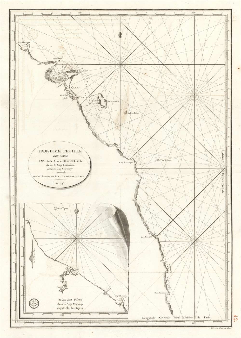
François Étienne de Rosily-Mesros (January 13, 1748 - November 12, 1832) was a French hydrographer, explorer, and naval officer active during the French Revolutionary Wars (1792 - 1802) and subsequent Napoleonic Wars (1803 - 1815). Rosily was born in Brest , the son of a prominent French naval officer. He apprenticed as a naval officer from 1762 to 1769. Reaching his independence, in 1770 he was commissioned as an enseigne de vaisseau under Yves-Joseph de Kerguelen-Trémarec (February 13, 1734 - March 3, 1797). He accompanied Kurguelen on the Third French expedition in search of Terra Australis from 1772 - 1774. In 1775 Rosily took command of Vénus and spent several years charting the coasts of east Africa, the Red Sea, the Persian Gulf, and India. In 1778, Rosily was transferred to the Pondicherry-baesd Méduse, which mapped parts of the South China Sea, including Conchinchina, the south China, and the Philippines. During the Napoleonic period, Rosily had strained relations with the emperor, who despite considering him an able naval officer, derided him for his lack of active combat service. Napoleon instead deployed him to surveying and mapping expeditions consistent with his military ambitions - including a mapping of the coast of Africa. Napoleon eventually granting Rosily a major command in Cadiz, but arriving after the British destroyed the Cadiz fleet, he was unable to fulfill his commission. Rosily was made director of the Dépôt de Marine in 1795 and retained the position until 1805. After Napoleon was deposed in 1815, the new king Louis XVIII granted him the promotion he was denied under the emperor, making him a Grand Officer of the Légion d'Honneur. In 1816, for his many scientific expeditions, he was made a free associate of the Académie des Sciences. He was also made emeritus director of the Dépôt de Marine. He died in Paris in 1832. More by this mapmaker...


Jean-Baptiste Croisey (c. 1740 - 1810) was a French Paris based engraver active from roughly 1760 through 1810. Little is known of his life and training. His earliest known work was for Jacques-Nicolas Bellin (1703 - 1772), chief Ingénieur Hydrographe at the French Dépôt des cartes et plans de la Marine until 1798. He also engraved for Louis Charles Desnos (1725 - 1805) from 1790 to 1792, and for Bruny d'Entrecasteaux in 1807, among other publishers. Learn More...


Dépôt des Cartes et Plans de la Marine (fl. 1720 - present), often called the Dépôt de Marine, was a French hydrographic mapping organization founded in 1720 under Charles-Hercule of Albert de Luynes (1674 - 1734). Much like the U.S. Coast Survey, the British Admiralty, and the Spanish Deposito Hydrografico, the Dépôt was initiated as a storehouse and distribution center of existing nautical and marine charts. Eventually the Dépôt initiated its own mapping activities in an attempt to improve and expand upon existing material. Some of the more prominent cartographers and hydrographers associated with the of Dépôt des Cartes were, Philippe Buache, Jacques-Nicholas Bellin, Giovanni Rizzi-Zannoni, Rigobert Bonne, and Jean Nicolas Buache. Learn More...

Condition


Very good. Original platemark visible. Minor spotting at places. Minor wear along original centerfold. Some offsetting. Blank on verso.

References


OCLC 835422822.