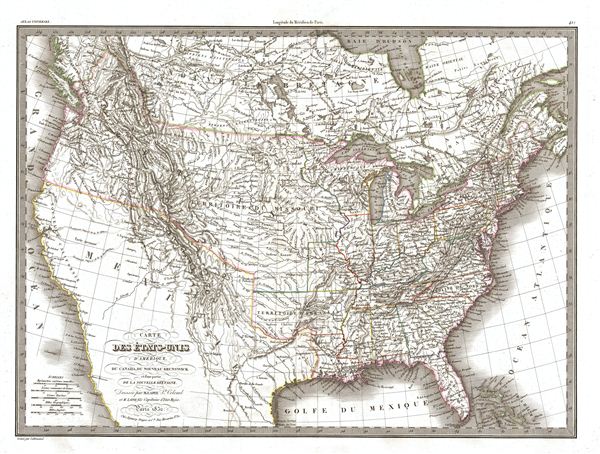
A significant though little known 1832 map of the United States, this is the first edition of M. Lapie's 1832 map of the United States. Lapie's map covers all of the territory claimed by the United States from Atlantic to Pacific and from British America (Canada) to the pre-1849 Mexican border. Beautifully illustrates the American claims in fur-rich British Columbia that led to the '54-40 or Fight' dispute between the United States and Britain. Lapie's map offers fine detail throughout with elevation rendered by hachure and political boundaries demarcated with outline hand color.
Cartographically this map is most interesting for it embracive treatment of the Trans-Mississippi region – a rarity in a map of this era. This map was issued in the waning years of the era of the Mountain Men, post Lewis and Clark fur traders who crossed the Rocky Mountains to exploit the fur riches of the Pacific Northwest. The mogul John Jacob Astor sent out one of the first expeditions to establish Fort Astoria on the Columbia River and thereby dominate the American Fur Trade. Few fur traders had the education or motivation to produce maps, but a few, such as Wilson Price Hunt, Robert Stuart, and Jedediah Smith, did make significant contributions to the cartographic corpus. Lapie must have had access to some of these early accounts, particularly Hunt's and Stuart's, which he could only have obtained from Astor himself, when he constructed his 1821 map of the Pacific Northwest on which this more inclusive later map is based.
Lapie's map generally follows the mappings of Lewis and Clark in 1814 and the 1811 explorations of the Astorian furmen Wilson Price Hunt and Robert Stuart. The 'Tour de Pompey' or Pompey's Piller (Montana) where Lewis and Clark split ways on the return journey is noted. The map ignores the explorations of Stephen Harriman Long around the Platte, Arkansas and Red River basins as well as the discoveries of Jedediah Smith beyond the Great Basin. The Great Basin itself exhibits cartography reminiscent of the escalante expedition with Great Salt Lake (L. Timpanagos) and Utah Lake (L. Teguayo) connecting to the Pacific via the speculative rivers Millers and Buenaventura. Lapie indicates the Santa Fe Trail from St. Louis to Santa Fe. No trace of the Sierra Nevada range is in evidence.
This map was engraved by Armand Joseph Lallemand as plate no. 43 in the first edition of M. Lapie's important Atlas Universel. This map, like all maps from the Atlas Universel features an embossed stamp from the Lapie firm.
CartographerS
Pierre M. Lapie (fl. 1779 - 1850) and his son Alexandre Emile Lapie (fl. 1809 - 1850) were French cartographers and engravers active in the early part of the 19th century. The Lapies were commissioned officers in the French army holding the ranks of Colonel and Capitan, respectively. Alexander enjoyed the title of "First Geographer to the King", and this title appears on several of his atlases. Both father and son were exceptional engravers and fastidious cartographers. Working separately and jointly they published four important atlases, an 1811 Atlas of the French Empire (Alexander), the 1812 Atlas Classique et Universel (Pierre), the Atlas Universel de Geographie Ancienne et Modern (joint issue), and the 1848 Atlas Militaire (Alexander). They also issued many smaller maps and independent issues. All of these are products of exceptional beauty and detail. Despite producing many beautiful maps and atlases, the work of the Lapie family remains largely underappreciated by most modern collectors and map historians. The later 19th century cartographer A. H. Dufour claimed to be a student of Lapie, though it is unclear if he was referring to the father or the son. The work of the Lapie firm, with its precise engraving and informational density, strongly influenced the mid-19th century German commercial map publishers whose maps would eventually dominate the continental market. More by this mapmaker...
Armand Joseph Lallemand (c. 1810 - 1871) was an engraver and map publisher based in Paris during the mid-19th century. Most of Lallemand's work focused on landscapes and building vies, though he did take part in a few cartographic ventures, including the production of an atlas with Alexandre Emile Lapie and several tourist pocket maps of Paris. Learn More...
Source
Lapie, M., Atlas Universel de Geographie. Ancienne et Moderne, precede d'un Abrege de Geographic Physique et Historique…, 1829. (Rumsey identifies this as the first edition of Lapie's Atlas Universel. In all known examples, the title page is dated 1829 while the maps are dated variously to 1833 - suggesting that the first issue of this atlas was 1833, not 1829.)
Very good. Original platemark visible. Blank on verso. Original centerfold.
Rumsey 2174.043. Phillips (Atlases) 754, 765. Wheat, C. I., Mapping of the Transmississippi West, 1540 – 1861, 5 vols, #428 (1837 edition).