Title
United States of America.
1829 (dated)
46 x 60 in (116.84 x 152.4 cm)
1 : 2000000
Description
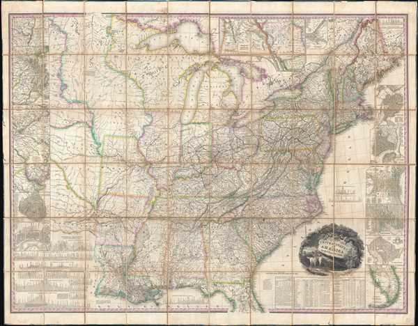
This, the first edition of Henry Schenck Tanner's 1829 wall map of the United States, is one of the most important American maps of the 19th century. The map covers from the Missouri river in the vicinity of Fort Mandan eastward to the Atlantic seaboard and from the Great Lakes to the delta of the Mississippi. South Florida is included via an inset appearing on the lower right quadrant. The Pacific Northwest, including Oregon, as well as modern day Idaho, Washington, Montana, and Wyoming, are continued in an inset at the top center, just above Lake Huron.
Tanner identifies various American Indian nations as 'districts', particularly in the Trans-Mississippi region. These include the Huron, Sioux District, Mandan District, Osage District and Ozark District, among others. He also includes all major roadways as well as distance measurements between towns - a useful detail which the accompanying memoir notes caused the map to take twice as long to prepare.
The whole is surrounded by 14 inset maps detailed various American cities. These include the Environs of Albany, Environs of Boston, Environs of New York, Environs of Philadelphia and Trenton, Environs of Baltimore and Washington, Cincinnati, Charleston, New Orleans, Washington, Baltimore, Philadelphia, New York, Boston, Pittsburg and Environs, as well and regional maps detailing south Florida, Oregon and Mandan.
This last inset, 'Oregon and Mandan' is particularly significant as the first appearance of that name on a map. There is a secondary sub-inset within this larger map entitled 'Outlet of the Oregon River'. In this case, the Oregon is the modern day 'Columbia River'.
With this important map Tanner initiated a new age of quintessentially American cartography. Unlike his predecessors, Melish and Carey, Tanner was born and raised in the United States. His maps are stylistically unique, providing a wealth of information with fine highly detailed engraving.
We offer this map accompanied by both the first and second editions of Tanner's fascinating Memoir on the Recent Surveys, Observations, and Internal Improvements in the United States in which he expounds upon the process of producing this remarkable map.
Tanner engraved this map with assistance by E.B. Dawson, and W. Allen. The title cartouche, which pictures a country landscape with two deer in the foreground, was engraved by J.W. Steel. Tanner's map proved both useful and popular, with several editions to follow. Rumsey notes edition sin 1829 (present example), 1830, 1832, 1834, 1836, 1838, 1839, 1841, 1843, and 1850. Although he does not offer references to this, it is likely that Tanner derived some of the basic cartography from J. and A. Walker's map of the United States which was published in London two year prior. Regardless, this was the premier map of the United States until superseded by Mitchell's map of 1834.
Cartographer
Henry Schenck Tanner (1786 - May 18, 1858) was one of the preeminent American map engravers and publishers of the early 19th century - what is considered to be the "Golden Age of American Map Publishing". Born in New York City but based in Philadelphia, Tanner's forty plus year career was almost entirely focused on cartographic work. His earliest map work appears in conjunction with another important map publisher, John Melish. Early in his career, Tanner partnered with his brother Benjamin, to engrave extensively for Melish as well as other Philadelphia publishers including Lucas Fielding (Baltimore), A. Bourne, Jason Torey, Samuel Harrison, and Samuel Lewis, among others. In 1818 Tanner convinced his fellow publishers and partners to finance the compilation of a New American Atlas. The atlas was sold by subscription and slowly emerged between 1819 and 1823. The New American Atlas, possibly the pinnacle of 19th century American cartography and was commended in its day as "one of the most splendid works of the kind ever executed in this country". It was subsequently republished in several updated editions until about 1839. Tanner had by this time become the most active and influential map publisher in the United States. Around 1832, recognizing the market for a less cost prohibitive atlas, Tanner began work on the smaller format New Universal Atlas. This popular and important atlas went through numerous editions before being bought out by Carey and Hart, and then, in 1846, by S. A. Mitchell, who would rise to become the preeminent publisher of the next generation. In addition to these important atlases, Tanner also issued numerous extremely important and influential travelers guides, state maps, wall maps, and pocket maps. He should not be confused with his brother, also an America map engraver, the New Yorker Benjamin Tanner. More by this mapmaker...
Condition
Very good. Dissected and mounted on linen by publisher. Accompanied by original red lether binder and two volumes of related text.
References
Rumsey 0975.001 . Phillips (America) page 885. Howes T28. Ristow, W., American Maps and Mapmakers, p. 198. American Imprints (1829) 40603; Phillips, America, p. 885; Rumsey 975; Streeter Sale 3835. Mapping the Transmississippi West II, #390, p. 94 (illustrated), p. 96. Boston Public Library, Leventhal Collection, G3700 1829 .T3. Schwartz & Ehrenberg, The Mapping of America, p. 253