Title
大觀世界大地圖 / Dàguān shìjiè dà dìtú. / Grand World Map.
1945 (dated)
58 x 124 in (147.32 x 314.96 cm)
1 : 14800000
Description
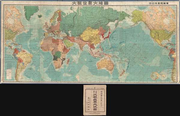
A truly monumental 1945 World War II Era Japanese world map with its original slipcase. This map is enormous, measuring roughly 10 feet x 5 feet, or 3.15 x 1.5 meters. It is centered on the Dai Nippon Teikoku, or Greater Japanese Empire, which is highlighted in dark red and includes Japan, Korea, Taiwan, part of Sakhalin, and the Japanese Kurile Islands. The map covers the entire world, except the polar regions, with the Americas appearing twice, at either extreme of the page (reflective, possibly, of the United States as a dual power, both in the Atlantic and the Pacific). Shading in blues illustrates oceanic depths and arrows show the flow of ocean currents. Concentric rings, in red, illustrate distances from Japan.
Some of the color-coding on the map is of exceptional interest, particularly in the Pacific, where the state of the war is uniquely expressed. Areas firmly a part of the Dai Nippon Teikoku, including Korea, Taiwan, and southern Sakhalin, are bright red. Puppet states, or at least regions the Japanese imagined might be so, including Burma, Manchuria, and Philippines appear in a lighter red. Allies to Japan, specifically Thailand, appear in a darker red. Curiously, Indonesia, the Malay States (Malaysia), and parts of New Guinea, as well as parts of Micronesia, are bordered in red, possibly indicating that they were theoretically controlled by the Empire of Japan, but by January 1945 no longer under Japanese hegemony. Inner Mongolia, in 1945 also a puppet state of Japan, is highlighted in red. Beyond Asia, the color coding seems more random and less informative. There appears to be some connection to colonial activity, with for example Italy and Libya are of the same tone. So too are France, French Indochina, and French west Africa.
The map is stylistically akin the 20-map series Greater East Asian Co-Prosperity Sphere which was issued a few years earlier in 1942 and 1943. Both maps have the same color scheme, use identical typefaces, and employ blue shading to illustrate oceanic depths. Both this map and the Co-Prosperity Sphere series were published by the Japan Publishing and Distribution Company, Ltd. (日本出版配給株式會社).
This map was printed on January 20 of 1945 and is the largest Japanese map of the world issued before the end of World War II. Text on the map suggests that the printing was limited to 2000 copies. No other surviving examples are known.
Condition
Very good. Some wear on original fold lines. Verso repairs of a few minor tears at fold intersections. Folds into original slipcase.