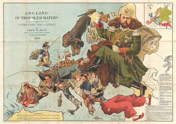
One of Frederick W. Rose's most iconic caricature or satirical maps, this is the 1899
Angling in Troubled Waters. The map presupposes that the reader will recognize the familiar shape of Europe and its constituent nations, which have here been replaced by caricatures, each of which tell their own political story. In
Angling in Troubled Waters Rose uses an effective 'fishing' metaphor to illustrate conflicts associated with Europe's crumbling global colonial hegemony as well as inter-European political tensions.
The map is rich in detail and there is far more going on than can be easily addressed here, but here is a recap of the major issues presented:
- England is represented by John Bull, who, with a rich colonial catch in Ireland and an excellent store of bait, can most likely anticipate greater colonial expansion. Egypt, in the form of a crocodile, dangles on a hook in the Red Sea - suggesting that England may have hooked dangerous prey.
- France presents an internal struggle between civil and military power as symbolized by the 1898 Dreyffus Affair. This struggle also puts French colonial interest in Panama at risk. French enterprises in Africa are illustrated by a fish named 'Fashoda' that has slipped the hook. This is a reference the 1898 Fashoda Incident in which the French unsuccessfully attempted to seize control of the White Nile and thereby prevent British expansion into Mahdist Sudan.
- Spain looks on dejectedly westward having lost Porto Rico, Cuba, and the Philippines to the United States in the 1898 Treaty of Paris. At the same time, Don Carlos lurks behind, prepared to steal the crown.
- Portugal prepares to sells its colony in the Mozambique for considerable profit.
- The German Kaiser seems to have turned his attentions to commerce and industry.
- Italy is depressed by its massive debt but still manages to hold colonies in East Africa, including Eritrea and Somalia.
- Serbia and Romania are represented as children.
- Norway and Sweden are canines engaged in rough play which notably has the potential to turn into serious conflict.
- Russia, represented by Tsar Nicholas II, occupying much of the map, holds out an olive branch of peace, but we cannot miss the stockpiling of arms in nearby Finland and the sword and muskets kept at ready. His fishing line notably extends eastward toward China, a Dragon.
- Turkey occupies the lower right quadrant and represents a figure much diminished. Skulls in Armenia and Bulgaria, reference national atrocities. Still he holds on the Create and listens carefully to the situation in Europe.
This chromolithograph serip-comic map as drawn by Matt Hewerdine after designs by Fred W. Rose. It is one of Rose's most iconic maps and is highly sought after by collectors.
CartographerS
Frederic William Rose (November 12, 1849 - January 3, 1915) was a politically conservative British satirist and caricature artist active in the late 19th century. There has been considerable debate regarding Rose's actual identity, due not to any attempt at secrecy, but rather at the commonality of the name. Nonetheless, recently book dealers Laurence Worms and Roderick Barron unearthed a great deal of new information about Rose and, apparently, we can anticipate an upcoming book. According to Worms, Rose was born to a well to do Paddington family of Scottish descent, the son of Major Hugo Monroe St. Vincent Rose of Glastullich and Frances Walrond Roberts. He was appointed as a clerk in the Legacy Duty office at Somerset House - where he was employed, in various positions, for the remainder of his working days. Rose married Catherine Rose Gilchrist and moved to London, where the Rose family lived at 9 Kensington Crescent before, in 1873, relocating to 4 Cromwell Crescent, where they remained. Rose traveled extensively throughout Europe and in 1885 published Notes on a Tour in Spain. In 1891 he divorced his wife on the grounds that she committed adultery - a rather humiliating and uncommon claim at the time. He wrote several other books and subsequently lost two of his sons in World War I. He died in London in 1915. In cartographic circles, Rose is best known for popularizing the caricature map in Europe. His most famous and influential work, while copied from Dutchman J. J. Van Brederode, is the 'Serio-Comic War Map', which represents late 18th century Russia as a grasping Octopus. Nonetheless, he also issued several other maps including another map of Europe entitled 'Angling in Troubled Waters' and variant of the Octopus map entitled 'John Bull and his Friends'. A less well known Rose map focuses on the British Isles and satirizes the 1880 Gladstone Government. More by this mapmaker...
George Washington Bacon (1830 - 1922) was a London based book and map publisher active in the mid to late 19th century. Bacon's firm G.W. Bacon and Co. purchased the plates created by Edward Weller for the Weekly Dispatch Atlas then modified and updated them for several of their own important atlases, including The New Ordnance Atlas of the British Isles. In 1893, Bacon & Co. acquired the map publishing business of J. Wyld. Then, around the turn of the century, Bacon & Co. itself was folded into the Scottish publishing house of W.& A.K. Johnston. Learn More...
Good. Like most examples of this map there is considerable wear and splitting on the original fold lines - see zoom feature. The whole has been backed with archival tissue. Accompanied by original binder, which is worn at edges and repaired along fold. Some loss and damage over title.
OCLC 54631842, 186946241, 232038387. Hill, G., Cartographical Curiosities, p. 46-49 R.V. Tooley, Geographical Oddities (London 1963 Map Collectors' Series 1), nr. 84.