This copy is copyright protected.
Copyright © 2024 Geographicus Rare Antique Maps
1854 Hidrografica Nautical Chart of Map of Cuba
CubaWest-hydrografica-1837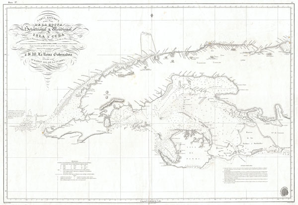

The Direccion Hidrografía (1787 - 1927), also known as the Deposito Hydrografico and the Direction de Hidrografía, was the Spanish equivalent of the British Admiralty or the U.S. Coast Survey. This organization, founded in 1787, was commissioned to collect and produce accurate nautical charts of all waters frequented by Spanish vessels. In essence, it replaced the Casa de la Contratación de las Indias (House of Trade of the Indies), which closed its doors in 1790. Like most such organizations, the Direccion Hidrografía marked a new age in cartography. Rather than simply collect charts created by navigators, explorers, and merchants, the Direccion Hidrografía worked closely with naval and military personnel to mount cartographic and hydrographic expeditions in pursuit of the most accurate hydrographical, astronomical, and geodetic measurements. The Direccion Hidrografía created a massive library of nautical charts that, though not nearly as common as similar nautical charts by the U.S. Coast Survey and British Admiralty, are highly desirable for the beauty of their manufacture as well as their accuracy and detail. The office was originally located on Calle Ballesta, but relocated to 36 Alcala, both in Madrid. After 1908 the Dirección was subsumed into other governmental agencies. In 1927 the Direccion was absorbed into the Institute and Observatory of San Fernando, located in Cadiz. The library of original maps, charts, and journals was transferred to the Naval Museum of Madrid - where it resides to this day. More by this mapmaker...
Ramon Gil de Cuadra (1775 - 1860) was a Spanish scientist and politician active in the early 19th century. Gil de Cuadra traveled extensively throughout the world including documented voyages to North America, South America, the Philippines and British India. He was part of the Spanish embassy to the United States to define the limits to Spanish possessions in the New World. Later, Cuadra is known to have lived for a time in England before returning to Spain in 1836 to accept a commission as the minister of the Interior-Portfolio Direccion Hidrografico. He also served as a Royally appointed Senator-for-life, Director of the Navy, and Minister of the Interior of the Peninsula. Learn More...
Angel Laborde y Navarro (August 2, 1772 - April 4, 1834) was a Spanish Marine and Naval Commander active in the early part of the 19th century. Navarro had a loud and distinguished military career and was active in numerous naval campaigns, most of which were in the Caribbean. Navarro established a reputation as a cleaver tactician and strategist able to find a path to victory in even the most dire circumstances. In 1832, near the end of his days, he was appointed Minister of Marine by Royal Decree. Though he maintained the position for only two years, he instigated a number of important surveys and wrote a book on naval combat. In 1833, for his accomplishments, he was awarded the Cruz de Isabel la Catolica, a high military honor. Navarro died in Havana, Cuba, in 1834. Learn More...
Copyright © 2024 Geographicus Rare Antique Maps | Geographicus Rare Antique Maps
This copy is copyright protected.
Copyright © 2024 Geographicus Rare Antique Maps