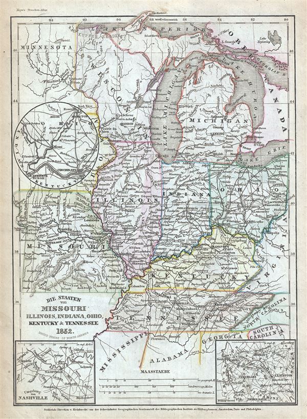
This is a fine example of Joseph Meyer's 1852 map of the American Midwest. It covers the states of Missouri, Illinois, Indiana, Ohio, Michigan, Wisconsin, Kentucky and Tennessee as well as parts of Minnesota. Three inset maps are also included, detailing Nashville and vicinity, Franklin and vicinity and Cincinnati and vicinity. The map notes several towns, rivers, railway, roads and other topographical features. Great Lakes are well represented with Lake Michigan and Lake Superior appearing in full, while Lake Erie and Lake Superior are depicted only partially.
This map was issued at the height of the American westward expansion. A few years before this map was drawn the California gold discovery of 1849 enticed thousands to embark upon the rigorous transcontinental emigration. Meanwhile, with the rise in territorial population to the west of the Mississippi, the eastern states were becoming increasingly divided over the issues of slavery and state vs. federal sovereignty. Within five years these disputes would lead to the American Civil War. The Missouri Compromise which allowed Missouri to become a slave state stipulated that no future state north of Missouri's southern border could enter the Union as a slave state. Though the Compromise briefly alleviated north-south tensions, it would only last until 1854 when the Kansas-Nebraska Act nullified the Missouri Compromise, setting the stage for the Civil War. Because it was centrally located, Ohio was strategically important to the war efforts of both the Union and Confederacy. The Ohio River and its attendant railroads were vital for the movement of troops and supplies. Indiana, which sided with the Union, was the first state to mobilize for the war effort and its soldiers were present in all major battles. Although many major Civil War battles were fought in Tennessee, Kentucky officially remained 'neutral' throughout the war.
This map was issued in Meyer's Zeitung Atlas. Although all the maps in this atlas are not individually dated, the title page and maps were often updated while the imprint with the date was not, causing confusion to the exact date for some of the maps. Moreover some maps in the atlas were taped in at a later date as an update to the atlas. We have dated the maps in this collection to the best of our ability.
Cartographer
Joseph Meyer (May 9, 1796 - June 27, 1856) was a German industrialist and publisher, most notably for the encyclopedia Meyers Conversation-Lexicon. Born in Gotha, Germany, Meyer was educated as a merchant in Frankfurt am Main. He moved to London in 1816, but returned to Germany in a820 after his stock speculations and business adventures fell through. Once back in Germany, he began by investing in the textile trade (1820-24). Meyer began creating business plans concerning how to start railways soon after the first steam-hauled railway began operation in December 1835. He founded the Deutsche Eisenbahnschienen-Compangie auf Actien (German Railway Rail joint stock company) in 1845. Meyer also found great success as a publisher, utilizing the system of serial subscriptions to publications, a new idea for the time. He founded a company, Bibliographisches Institut in Gotha in 1825, which published several versions of the Bible, works of classical literature, atlases, the world in pictures on steel engravings, and an encyclopedia. More by this mapmaker...
Source
Meyer, J., Meyer's Zeitung Atlas, 1852.
Meyer's Zeitung Atlas, formally titled Neuster Zeitungs-Atlas Fuer Alte und Neue Erdkunde was a popular German hand-atlas published in Heidelberg by Joseph Meyer between, roughly, 1848 and 1859. The atlas is well engraved in the German style with exceptionally dense detail and minimal decoration. Meyer's Atlas, and its constituent maps, are typically very difficult to date as later editions often contain earlier maps and earlier editions later paste-in updates. That said, the atlas' frequent updates and publication run during a turbulent decade provide a noteworthy cartographic record of the period.
Very good. Minor overall toning and some foxing at places.