This copy is copyright protected.
Copyright © 2024 Geographicus Rare Antique Maps
1797 Laurie and Whittle Nautical Map of the West Coast of Sumatra, Indonesia
SumatraWest-lauriewhittle-1797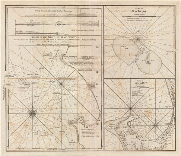

Laurie and Whittle (fl. 1794 - 1858) were London, England, based map and atlas publishers active in the late 18th and early 19th century. Generally considered to be the successors to the Robert Sayer firm, Laurie and Whittle was founded by Robert Laurie (c. 1755 - 1836) and James Whittle (1757-1818). Robert Laurie was a skilled mezzotint engraver and is known to have worked with Robert Sayer on numerous projects. James Whittle was a well-known London socialite and print seller whose Fleet Street shop was a popular haunt for intellectual luminaries. The partnership began taking over the general management of Sayer's firm around 1787; however, they did not alter the Sayer imprint until after Sayer's death in 1794. Apparently Laurie did most of the work in managing the firm and hence his name appeared first in the "Laurie and Whittle" imprint. Together Laurie and Whittle published numerous maps and atlases, often bringing in other important cartographers of the day, including Kitchin, Faden, Jefferys and others to update and modify their existing Sayer plates. Robert Laurie retired in 1812, leaving the day to day management of the firm to his son, Richard Holmes Laurie (1777 - 1858). Under R. H. Laurie and James Whittle, the firm renamed itself "Whittle and Laurie". Whittle himself died six years later in 1818, and thereafter the firm continued under the imprint of "R. H. Laurie". After R. H. Laurie's death the publishing house and its printing stock came under control of Alexander George Findlay, who had long been associated with Laurie and Whittle. Since, Laurie and Whittle has passed through numerous permeations, with part of the firm still extant as an English publisher of maritime or nautical charts, 'Imray, Laurie, Norie and Wilson Ltd.' The firm remains the oldest surviving chart publisher in Europe. More by this mapmaker...
Joseph Huddart (1741 - 1816) was a British navigator, sea captain, hydrographer, and businessman active in the late 18th and early 19th centuries. Huddart was born in Allonby, Cumberland, England. His father was a tradesman who became part owner of a local fishery and herring processing company. Showing an early affinity for mathematics and mechanics Huddart trained as a sea captain along the Irish coast. Later he designed and built his own ship, the Patience with which he traded his father herring as far as the West Indies. In 1771 Sir Richard Hotham, a family friend and distant relative introduced Huddart to the East India Company. Huddart completed four voyages to the East Indies where he surveyed the coasts from India to Sumatra. Much of his work found its way into various published nautical charts issued in the late 18th and early 19th centuries. Huddart retired from sailing around 1790. Afterwards he completed a navigational guide to China and New Holland which earned him a place in the Royal Society. Also, while residing in London Huddart devised a technique to improve the tensile strength of marine rope using an automated steam powered process. The processes earned an extraordinary fortune with which he acquired several estates in London and Wales. Huddart died at Highbury Terrance, London in 1816. He was 76 years old and survived by five sons. Learn More...
Copyright © 2024 Geographicus Rare Antique Maps | Geographicus Rare Antique Maps
This copy is copyright protected.
Copyright © 2024 Geographicus Rare Antique Maps