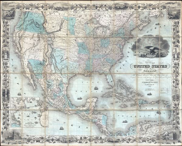
An exceptionally beautiful map of considerable historic importance, this is J. H. Colton's first edition 1849 map of the United States on the cusp of the California Gold Rush. Colton depicts the borders of the United States as consolidated under the 1848 Treaty of Guadeloupe Hidalgo signed at the end of the Mexican American War. The United States stretches from coast to coast with the Mexican Cession of Upper California or New California noted. Texas is rendered at its fullest extent as a state with its 1845 - 1849 borders, including the stovepipe northern panhandle. Alternative Texas borders and claims within the new state are also noted. Nebraska too is illustrated at its fullest extent reaching northwards as far as the Canadian border. Cartography in California remains primitive but the Gold Region on the Sacramento River around the town of New Helvetia, the original name of John Sutter's settlement, are noted.
Possibly this map's most interesting feature is its thorough presentation of Texas - a topic no doubt much on the minds of Colton's educated American clientele. The map not only illustrates the borders under which Texas joined the Union in 1845, but also various alternative and conflicting borders actively debated during the Mexican American War until their ultimate resolution in the Compromise of 1850. These include highlights in blue showing Mexican claims as far northeast as the Nunces River - a major catalyst of the Mexican American War. Those who argued for a border at the Nunces River also argued that the border should continue north along the Guadeloupe Mountains roughly to the Red River Valley. Still other borders recognize old Mexican distinctions relating to the governance of Santa Fe. These were eventually resolved by the Treaty of Guadeloupe-Hidalgo in 1848 and the subsequent Compromise of 1850 which firmly fixed the borders of Texas much as they are today.
The United States' other new acquisition, Upper California, is presented in a primitive form predating substantive updates derived from Fremont's explorations. Sacramento still appears as New Helvetia, the name John Sutter gave to his Mexican grant before discovering gold in the region. The cartography along the Sacramento River and its tributaries remains vague and incomplete, a fact which would soon change as explorers and gold prospectors flooded into the region. In the Great Basin little is known. The second edition updates this region considerably adding Fremont's Route along the Humboldt River and several new mountain ranges.
One subject of some interest in this region is a note at the convergence of the Colorado and St. John's River that reads 'Supposed Residence of the Aztecs in the 12th century.' This references the German naturalist Alexander von Humboldt's analysis of codices and other indigenous legends regarding the 12th century Aztec migration into the Mexico valley from somewhere far to the north. Also noted in modern day New Mexico, but what was is here Texas are the Ruins of Gran Quivira. These extensive Anasazi ruins were plundered by Coronado and settled by Spanish missionaries in the 16th century. They are often associated with legends of the apocryphal Seven Cities of Gold sought by many early conquistadors.
Colton has also noted several routes related to the American Westward Migration. These include the Oregon Trail, with distances noting from Westport Landing, Missouri. The Santa Fe Route, also running from Westport Landing, appears further south. In addition to migrant routes, the map also details military routes, including those taken by General Kearney in 1846, John C. Fremont, and General Wool, among others. Throughout indigenous American Indian Nations are meticulously noted.
An inset has been added to the lower left quadrant detailing the Atlantic Ocean and several trans-Atlantic shipping routes. These include the New York - Boston - Halifax - Liverpool route. Various other routes run from the Havana to Madeira and spider-web throughout the West Indies. No fewer than 15 decorative ships, including both tall ships and steam vessels, decorate the seas. The dramatic cartouche image includes a large Bald Eagle sitting astride a stars and stripes armorial shield and various trade goods. A bustling port scene appears in the background.
The map is highly decorative and evocative of John M. Atwood's personal style. Although Atwood himself engraved only the map proper, with the border design and pictorial engraving being the work of W. S. Barnard, the whole is so indicative of Atwood's style we can only image that he supervised the full engraving process. The map is surrounded by an elaborate grape vine border with numerous pictorial vignettes. The four primary vignettes illustrate, clockwise from top left: salmon fishing at Willamette Falls, Oregon; the valley of the Connecticut River as seen from Mount Holyoke; the Capitol Building, as yet incomplete, in Washington D.C.; and the cathedral of Mexico City. Lesser vignettes at the top and bottom of the map illustrate John Jacob Astor's fur trading outpost in Astoria, Oregon; Lake Saratoga in New York; Mexican's catching wild cattle; and ships entering a port. To the right and left of the map are illustrations of the Pulaski Monument in Savanna, Georgia; the Battle Monument of Baltimore, Maryland; the Bunker Hill Monument in Boston, Massachusetts; and the Washington Monument in New York City, New York (no longer extant?).
Two editions of this map were issued in 1849, the present example being the first. The first edition generally appeared as thus, dissected and mounted on linen (its most desirable format), or mounted and canvass with rollers as a wall map. The second edition, issued later in 1849 in anticipation of the Compromise of 1850 shows Texas with more restrained borders as well as updates relating to the explorations of Fremont and the discovery of Gold at Sutter's Mill. The second edition typically appears on a single sheet of onion skin paper folded into a pocket map style binder. Both maps offer much of merit, but this, the first edition, is generally considered more desirable both for reasons of format and content.
CartographerS
Joseph Hutchins Colton (July 5, 1800 - July 29, 1893), often publishing as J. H. Colton, was an important American map and atlas publisher active from 1833 to 1897. Colton's firm arose from humble beginnings when he moved to New York in 1831 and befriended the established engraver Samuel Stiles. He worked under Stiles as the 'Co.' in Stiles and Co. from 1833 to 1836. Colton quickly recognized an emerging market in railroad maps and immigrant guides. Not a cartographer or engraver himself, Colton's initial business practice mostly involved purchasing the copyrights of other cartographers, most notably David H. Burr, and reissuing them with updated engraving and border work. His first maps, produced in 1833, were based on earlier Burr maps and depicted New York State and New York City. Between 1833 and 1855 Colton would proceed to publish a large corpus of guidebooks and railroad maps which proved popular. In the early 1850s Colton brought his two sons, George Woolworth Colton (1827 - 1901) and Charles B. Colton (1832 - 1916), into the map business. G. W. Colton, trained as a cartographer and engraver, was particularly inspired by the idea of creating a large and detailed world atlas to compete established European firms for the U.S. market. In 1855, G.W. Colton issued volume one the impressive two volume Colton's Atlas of the World. Volume two followed a year later. Possibly because of the expense of purchasing a two-volume atlas set, the sales of the Atlas of the World did not meet Colton's expectations and so, in 1856, the firm also issued the atlas as a single volume. The maps contained in this superb work were all original engravings and most bear an 1855 copyright. All of the maps were surrounded by an attractive spiral motif border that would become a hallmark of Colton's atlas maps well into the 1880s. In 1857, the slightly smaller Colton's General Atlas replaced the Atlas of the World, which lacked the border. Most early editions of the General Atlas published from 1857 to 1859 do not have the trademark Colton spiral border, which was removed to allow the maps to fit into a smaller format volume. Their customers must have missed the border because it was reinstated in 1860 and remained in all subsequent publications of the atlas. There were also darker times ahead, in 1858 Colton was commissioned at sum of 25,000 USD by the government of Bolivia to produce and deliver 10,000 copies a large format map of that country. Although Colton completed the contract in good faith, delivering the maps at his own expense, he was never paid by Bolivia, which was at the time in the midst of a series national revolutions. Colton would spend the remainder of his days fighting with the Bolivian and Peruvian governments over this payment and in the end, after a congressional intervention, received as much as 100,000 USD in compensation. Nonetheless, at the time it must have been a disastrous blow. J. H. Colton and Company is listed as one of New York's failed companies in the postal record of 1859. It must have been this that led Colton into the arms of Alvin Jewett Johnson and Ross C. Browning. The 1859 edition of Colton's General Atlas lists Johnson and Browning as the 'Successor's to J. H. Colton' suggesting an outright buyout, but given that both companies continued to publish separately, the reality is likely more complex. Whatever the case may have been, this arrangement gave Johnson and Browning access to many of Colton's map plates and gave birth to Johnson's New Illustrated (Steel Plate) Family Atlas. The Johnson's Atlas was published parallel to Colton's atlas well in to the 1880s. The Colton firm itself subsequently published several other atlases including an Atlas of America, the Illustrated Cabinet Atlas, the Octavo Atlas of the Union, and Colton's Quarto Atlas of the World. They also published a large corpus of wall maps, pocket maps, and guides. The last known publications of the Colton firm date to 1897 and include a map and a view, both issued in association with the Merchant's Association of New York. Alice M. Colton married August R. Ohman (May 3, 1859 - April 22, 1934) on January 5, 1897. In 1898, Ohman joined the Colton firm, which continued to publish as Colton, Ohman & Co. until 1901. More by this mapmaker...
John M. Atwood (1817 - October 12, 1884) was an American engraver based in Philadelphia and New York City during the middle part of the 19th century. Atwood was born in Georgetown, near Washington D.C. Little is known of Atwood's life but most of his work was completed in conjunction with the publishing firms of Horace Thayer and J. H. Colton. A review of Atwood's work suggests that he was a highly accomplished, stylistically distinct, and detail oriented engraver. Colton seems to have turned to Atwood to engrave some of his most important as well as decorative maps. His most influential map is most likely the 1856 De Cordova pocket map of Texas, however, he also engraved the Colton's well known and highly decorative Thirty Three Miles Around New York and Colton's important 1849 Map of the United States. Learn More...
Very good, near fine example. Dissected and mounted on linen in 32 panels. Original linen.
Rumsey 5535.001 (2nd edition) Boston Public Library, Leventhal Center, G3300 1849 .C65. New York Public Library, Map Div. 01-5133. OCLC : 47017064. Wheat, C.I. Transmississippi West 591.