This item has been sold, but you can get on the Waitlist to be notified if another example becomes available, or purchase a digital scan.

1747 Kitchin Map of Central Asia and the Gobi Desert

WesternTartary-kitchin-1747
$87.50
A Map of Western Tartary Drawn from the Survey of the Jesuits and Mr. Kyrillow's Map of the Russian Empire. - Main View
Processing...

1747 Kitchin Map of Central Asia and the Gobi Desert

WesternTartary-kitchin-1747


Title


A Map of Western Tartary Drawn from the Survey of the Jesuits and Mr. Kyrillow's Map of the Russian Empire.
  1747 (undated)     6.5 x 9.5 in (16.51 x 24.13 cm)

Description


A fascinating 1747 European mapping of the Gobi Desert and the eastern portion of the Silk Route region by Thomas Kitchin. Covers from Lake Baikal in the north as far south as Beijing, east to the Gulf of Lyau-tong (Yellow Sea), and west as far as Chan-tong. When this map was drawn the geography of this region was very poorly understood by Europeans. This map is generally derived from Jesuit missionary reports and the large map of the Russian Empire prepared by Kyrillow. Depicts the Great Wall of China, various caravan routes, supposed rivers and settlements, and various Nor (or lakes) in the region. This wonderful map offers a wealth of valuable detail for anyone with an interest in the eastern portions of the ancient Silk Route. Notes the supposed site of Kurahan Ulan Nor right in the center of the Gobi Desert. This was supposedly the ancient capital of the Mongol Empire until Kublai Khan moved it. Also notes a number of ruined cities and other places of interest. Prepared as map no. 155 by T. Kitchin for Thomas Astley's A New General Collections of Voyages and Travels, volume IV.

Cartographer


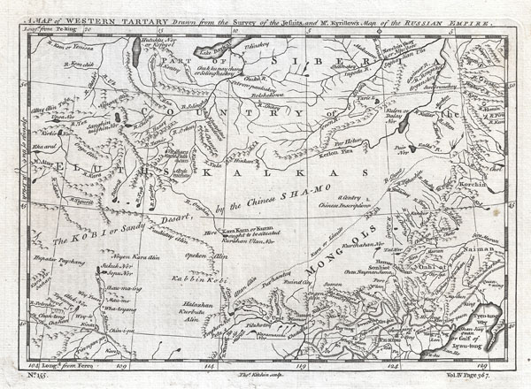
Thomas Kitchin (August 4, 1718 – June 23, 1784) was a London based engraver, cartographer, and publisher. He was born in London to a hat-dyer of the same name. At 14, Kitchin apprenticed under Emanuel Bowen, under whom he mastered the art of engraving. He married Bowen daughter, Sarah Bowen, and later inherited much of his preceptor's prosperous business. Their son, Thomas Bowen Kitchin, also an engraver joined the family business, which thereafter published in Thomas Kitchin and Son. From 1858 or so Kitchin was the engraver to the Duke of York, and from about 1773 acquired the title, 'Royal Hydrographer to King George III.' He is responsible for numerous maps published in the The Star, Gentleman's Magazine, and London Magazine, as well as partnering with, at various times, with Thomas Jefferys, Emmanuel Bowen, Thomas Hinton, Issac Tayor, Andrew Dury, John Rocque, Louis de la Rochette, and Alexander Hogg, among others. Kitchin passed his business on to his son, Thomas Bowen Kitchin, who continued to republish many of his maps well after his death. Kitchin's apprentices included George Rollos, Bryant Lodge, Thomas Bowen Kitchin, Samuel Turner Sparrow, John Page, and Francis Vivares. More by this mapmaker...

Source


Astley, Thomas, A New General Collections of Voyages and Travels, London, 1747.    

Condition


Very good. Clean dark impression. Blank on verso. Original platemark visible.