This item has been sold, but you can get on the Waitlist to be notified if another example becomes available, or purchase a digital scan.

1761 Homann Heirs Map of Westphalia ( Bremen, Hamburg, Cologne, Bonn, etc. )

Westphaliae-hmhr-1761
$137.50
Circuli Westphaliae Quoad partem septentrionalem in sous Status ecclesiasticos & seculares divisi Tabula Geographica edita sumtibus Homannianorum Heredum Norimbergae Ao. 1761. - Main View
Processing...

1761 Homann Heirs Map of Westphalia ( Bremen, Hamburg, Cologne, Bonn, etc. )

Westphaliae-hmhr-1761


Title


Circuli Westphaliae Quoad partem septentrionalem in sous Status ecclesiasticos & seculares divisi Tabula Geographica edita sumtibus Homannianorum Heredum Norimbergae Ao. 1761.
  1761 (dated)     22.5 x 19.25 in (57.15 x 48.895 cm)

Description


A beautifully detailed c. 1761 Homann Heirs map of Westphalia. Covers from Bremen and Hamburg in the north to Cologne, Bonn, Dusseldorf, Aix, Wyck and Luttich in the south. Arnheim, Nimmegen, Wesel, Munster, Minden, Cassel, Hannover, and Meppen also shown. The map details fortified cities, villages, roads, bridges, forests, castles and topography. The title cartouche in the upper left quadrant features a cherubic child frolicking. This map was drawn in Nuremberg and included in the c. 1760 edition of Homann Heirs Maior Atlas Scholasticus ex Triginta Sex Generalibus et Specialibus…. .

Cartographer


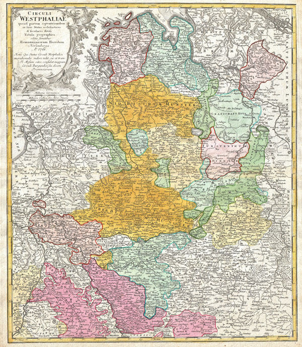
Homann Heirs (1730 - 1848) were a map publishing house based in Nurenburg, Germany, in the middle to late 18th century. After the great mapmaker Johann Baptist Homann's (1664 - 1724) death in 1724, management of the firm passed to his son Johann Christoph Homann (1703 - 1730). J. C. Homann, perhaps realizing that he would not long survive his father, stipulated in his will that the company would be inherited by his two head managers, Johann Georg Ebersberger (1695 - 1760) and Johann Michael Franz (1700 - 1761), and that it would publish only under the name 'Homann Heirs'. This designation, in various forms (Homannsche Heirs, Heritiers de Homann, Lat Homannianos Herod, Homannschen Erben, etc..) appears on maps from about 1731 onwards. The firm continued to publish maps in ever diminishing quantities until the death of its last owner, Christoph Franz Fembo (1781 - 1848). More by this mapmaker...

Source


Major Atlas Scholasticus Ex Triginta sex Generalibus et Specialibus Mappis Homannianis..., c. 1760.    

Condition


Very good condition. Original centerfold. Original platemark visible. Blank on verso.

References


Stanford University, Map Collection, Germany 0292 a, b. Phillips (Atlases), 4195.13.