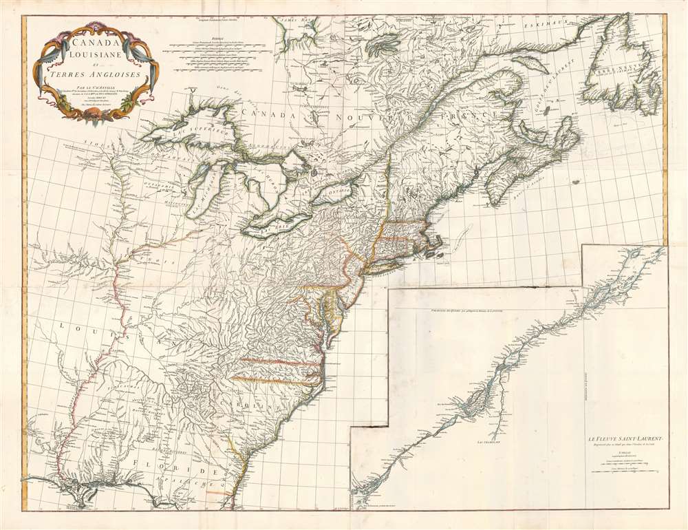
Title
Canada Louisiane et Terres Angloises.
1755 (dated)
34 x 45 in (86.36 x 114.3 cm)
1 : 2900000
Description
This is Jean-Baptiste Bourguignon d'Anville's 1755 map of North America from the Mississippi watershed eastwards. It spans from Newfoundland and James' Bay to St. Augustine, Florida. The map reaches westward as far as modern day Texas, and extends eastward to embrace Newfoundland. It details the English colonies along the Atlantic seaboard, as well as French claims in Louisiana (the Mississippi Valley) and modern day Canada. Elevation is rendered in profile with fortifications, towns, and American Indian villages identified. A large inset centered on Montreal details the course of the St. Lawrence River from the Isle Aux Coudres to Lake Ontario.
A Timely Response to the Mitchell Map
The map is a response to the English Mitchell map, which was published the same year, and upon which to a certain extent the D'Anville is based. This French rebuttal removes references to English factories and settlements in some contested areas; at the same time, it adds detail from French sources which would not have been available to Mitchell. This results in D'Anville's superior representation of the Great Lakes, as noted by Tooley. Asserting French Claims
D'Anville's map is significant on many levels, not the least of which is its presentation, from a French perspective, of the territorial alignments and claims of North America shortly following the outbreak of the French and Indian War (1754 - 1763). Most consider the French and Indian War to be a microcosm of the global Seven Years War. Hostilities in America, nonetheless, began prior to the broader engagement in Europe. The American theatre was distinct in being largely fought by proxy, by parties only loosely aligned with the French or English - most specifically American Indians and lawless frontiersman, who had their own political agendas. The French and Indian War
The war began with French incursions into western Pennsylvania and other territories claimed simultaneously by French, English, and American Indian forces. Just prior to the war, the French, in the interest of broadening their hold on the lucrative fur trade, established a series of forts, all of which are here noted, along the length of the Mississippi and further east, including Fort Duquesne (here Fort de Quene, Pittsburgh), Fort de la Presquisle, and for Le Beouf (here, Fort de la Riv Jaus Beufs). D'Anville accordingly recognizes British claims only inland as far as the Appalachian Mountains, beyond which place names take on a noticeably French character. These last three forts occupied particularly contested territory under the control of the powerful British-allied Iroquois League. The most contested was Fort Duquesne, which stood at the Forks of the Ohio (modern day Pittsburgh) in direct opposition to another fort then being constructed by the Ohio Company, a trading and land speculation firm established by prominent Virginia colonials, including George Washington. The Virginia colonial governor responded to Duquesne by sending then Lieutenant George Washington and a band of Virginia militiamen to harass the French. The resulting Jumonville Affair, in which Washington oversaw an attack on a French-Canadian diplomatic force led by Joseph Coulon de Villiers de Jumonville to warn the Ohio Company fort builders away from French claimed territory. The slaying of Jumonville and several other French diplomats prompted a response from French forces at Fort Duquesne, leading to Washington's retreat and construction of Fort Necessity, really little more than a palisaded shack, marked here just south of Fort Duquesne. These events, all of which occurred in May of 1754, were said to have increased hostilities in Europe and led to the start of the Seven Year War in 1755. Mapping the Missouri
The Missouri River is mapped as far as just beyond the fork of the Kansas River; the settlement of Kansez is shown at the fork. The mapping of the Missouri appears to be derived from the explorations of Étienne de Veniard, Sieur de Bourgmont. He, in 1723, established Fort Orleans, whose location is marked abandoné (it was either abandoned or massacred in 1726.) Second Only to the Mitchell
Beyond the political agenda of this map it is significant as being one of the finest and most heavily detailed maps of North America to appear in the 1750s, second only to the 1755 Mitchell map in detail despite being, in some ways, cartographically superior. Drawing on both French and British cartographic data, Anville identifies countless American Indian tribes, many of which, like the Sioux and Missouri, the British had only vague knowledge of. Moreover, d'Anville also maps swamps, rapids, fords, abandoned villages, and even the ancient remnants of mound builder culture in the Ohio Valley. Anville notably does not include Mitchell's fictional Lake Superior islands.Publication History and Census
This map was originally published to accompany the pamphlet entitled Memoire sur la carte intitulee: Canada, Louisiane, and Terres angloises. It was also published in four parts for Anville's Atlas General. The map is well represented in institutional collections.
CartographerS
Jean Baptiste Bourguignon d'Anville (1697 - 1782) was perhaps the most important and prolific cartographer of the 18th century. D'Anville's passion for cartography manifested during his school years when he amused himself by composing maps for Latin texts. There is a preserved manuscript dating to 1712, Graecia Vetus, which may be his earliest surviving map - he was only 15 when he drew it. He would retain an interest in the cartography of antiquity throughout his long career and published numerous atlases to focusing on the ancient world. At twenty-two D'Anville, sponsored by the Duke of Orleans, was appointed Geographer to the King of France. As both a cartographer and a geographer, he instituted a reform in the general practice of cartography. Unlike most period cartographers, D'Anville did not rely exclusively on earlier maps to inform his work, rather he based his maps on intense study and research. His maps were thus the most accurate and comprehensive of his period - truly the first modern maps. Thomas Basset and Philip Porter write: "It was because of D'Anville's resolve to depict only those features which could be proven to be true that his maps are often said to represent a scientific reformation in cartography." (The Journal of African History, Vol. 32, No. 3 (1991), pp. 367-413). In 1754, when D'Anville turned 57 and had reached the height of his career, he was elected to the Academie des Inscriptions. Later, at 76, following the death of Philippe Buache, D'Anville was appointed to both of the coveted positions Buache held: Premier Geographe du Roi, and Adjoint-Geographer of the Academie des Sciences. During his long career D'Anville published some 211 maps as well as 78 treatises on geography. D'Anville's vast reference library, consisting of over 9000 volumes, was acquired by the French government in 1779 and became the basis of the Depot Geographique - though D'Anville retained physical possession his death in 1782. Remarkably almost all of D'Anville's maps were produced by his own hand. His published maps, most of which were engraved by Guillaume de la Haye, are known to be near exact reproductions of D'Anville' manuscripts. The borders as well as the decorative cartouche work present on many of his maps were produced by his brother Hubert-Francois Bourguignon Gravelot. The work of D'Anville thus marked a transitional point in the history of cartography and opened the way to the maps of English cartographers Cary, Thomson and Pinkerton in the early 19th century. More by this mapmaker...
Guillaume-Nicolas Delahaye (1725 - February 24, 1802) was the most prolific member of the Delahaye (De-La-Haye) family of engravers active in Paris throughout the 18th century. Given that the name, Delahaye literally translates to 'of the Hague' it can be assume they were French Huguenots who were forced to flee the Netherlands under threat of religious persecution. Born in Paris, he was the son of patriarch Jean-Baptiste Delahaye and brother to Jean-Baptistie-Henri Delahaye. It is said that his godfather, who held him at the baptismal font, was none other than the famous french cartographer Guillaume de L'Isle. The Delahaye family engraved for many of the great cartographers of 18th century Paris, including Jean-Baptiste Bourguignon d'Anville, Didier Robert de Vaugondy, Jean-Baptiste de Mannevillette, and Jean-Nicolas Buache, among others. He was awarded the public office Premier Graveur du Roi and worked on a series of maps illustrating the king's hunts around Versailles. Guillaume also worked with foreign cartographers such as Tomas Lopez of Madrid. Possibly Delahaye's most significant map is A Map of the Country between Albemarle Sound and Lake Erie prepared for the memories of Thomas Jefferson. He married in 1758. In total he engraved some 1200 maps. Delahaye died in Charenton. In 1792, his daughter, Antoinette Marie Delahaye (1773-1857), married the geographer Jean-Denis Barbie du Bocage. Learn More...
Source
Memoire sur la Carte Intitulee: Canada, Louisiane, and Terres angloises, (Paris) 1756.
Condition
Very good condition. Some creasing on original fold lines. Four panels, joined.
References
Rumsey 2603.036. OCLC 20257868. Kershaw, Early printed maps of Canada v. 2, 353. Karrow, 1-0602. Lowery, W., The Lowery Collection, 408. Journal des scavans, juin 1756, p. 23-34; cf. P-Maps, p. 575 (1780 ed.); Library of Congress, Maps and charts of North America and the West Indies, 17 (1780 ed.). National Maritime Museum, 200, no. 91-94. New York Public Library, Map Division, 01-5335. Cumming, W., The Southeast in Early Maps, 296. Karpinski, L. C., Bibliography of the Printed Maps of Michigan, 1804-1880, LIX. Tooley, R. V. 'Mapping of the Great Lakes' pp. 316-317 in The Mapping of America.