This copy is copyright protected.
Copyright © 2024 Geographicus Rare Antique Maps
1863 Proof State of Bachelder's Iconic View of the Battle of Gettysburg
Gettysburg-bachelder-1863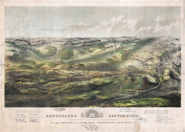

It appears that Mr. Bachelder, having the advantage of a military education, and love of history, went to the front early in 1862, more than a year before the battle of Gettysburg, to be in a position to collect data when the most important battle of the War was fought. After working up the details of several engagements, he reached the battlefield of Gettysburg before the dead were buried, remaining for eighty-four days, making plans of the field, visiting the wounded in hospital, and by permission taking the convalescent officers over the field, by whom their positions and movements were pointed out and established. The product is impressive. Bachelder presents the battlefield in tremendous detail as if seen from a high point to the west. He utilizes dramatic shading to illustrate topography and pictorially illustrates drainage, vegetation, roads and streets, railroads, bridges, houses and names of residents, fences, and points of interest on the battlefield. Even the boundaries between fields are noted. The battle is rendered over time using an ingenious system of color coding that allows the reader to break down the events of the battle as it progresses over three days, from July 1st to the 3rd, 1863. Union General Winfield Scott Hancock, who was seriously wounded during Pickett's Charge, was so impressed by the view that he sent it and Bachelder, accompanied by this view and the following note to President Lincoln so that he might have a better understanding of events.Below the view proper there is a small sketch plan of the Soldiers National Cemetery where the sections dedicated to various states are noted. In addition, there are reproduced signatures of various generals and commanders including A. Doubleday, John Newton, W. S. Hancock, D.B. Birney, G. Sykes, John Sedgwick, O. O. Howard, A. S. Williams, and H. W. Slocum. An additional statement attesting to the accuracy of this view is signed by Major General George G. Meade.My Dear Sir, I think the President would like to see the great map of the battle field of Gettysburg and in order that he may have that opportunity I have sent the author, with a copy of the map to you: The Gentleman’s name is J. B. Bachelder of Boston Mass.
John Badger Bachelder (September 29, 1825 – December 22, 1894), also spelled Batchelder, was an American portraitist, landscape artist, lithographer, cartographer, and photographer. In his life he was best known as the preeminent expert on the 1863 Battle of Gettysburg, of which he produced the most iconic representation. Bachelder was born in Gilmantown, New Hampshire and was educated at Captain Alden Partridge's Military School in Pembroke. Upon graduating he relocated to Reading, Pennsylvania, where he took a position at the Pennsylvania Military Institute. He became the head of that institution in 1851. In 1852 he was appointed colonel of the Pennsylvania State Militia. Around 1853 Bachelder returned to New Hampshire to pursue a career as an artist, publishing various views of New England towns; 1854 found him living and working in Manchester, and perhaps this is what led him to produce four views of the city - more than any other place he depicted in print. Bachelder's military training influenced his art materially and he developed a lifelong interest in depicting the dynamics of great battles on canvas. When the American Civil War broke out in 1861, Bachelder was working on a view of the Revolutionary War battle of Bunker Hill. From his work on the Bunker Hill view, Bachelder noted how difficult it was to reconstruct a battle long after the events when most major participants had passed on. He saw an opportunity in the outbreak of the Civil War and attached himself to the Union Army of the Potomac in the hopes of being present at a major battle. He was welcomed on the battlefield, where his accurate drawings helped the generals to better understand the conflicts in question. His most significant work his an impressive bird's-eye view of the Battle of Gettysburg. Though not present at the battle, he was there day's after, and claims to have interviewed the commanders of every regiment and battery in the Army of the Potomac, as well as thousands of wounded soldiers on both sides of the conflict. His work was so precise and significant he was commended to President Lincoln and later took a position as Superintendent of Tablets and Legends for the Gettysburg Battlefield Memorial Association. He is responsible for the monuments and battlefield markers, both Union and Confederate, that can still be noted today at Gettysburg. He also organized reunions and battlefield tours. Bachelder died of Pneumonia in Hyde Park, Massachusetts, in 1894. He is interred in his family plot in Nottingham, New Hampshire. More by this mapmaker...
Endicott and Company (fl. c. 1828 - 1891) was a New York based family run lithography firm that flourished throughout the 19th century. The firm was founded by George and William Endicott, brothers who were born in Canton, Massachusetts. George Endicott (June 14, 1802 - 1848) trained as a lithographer under Pendleton Lithography from January of 1826. He later worked as superintendent of Senefelder Company until the summer of 1828. Afterwards, in 1830, he relocated to Baltimore and partnered with Moses Swett. Endicott and Swett relocated to New York City in December of 1831. They remained partners until July of 1834 when the relationship dissolved. George set up shop on his own account at 359 Broadway. William Endicott (1815 - 1851), George's younger brother of 14 years, joined the firm in 1840 and was made a partner in 1845, after which the name of the firm was changed to G. and W. Endicott. George Endicott died shortly afterward, in 1848, but William continued operating the firm as William Endicott and Co. until his own 1851 death at just 35 years. The firm was carried on by his widow Sara Munroe Endicott until it was taken over by her son, Francis Endicott, who ran the firm from 1852 to 1886. George Endicott, Jr. subsequently ran the firm from 1887 to 1891. Peters, in his important work on American lithography America on Stone writes "it is hard to summarize the Endicotts. They did everything and did it well . . . [they] worked with and for Currier and Ives, yet in spite of all that much of their work lacks real individuality." The Endicott firm was responsible for many 19th century views and plans of New York City and state as well as plans of Sacramento, California, and the Midwest. Learn More...
Copyright © 2024 Geographicus Rare Antique Maps | Geographicus Rare Antique Maps
This copy is copyright protected.
Copyright © 2024 Geographicus Rare Antique Maps