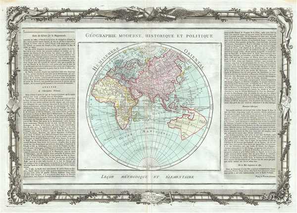
This is an impressive map of the Eastern Hemisphere by Desnos and Brion de la Tour dating to 1786. Depicts the Eastern Hemisphere in beautiful detail covering Asia, Europe, Africa and Australia. Though rife with speculation, the map attempts to present a grand overview of the known world based upon the best reconnaissance available at the time. The routes of many explorers and important recent discoveries are noted.
The northeast parts of Asia, which had recently been explored by Vitus Bering and Tschirikow, are depicted with a fair approximation of accuracy. Terre de Gama and Terre de la Company, speculative mis-mappings of the Japanese Kuril Islands by the 17th century Dutch explorers Maerten de Vries and Cornelis Jansz Coen, appear just northeast of Yedso (Hokkaido). Gama or Compagnie remained on maps for about 50 years following Bering's voyages until the explorations of Cook confirmed the Bering findings.
South of the equator the shores of Australia or New Holland are speculatively mapped with a dotted line defining the southern and eastern portions continent. Van Diemen's Land or Tasmania is attached to the mainland, which itself includes New Guinea and parts of the New Hebrides, identified here as Terre de S. Espirit. Terre du St. Espirit, in fact the New Hebrides was mis-mapped by the near insane 17th century Portuguese navigator Pedro Fernandes de Queiros who proclaimed that he had discovered the Great Southern Continent, or Terre Australis. Not to be confused with modern day Australia, Terre Australis was a vast speculative continent that supposedly covered much of the southern hemisphere in Aristotelian symmetry with the bulk of Asia in the Northern Hemisphere. Although by this time most cartographers had stopped mapping Terre Australis, some, perhaps with the great myth in mind, wishfully increased Australia's dimensions.
To the left and right of the map are paste downs of French text with remarks and description of the map. Surrounding the whole is an elaborate decorative border featuring floral arrangements, surveying tools, elaborate baroque scalloping, and a winged globe. This map was issued as plate no. 9 in the most deluxe edition of Desnos’ 1786 Atlas General Methodique et Elementaire, Pour l’Etude de la Geographie et de l’Histoire Moderne.
CartographerS
Louis Charles Desnos (1725 - April 18, 1805) was an important 18th century instrument maker, cartographer and globe maker based in Paris, France. Desnos was born in Pont-Sainte-Maxence, Oise, France, the son of a cloth merchant. From April of 1745 he apprenticed at a metal foundry. Desnos married the widow of Nicolas Hardy, sone of the map, globe, and instrument seller Jacques Hardy. Desnos held the coveted position of Royal Globemaker to the King of Denmark, Christian VII, for which he received a stipend of 500 Livres annually. In return Desnos sent the King roughly 200 Livres worth of maps, books and atlases each year. As a publisher, Desnos produced a substantial corpus of work and is often associated with Zannoni and Louis Brion de la Tour (1756-1823). Despite or perhaps because of the sheer quantity of maps Desnos published he acquired a poor reputation among serious cartographic experts, who considered him undiscerning and unscrupulous regarding what he would and would not publish. Desnos consequently had a long history of legal battles with other Parisian cartographers and publishers of the period. It is said that he published everything set before him without regard to accuracy, veracity, or copyright law. Desnos maintained offices on Rue St. Jacques, Paris. More by this mapmaker...
Louis Brion de la Tour (1743 - 1803) was the Cartographer Royal to the King of France, his official title being Ingenieur-Geographe du Roi. Despite a prolific cartographic career and several important atlases to his name, little is actually known of his life and career. He may have been born in Bordeaux. His son of the same name was born in 1763 and published until his death in 1832. It is nearly impossible to distinguish the work of the father from the work of the son, as both used the same imprint and were active in roughly the same period. Much of their work was published in partnership Louis Charles Desnos (fl. 1750 - 1790). Their most notable work is generally regarded to be his 1766 Atlas General. Learn More...
Source
Desnos, Louis-Charles, Atlas General Methodique et Elementaire, Pour l’Etude de la Geographie et de l’Histoire Moderne, 1786.
The Atlas general, civil, ecclesiastique et militaire, methodique et elementaire was issued by Louis Brion de la Tour (1756-1823) and Louis Charles Desnos (1725-1805) from about 1764 with subsequent reissued until about 1790. It was intended for use by the 'young nobles of the Ecole Royale Militaire,' but also proved popular with general audiences. The atlas was compiled using an uncommon printing method involving multiple pressings as well as paste downs for each page. Typically maps from the atlas feature an elaborate rococo decorative border containing a smaller map of approximately 10 x 14 inches, a title at the top and bottom of each page, and descriptive text, generally either a pastedown or separate printing to either side of the map. This unusual combination of printings and pastedowns allowed the publisher maximum flexibility and thus it is not uncommon to find variants of this atlas both with and without the decorative borer, with and without the descriptive pastedowns, pastedowns in different languages, and with changing titles for individual maps. There are various different collations for this atlas depending upon where it was intended to be sold. For example, versions sold in the United States and England replace the large map of France with new maps of the United States. It was not uncommonly bound with de la Tour's Atlas National de France.
Very good. Minor toning along original centerfold. Minor spotting at places. Original platemark visible. Water stains on top margin, not affecting printed area.