This item has been sold, but you can get on the Waitlist to be notified if another example becomes available, or purchase a digital scan.

1776 Universal Magazine Map of New York City

NewYorkCIty-universalmagazine-1776
$1,000.00
A Plan of the City and Environs of New York in North America. - Main View
Processing...

1776 Universal Magazine Map of New York City

NewYorkCIty-universalmagazine-1776

The second earliest obtainable map of New York City. Issued just after the outbreak of the American Revolutionary War.

Title


A Plan of the City and Environs of New York in North America.
  1776 (undated)     11.5 x 14.5 in (29.21 x 36.83 cm)     1 : 12000

Description


A rare and important map of New York City issued in John Hinton's Universal Magazine in 1776 shortly following the outbreak of the American Revolutionary War. Considered the second earliest obtainable plan of New York (following Bellin's 1764 Ville De Manathe ou Nouvelle-Yorc) this magazine issue plan illustrated the lower part of Manhattan from modern day 14th street (or so) to the Battery. It also includes significant parts of Brooklyn just across the East rover including Brooklyn Heights, the Wallabout Bay (Brooklyn Navy Yard), and Williamsburg.

Cartographically the mapmaker based this map on the work of Bernard Ratzen (1767) and John Montresor (1766), with certain revisions and updates. One such is the addition of the name 'Delaney's New Square' to a public square at the center of a new street grid developed on the Delancey estate in today's Lower East Side. This square actually appears in the Ratzen map, but he refers to it as the 'Great Square'. Several important streets are noted including Broadway. The map notes the 'Road to Kings Bridge' (modern day Broadway) where, it notes, 'the Rebels mean to make a stand' and the 'Road to Kepps Bay where the King's Troops Landed.' Across the East River, the landing of the Brookland Ferry in modern day Brooklyn Heights is noted.

This map was issued in direct response to renewed British interest in the colonies following the April 1776 outbreak of the American Revolutionary War. Following the early success of the New York Campaign, which forced George Washington and the Continental Army to flee New York City, the British must have imagined the war nearly over. Hinton no doubt hoped to capacities on popular interest in the war associated with these British victories.

This map was issued in the November 1776 issue of the Universal Magazine of Knowledge and Pleasure. The identity of the cartographer is unclear by it may have been Thomas Kitchin or Richard Seale. While popular in its initial issue, this map has become increasingly scarce on the market with only 2 or 3 examples appearing in the last 10 years.

Cartographer


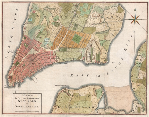
John Hinton (November 13, 1716 - May 11, 1781) was a British bookseller and publisher active in London during the late 18th century. Hinton is best known as the publisher of the Universal Magazine of Knowledge and Pleasure, a popular English periodical issued from 1747 to 1814. The Universal Magazine enjoyed wide appeal and was often lavishly illustrated - for the time - with engravings and maps by such prominent English cartographers as Emanuel Bowen, Thomas Kitchin, and Richard W. Seale. On Hinton's death publication of the Universal Magazine was taken over by his apprentice Stephen Austin Cumberlege. More by this mapmaker...

Source


Universal Magazine of Knowledge and Pleasure (London: John Hinton) Nov. 1776, v. 59.    

Condition


Good. Some restoration to several closed tears extending fom the right side of the map Backed on archival paper.

References


Jolly, D. C., Maps in British Periodicals, UNIV-177. Sellers, John R. and Van Ee, Patricia, Maps and Charts of North America, no. 1110. Nebenzahl, K., A Bibliography of Printed Battle Plans of the American Revolution 1775-1795, #114.