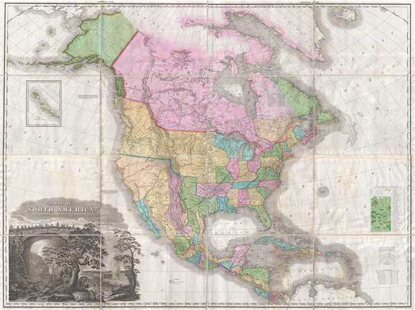
An attractive example of Henry Schenk Tanner's remarkable 1825 landmark map of North America, considered to be the most important map of North America of the 19th century. Revolutionary in countless ways, this is the most accurate map of North America, in particular the unexplored western parts, the world of 1825 had yet seen. The task before Tanner in assembling this map, piecing together the cartography of an unknown country from piecemeal, often unreliable reports, was monumental to say the least. Tanner draws on Aaron Arrowsmith, Lewis and Clark, Alexander von Humboldt, Zebulon Pike, Stephen Harriman Long, Daniel Williams Harmon, George Vancouver, and others.
The map is broad in scope, cover from the high arctic and the Bearing Strait to the northern part of South America. It includes all of North America, from Alaska to Panama, including Greenland, Iceland, the West Indies, Central America, and the Aleutian Islands. The United States is presented according the pre-Mexican American War boundaries. British Columbia, called New Hanover is tied to the massive Oregon territory as far north as 54° 40' Latitude – a claim that would later become an issue of international contention. The United States boundary with Mexico follows the 1819 Adams-Onís Treaty and runs along the Sabine River to the Red River, to the 100th Meridian West, to the Arkansas River, then west to that river's source at the 42nd parallel which it follows to the Pacific.
Much of the American west is unexplored. For coastal outlines Tanner uses Vancouver. Inland he relies on Zebulon Pike and Stephen Harriman Long, often times recognizing and correcting, at great effort, discrepancies and inconsistencies in their reports. Longs Peak is identified and for the first time named as such. For much of the lands beyond the Rocky Mountains, Tanner relies on Humboldt's map of 1811. Although not based upon actual exploration, Humboldt was masterful at sorting the wheat from the chaff when studying old missionary and conquistador reports and thus produced an impressively useful map. The Sierra Nevada Mountains are not present. The Sierra Madre are in evidence but truncated at the northern ends. Tanner adds an annotation,
These Mountains are supposed to extend much farther to the north than here shewn: but there are no data by which to trace them with accuracy.
Instead Tanner follows earlier conventions and unreliable monastic reports by adding three fictional rivers, the Rio San Buenaventura, flowing from Lake Utah, labeled here
Salt Lake; the Rio Timpanagos, flowing from Great Salt Lake, labeled here
Lake Timpanagos; and the Los Mongos River, also flowing from
Lake Timpanagos. Tanner funnels the Timpanagos River into San Francisco Bay, labeled here
Port Sir Frans. Drake, which is, for all intent and purpose, unrecognizable as Vancouver, his primary source for the west coast, never explored the Bay Area.
The cartographer identifies a hypothetical 'Great Bear Lake' just east of Prince of Wales Island. This is not to be confused with the factual 'Great Bear Lake' correctly located to the north of 'Great Slave Lake.' Apparently this, along with much of the other information about the Pacific Northwest was derived from the 1820 journal of Bennington, Vermont, native, fur trader, and explorer with the Northwest Company Daniel Williams Harmon (February 19, 1778 – April 23, 1843). Harmon himself never saw the supposed lake, but rather noted it in his journal based upon representations by Native Americans he encountered trading fur.
In the lower let quadrant there is a dramatic title cartouche featuring some of the flora, fauna, and natural wonder of America. Niagara Falls and the impressive Virginia Natural Land Bridge are prominent. The picture of Niagara is a combination of Vanderlyn's 'A View of the Westerly Branch,' used for the Horseshoe Falls portion of the image, and the left part of his 'A Distant View of the Falls of Niagara,' used for the American Falls portion of the image. In the foreground some of the more important New World fauna, the beaver, a stag, and a bear, are presented. The cartouche does much to capture both the wildness and rich natural resources of the North American continent.
This map was first issued in 1822 and the copyright here reflects that date. There were 4 subsequent states, each with only minor updates and revisions. This is the fourth.
- State 1. First edition Does not include Franklin's Gulf in the Arctic or the 1824 Russian Boundary.
- State 2. Franklin's Gulf added.
- State 3. 1824 Russian boundary and 'Improved to 1825' added to title.
- State 4. 1825 boundary in the far northwest.
- State 5. Title changed to 'Improved to 1828.'
It was issued in the 1825 printing of Tanner's
New American Atlas. Tanner's map went on to have a lasting influence on American history and cartography, even long after it was outdated. The Disturnell map of Mexico,
Mapa de los Estados Unidos De Mejico, used to the Treaty of Guadeloupe Hidalgo, for example, is based heavily on this map. The map was also used in the Alaskan Boundary Tribunal of 1903.
Cartographer
Henry Schenck Tanner (1786 - May 18, 1858) was one of the preeminent American map engravers and publishers of the early 19th century - what is considered to be the "Golden Age of American Map Publishing". Born in New York City but based in Philadelphia, Tanner's forty plus year career was almost entirely focused on cartographic work. His earliest map work appears in conjunction with another important map publisher, John Melish. Early in his career, Tanner partnered with his brother Benjamin, to engrave extensively for Melish as well as other Philadelphia publishers including Lucas Fielding (Baltimore), A. Bourne, Jason Torey, Samuel Harrison, and Samuel Lewis, among others. In 1818 Tanner convinced his fellow publishers and partners to finance the compilation of a New American Atlas. The atlas was sold by subscription and slowly emerged between 1819 and 1823. The New American Atlas, possibly the pinnacle of 19th century American cartography and was commended in its day as "one of the most splendid works of the kind ever executed in this country". It was subsequently republished in several updated editions until about 1839. Tanner had by this time become the most active and influential map publisher in the United States. Around 1832, recognizing the market for a less cost prohibitive atlas, Tanner began work on the smaller format New Universal Atlas. This popular and important atlas went through numerous editions before being bought out by Carey and Hart, and then, in 1846, by S. A. Mitchell, who would rise to become the preeminent publisher of the next generation. In addition to these important atlases, Tanner also issued numerous extremely important and influential travelers guides, state maps, wall maps, and pocket maps. He should not be confused with his brother, also an America map engraver, the New Yorker Benjamin Tanner. More by this mapmaker...
Source
Tanner, H. S.,
A New American Atlas, (Philadelphia: Tanner) 1825.
Tanner's
New American Atlas is regarding as the largest and most beautiful early American atlas, truly a landmark achievement from the Golden Age of American Cartography. The atlas was initially published in five parts between 1819 and 1823, after which collected editions were issued in 1823, 1825, 1833, and 1839. It terms of size, format, printing quality, paper quality, cartographic accuracy, and elegance of engraving, the
New American Atlas was unparalleled. As noted by map historian Walter Ristow, 'Tanner's atlas raised U.S. commercial map production to a new level of excellence.' His contemporaries were also duly impressed. The American educator and historian Jared Sparks, as quoted by Ristow, describes the atlas as thus:
on the whole as an American Atlas, we believe Mr. Tanner’s work to hold a rank far above any other, which has been published. The authentic documents, to which he had access, the abundance of his materials, the apparent fidelity, with which they are compiled, the accurate construction of his maps, and the elegance with which they are executed, all these afford ample proofs of the high character of the work, of its usefulness as a means of extending the geographic knowledge of our own country, and of its claims to public patronage. (Ristow, p. 197)
Very good, near flawless example.
Rumsey 2755.007. OCLC 11440047. Wheat, C. I., Mapping of the Transmississippi West, 1540 – 1861, #350, Vol 2, pages 82 - 87. Ristow, W., American Maps and Mapmakers: Commercial Cartography in the Nineteenth Century, pages 191-198.