Title
Spain and Portugal.
1835 (undated)
17 x 21 in (43.18 x 53.34 cm)
1 : 2304000
Description
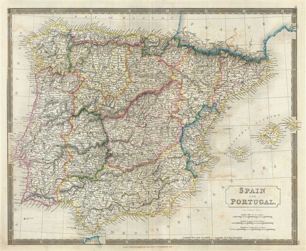
This is a beautiful map of Spain and Portugal from Sidney Hall's extremely scarce 1835 New General Atlas. It covers the entirety of Iberia including the Balearic Islands of Minorca, Majorca, and Ibiza. Both countries are covered in full, with Spain being divided into its various semi-autonomous provinces. The Strait of Gibraltar is also noted along with the Tangier in Africa. Several battlegrounds are identified, including the 1808 Battle of Vimeriro, the 1797 Battle of Cape St. Vincent (here noted as Sir J. Jervis), and of course the 1805 Battle of Trafalgar, among others. Towns, rivers, mountains, railroads, canals, marshes, forests, and various other important topographical details are noted. Elevation throughout is rendered by hachure and political and territorial boundaries are outlined in color.
As this map was issued, Spain was in the midst of the First Carlist War. The death of Ferdinand VII saw his daughter, Isabella II, an infant at the time, proclaimed Queen with his wife, Maria Cristina, regent. Infante Carlos, Ferdinand's brother disputed Isabella's claim to the throne. This would eventually result in a civil war from 1833-1839. Meanwhile, in Portugal this map shortly follows on the War of the Two Brothers. In 1826, Peter IV of Portugal abdicated his throne in favor of his seven year old daughter Maria da Gloria, on the condition that she marry her uncle (Peter's brother) Miguel. Miguel deposed Maria and proclaimed himself king, leading to the Liberal Wars, and eventually in Miguel being forced to abdicate and go into exile. Maria da Gloria was proclaimed queen in 1834 and resumed her reign as Maria II of Portugal.
Sidney Hall's New General Atlas was published from 1830 to 1857, the first edition being the most common, with all subsequent editions appearing only rarely. Most of the maps included in the first edition of this atlas were drawn between 1827 and 1828 and are most likely steel plate engravings, making it among the first cartographic work to employ this technique. Each of the maps in this large and impressive atlas feature elegant engraving and an elaborate keyboard style border. Though this is hardly the first map to employ this type of border, it is possibly the earliest to use it on such a large scale. Both the choice to use steel plate engraving and the addition of the attractive keyboard boarder are evolutions of anti-forgery efforts. Copper plates, which were commonly used for printing bank notes in the early 19th century, proved largely unsuitable due to their overall fragility and the ease with which they could be duplicated. In 1819 the Bank of England introduced a £20,000 prize for anyone who could devise a means to print unforgeable notes. The American inventors Jacob Perkins and Asa Spencer responded to the call. Perkins discovered a process for economically softening and engraving steel plates while Spencer invented an engraving lathe capable of producing complex patters repetitively - such as this keyboard border. Though Perkins and Spenser did not win the prize, their steel plate engraving technique was quickly adopted by map publishers in England, who immediately recognized its value. Among early steel plate cartographic productions, this atlas, published in 1830 by Longman Rees, Orme, Brown & Green stands out as perhaps the finest. This map was issued by Sidney Hall and published by Longman Rees, Orme, Brown & Green of Paternoster Row, London, in the 1835 edition of the Sidney Hall New General Atlas.
Cartographer
Sidney Hall (1788 - 1831) was an English engraver and map publisher active in London during the late 18th and early 19th centuries. His earliest imprints, dating to about 1814, suggest a partnership with Michael Thomson, another prominent English map engraver. Hall engraved for most of the prominent London map publishers of his day, including Aaron Arrowsmith, William Faden, William Harwood, and John Thomson, among others. Hall is credited as being one of the earliest adopters of steel plate engraving, a technique that allowed for finer detail and larger print runs due to the exceptional hardness of the medium. Upon his early death - he was only in his 40s - Hall's business was inherited by his wife, Selina Hall, who continued to publish under the imprint, "S. Hall", presumably for continuity. The business eventually passed to Sidney and Selina's nephew Edward Weller, who became extremely prominent in his own right. More by this mapmaker...
Source
Hall, S., A New General Atlas, with the Divisions and Boundaries, 1835.
Condition
Very good. Original platemark visible. Minor wear along original centerfold. Some offsetting. Blank on verso.
References
Rumsey 4224.022 (1830 edition). Philips (Atlases) 758. Ristow, W., American Maps and Mapmakers: Commercial Cartography in the Nineteenth Century, p. 303-09.