This copy is copyright protected.
Copyright © 2024 Geographicus Rare Antique Maps
1887 Burleigh Bird's-Eye View of White Plains, New York
WhitePlains-burleigh-1887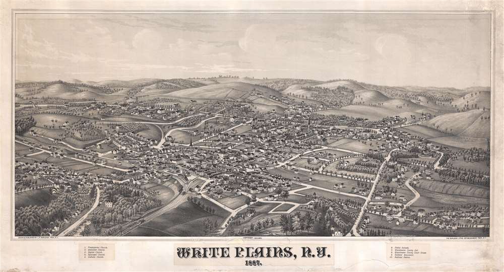

Some print connoisseurs believe that it was only with the advent of the full-blown city-view lithograph that American printmaking reached its first plateau of originality, making a historical contribution to the graphic arts. They cite the differences between the European city-view prints and the expansive American version that reflects a new land and a new attitude toward the land.The vogue for bird's-eye city views lasted from about 1845 to 1920, during which period some 2,400 cities were thus portrayed, some multiple times. Although views were produced in many urban centers, the nexus of view production in the United States was Milwaukee, Wisconsin. The major American viewmakers were Stoner, Wellge, Bailey, Fowler, Hill, Ruger, Koch, Burleigh, Norris, and Morse, among others.
Lucian Rinaldo Burleigh (February 6, 1853 – July 30, 1923) was an American lithographer and view maker active in the latter part of the 19th century. Burleigh was born in Plainfield, Connecticut and studied civil engineering at Worcester County Free Institute of Industrial Science (Worcester Polytechnic). There he studied under George E. Gladwin who specialized in field sketching. Burleigh became one of Gladwin's prized students and this no doubt influenced his choice to become a viewmaker. Burleigh's view work stands out for two reasons. One, most of his town views are drawn form a lower than usual point of view enabling him to take greater advantage of profile perspectives. Two, his views do not integrate people or animals – most late 19th century American view artists added horses, people, carts, dogs, and even chickens to their views. Between the years of 1883 and 1885 Burleigh produced some 28 views of New York towns and cities. Most of these were published by either Beck and Pauli of Milwaukee or C. H. Voght of Cleveland. After 1886, Burleigh established his own Troy press and subsequent views were published in-house. Burleigh also worked as a lithographer for other view makers including J. J. Stoner and Albert Ruger, among many others. Burleigh contributed to the production of about 228 lithographic city views and personally drew about 120, marking him one of the most important and influential viewmakers of the 19th century. More by this mapmaker...
Copyright © 2024 Geographicus Rare Antique Maps | Geographicus Rare Antique Maps
This copy is copyright protected.
Copyright © 2024 Geographicus Rare Antique Maps