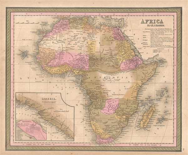
This is a Samuel Augustus Mitchell 1850 map of Africa and Liberia. The map depicts the continent of Africa from the Mediterranean Sea to the Cape of Good Hope and from the Atlantic Ocean and the Cape Verde Islands to Arabia and the Indian Ocean. At this point in history, Africa was on the cusp of the great European exploratory expeditions of the mid-19th century undertaken by Speke, Livingstone, and Stanley. Much of the interior remains unknown, even speculative. Political and topographical features are noted and color coded with elevation rendered by hachure.
The 'Supposed Mountains of the Moon' stretch across the continent – a relic 5th century B.C. speculations regarding the source of the Nile. The course of the Niger is speculatively mapped along what is roughly its correct course. Lake Malawi, near Mozambique, appears in embryonic form, no doubt drawn from indigenous and missionary reports, but gives some hint of the Great Rift Valley lakes soon to be discovered. European colonies and outposts dot the coastlines and the great Arab caravan routes across the Sahara are noted. In the lower left corner there is a detail of Liberia drawn from Gurley's report. Liberia, which had been founded in 1821 as a refuge for free blacks from the United State had, just a few years previous in 1847, become an independent state and was an object of curiosity for Mitchell's largely American audience.
The whole is engraved and colored in Mitchell's distinctive style with green border work and vivid pastels. Mitchell published this chart in his atlas from 1846 to the late 1850s before discontinuing the series and selling his map plates to DeSilver. This map was issued in the 1850 edition of the New Universal Atlas.
Cartographer
Samuel Augustus Mitchell (March 20, 1792 - December 20, 1868) began his map publishing career in the early 1830s. Mitchell was born in Bristol, Connecticut. He relocated to Philadelphia in 1821. Having worked as a school teacher and a geographical writer, Mitchell was frustrated with the low quality and inaccuracy of school texts of the period. His first maps were an attempt to rectify this problem. In the next 20 years Mitchell would become the most prominent American map publisher of the mid-19th century. Mitchell worked with prominent engravers J. H. Young, H. S. Tanner, and H. N. Burroughs before attaining the full copyright on his maps in 1847. In 1849 Mitchell either partnered with or sold his plates to Thomas, Cowperthwait and Company who continued to publish the Mitchell's Universal Atlas. By about 1856 most of the Mitchell plates and copyrights were acquired by Charles Desilver who continued to publish the maps, many with modified borders and color schemes, until Mitchell's son, Samuel Augustus Mitchell Junior, entered the picture. In 1859, S.A. Mitchell Jr. purchased most of the plates back from Desilver and introduced his own floral motif border. From 1860 on, he published his own editions of the New General Atlas. The younger Mitchell became as prominent as his father, publishing maps and atlases until 1887, when most of the copyrights were again sold and the Mitchell firm closed its doors for the final time. More by this mapmaker...
Source
Mitchell, S. A., A New Universal Atlas, (S. A. Mitchell; Philadelphia) 1850.
The New Universal Atlas is one of the great American atlases of the mid-19th century. Samuel Augustus Mitchell first issued the atlas in 1846 when he acquired the map plates and copyright for Tanner's New Universal Atlas from its publisher, Carey and Hart. The first transitional 1846 edition was published jointly with Carey and Hart, but a second edition was published in the same year with the Tanner imprint erased. This edition of the atlas also introduced the signature S. A. Mitchell green and pink color scheme. Most of the maps from the early editions of the atlas were engraved by H. N. Burroughs or C. S. Williams, often bearing their copyright. Burroughs maps also tended to have what map collector David Rumsey refers to as the 'Cary and Hart' borders, which featured a narrow vine motif. These borders were replaced, along with the Burroughs imprint, with the more traditional Mitchell strap work border used in the atlases until 1856. Mitchell published editions until late in 1850, when he sold the rights to Thomas, Cowperthwait and Company of Philadelphia. Under Cowperthwait, the atlases continued to be published and bear the Mitchell name until 1856, when it the plates were again sold, this time to Charles Desilver. Desilver reworked the plates with new border art and a revised color scheme in the style of J. H. Colton. Desilver issued editions from 1857 to 1860, when the atlas was phased out in favor of Samuel Augustus Mitchell Jr.'s New General Atlas.
Very good. Even overall toning. Minor foxing. Blank on verso.
Rumsey 4835.085.