This copy is copyright protected.
Copyright © 2024 Geographicus Rare Antique Maps
1665 Kircher Map of Southern Africa
Africae-kircher-1665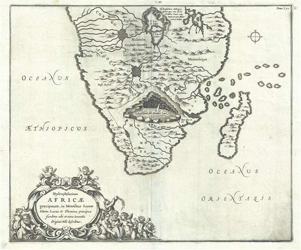

On the 21st April in the year 1618, being there with the King and his army, I ascended the place and observed everything with great attention: I discovered first two round fountain each bout four palms in diameter, and saw with the greatest delight what neither Cyrus, the King of the Persians, or Cambysis, nor Alexander the Great, nor the famous Julius Caesar could ever discover. The two openings of these fountains have no issue in the plain on top of the mountain but flow from the root of it. The second fountain lies about a stone-cast west from the first: the inhabitants say that this whole mountain is full of water and add that the whole plain about the fountain is floating and unsteady, a certain mark that there is water concealed under it.Of course, Paez was referring to the source of the Blue Nile, later discovered by Bruce in Ethiopia, far to the north of this map's coverage. Although Kircher's theories were revolutionary at the time, they seem simplistic, even ridiculous to us today. Nonetheless, Kircher's maps were among the first thematic maps to attempt to scientifically illustrate and explain global geological and oceanographic phenomena.
Athanasius Kircher (c. 1601 - 1680) was a 17th century German Jesuit scholar and one of the most respected and remarkable men of his time. A master of languages, mathematics, science, geography, physics and oriental studies, many consider Kircher to be 'the last true Renaissance man.' Kircher attained almost global fame in his lifetime for his numerous scholarly publications. Indeed, Kircher was the first documented scholar able to fully support himself on his own work, which, in his case, included some forty volumes on diverse fields. As a Catholic in Germany, Kircher was frequently at odds with the rising powers of Protestantism. Consequently, in 1628 he joined the priesthood and after extensive world travels eventually settled in Rome. There he was employed as a Professor of Mathematics and Oriental Languages at the Collegio Romano. Inspired by the eruption of Vesuvius in 1637 and the two weeks of earthquakes that shook Calabria in 1638, Kircher turned his considerable intellect to the natural world. Kircher's research into Geography and Oceanography culminated in the postulation that tides and currents were caused by water moving to and from a great subterranean ocean. Kircher published his geographic work in the important 1664 Mundus Subterranous, which in addition to several world and oceanic charts, included a fascinating map of Atlantis. Kircher is nonetheless, not unimpeachable. One anecdote tells how a rival scholar presented Kircher with a manufactured gibberish manuscript he claimed to be an recently discovered ancient Egyptian text in need of translation. Kircher produced the translation instantly. In addition to his significance as a scholar, Kircher is best known for his invention of the Magic Lantern, precursor to modern cinema. He also founded the Museum Kircherianum in Rome. More by this mapmaker...
Copyright © 2024 Geographicus Rare Antique Maps | Geographicus Rare Antique Maps
This copy is copyright protected.
Copyright © 2024 Geographicus Rare Antique Maps