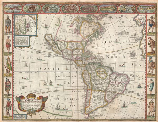
A nice example of John Speed's 1626 map of America here in its fourth or 1676 state. One of the most iconic maps of America ever made, this map is surrounded by decorative vignettes illustrating the indigenous peoples and cities of the Americas. This map is both beautiful and important. It features a number of first, including being the first atlas map to depict California as an island and to accurately depict the east coast of North America. Cartographically it follows on the earlier maps of the Dutchman Abraham Goos, the engraver, with updates to reflect the 1625 Briggs vision of an insular California.
This is the first atlas map to represent California as an island. The idea of an insular California first appeared as a work of fiction in Garci Rodriguez de Montalvo's c. 1510 romance Las Sergas de Esplandian, where he writes
Know, that on the right hand of the Indies there is an island called California very close to the side of the Terrestrial Paradise; and it is peopled by black women, without any man among them, for they live in the manner of Amazons.
Baja California was subsequently discovered in 1533 by Fortun Ximenez, who had been sent to the area by Hernan Cortez. When Cortez himself traveled to Baja, he must have had Montalvo's novel in mind, for he immediately claimed the 'Island of California' for the Spanish King. By the late 16th and early 17th century ample evidence had been amassed, through explorations of the region by Francisco de Ulloa, Hernando de Alarcon and others, that California was in fact a peninsula. However, by this time other factors were in play. Francis Drake had sailed north and claimed 'New Albion' (identified here on the northwest coast of California Island) near modern day Washington or Vancouver for England. The Spanish thus needed to promote Cortez's claim on the 'Island of California' to preempt English claims on the western coast of North America. Henry Briggs, an English mathematician, began promoting the idea of an insular California in 1622, citing the journals of Friar Antonio de la Ascension, who accompanied the 1602-03 Sebastian Vizcaino expedition. The significant influence of the Spanish crown on European cartographers caused a major resurgence of the Insular California theory. Just before this map was made Eusebio Kino, a Jesuit missionary, traveled overland from Mexico to California, proving conclusively the peninsularity of California. Even so, it was ultimately a 1747 royal decree from King Ferdinand VII of Spain that finally forced cartographers to give up on the alluring idea.
Other elements of interest in North America are the complete absence of the Great Lakes - which in 1626 had yet to be conceived of by any European cartographers. The Straits of Anian appear tenuously in the extreme northwest, just above California. Just east of the 'o' in 'California', on the continental mainland, there is a curious ghosted in lake called the 'Lagueo de Oro.' We have found no references or explanation for this. None of the legendary kingdoms of gold, Quivara, Teguayo, Cibola, etc. are noted. The western portions of the Hudson Bay are unmapped - suggestive of their unexplored status. The addition of Long Island and Boston, in notably darker print, are important updates over the earliest editions.
South America offers much of interest including the mythical Lake Parimia, in Guiana. The legend of Parima is associated with the English adventurer Sir Walter Raleigh's search for El Dorado. Believing El Dorado to lie in the northern part of the Amazon, Raleigh sailed down the Orinoco River just before the onset of the rainy season. Reaching a remote tribal village, Raleigh noted canoes arriving bearing gold, silver, and other treasures. Asked where the gold came from, the natives replied, 'Manoa', the term for the tribe to which the river traders belonged. Manoa, the natives claimed could be reached following a long river voyage southward to a Great Lake, called Parima. Raleigh and his associates immediately associated Manoa and Lake Parima with the golden kingdom of El Dorado, though they never visited the city or lake. Subsequent maps, including this one, mapped el Dorado and Lake Parima in this location for several hundred years. Both Raleigh and the natives were describing an actual event known to occur annually in the region. Rains would annually swell the Amazon and Orinoco river systems creating a linkage in the Rupununu flood plain, which, during heavy rains, can resemble a massive lake. The Manoa were a large and populous trading nation active in pre-colonial days whose vast empire, based in the Amazon Basin, extended form the Andes to the Orinoco. Curiously, in addition to noting the city of Manoa on Lake Parima, D'Anville also correctly maps the center of the ancient Manoan civilization between the Amazon tributaries Rio Negro and Rio Yapura. Sadly the Manoa and many of the other populous South American indigenous nations noted by the earliest explores to the region vanished, brought low by European epidemics.
Another mythical lake, Eupana, appears further south connecting the Rio de la Plata and the Paraguay River to the R. Real, thus turning eastern Brazil into an island. This is a update over many earlier maps which connected Eupana directly to the Amazon. Far in the south Speed presents us ith another anomaly, the Straits of Le Maire, which separates Tierra de Fuego from another mysterious stretch of land labled 'States Land.' The is in fact the modern island of Isla de los Estados, the southeastern most point in South America. Jacob le Maire and his pilot Willem Schouten passed to between this island and Tierra del Fuego on their 1615 voyage around Cape Horn and into the Pacific.
In the high Arctic, near Iceland and Greenland, the supposed islands of Frisland and Brasil are noted. Frisland is little more than a double mapping of Iceland. Brasil, also known as Hy-Brasil, is a phantom island north Atlantic just west of Ireland. In Irish myths it was said to be cloaked in mist, except for one day every seven years, when it became visible but still could not be reached. Little is known of this orgins of this myth, but it appears on maps in various forms from about 1325. The last known appearance was in 1865 when it appeared on a nautical chart as 'Brasil Rock.' Some speculate that it may be an early reference to Porcupine Bank, a shoal in the Atlantic Ocean about 200 kilometres (120 mi) west of Ireland.
Speed's map of America is especially noteworthy for its surrounded vignettes. To either side of the map proper there are various vignettes illustrating the indigenous peoples of the America. These includes natives of Greenland, Virginia, Florida, Mexico, New England, Peru, Brazil, and Tierra del Feugo.n Along the top of the map there are eight city views: Havanna, Santo Domingo, Cartagena, Mexico City, Cuzco, the isle of Moca, Rio de Janeiro, and Olinda.
This map was engraved for John Speed by Abraham Goos. It is the fourth state of the map issued by Thomas Bassett of Fleet Street and Richard Chiswell of St. Paul's Churchyard. Bassett, Chiswell, and others continued to republish Speed's work well after his death. The current edition appeared in the 1676 issue of
A Prospect of the Most Famous Parts of the World….
CartographerS
John Speed (1542 - 1629) was an important English historian and cartographer active in the early 17th century. Speed was born in Fardon, Cheshire and apprenticed under his father as a tailor. Though his heart was never in tailoring, Speed dedicated himself to this profession until he was about 50 years old. During all the time, Speed dedicated his spare time to research as amateur historian and mapmaker - even preparing several maps for Queen Elizabeth. In London, Speed's interest in history lead him to join the Society of Antiquaries. Eventually he befriended the wealthy Sir Fulke Greville, who sponsored his researches and eventually freed him from the haberdashery profession. Working with William Camden, Speed eventually published his 1611 Historie of Great Britaine. Though this history itself was amateurish and of minimal importance, Speed's inclusion of numerous maps of British Cities and town was seminal. In many cases these plans were the first maps ever issued of their respective subjects. Later, turning his attention more fully to Geography, Speed published the magnificent atlas Theatre of the Empire of Great Britaine and, just prior to his death, the 1627 A Prospect of the Most Famous Parts of the World. These were the first British world atlases and have a landmark position in the history of cartography. These atlases continued to be published well after Speed's death. More by this mapmaker...
Abraham Goos (1590–1643) was a Dutch engraver of maps, sea charts, and globes. His work is most commonly connects with the firms of Joannes Jansson, Jocodus Hondius, and John Speed. Goos was based in Antwerp and later Amsterdam. Abraham Goos was succeeded by his son Pieter Goos, who was in tern succeeded by his son H. Goos. Learn More...
Thomas Basset (1637 - 1699) and Richard Chiswell (January 4, 1640 - May 3, 1711), publishing as Basset and Chiswell, were English booksellers and map publishers active in the latter half of the 17th century. Though both Basset and Chiswell worked independently, their most significant cartographic accomplishment was their joint purchase of John Speed's map plates, from an enigmatic figure known only as Willoughby, in 1675. Basset and Chiswell, working in concert, added and expanded Speed's Theatre of the Empire of Great Britaine, publishing a new and influential edition of the atlas in 1676. Following the publication of the Theatre the partnership dissolved, the Basset and Chiswell imprint appearing on no subsequent maps, and both went on to separate careers. Basset published several other works and ran a bookstore on Fleet Street, London, until declaring bankruptcy in 1696. He died just a few years later in 1699. Chiswell was somewhat more successful, publishing numerous maps and books well into the 1700s. He was praised and admired by his contemporaries; one of whom, John Dunton, writing in 1705 comments that Chiswell "Well deserves the title of Metropolitan Bookseller of England, if not the whole world. His name at the bottom of a title-page does sufficiently recommend the book. He has not been known to print either a bad book, or on a pad paper". Chiswell died on May 3 of 1711 and is commemorated by a monument, erected by his son and still visible in St. Botolph-without-Aldgate Church. Learn More...
Source
Speed, J., A Prospect of the Most Famous Parts fo the World…, (London) 1676.
Good condition. Backed on archival tissue. Upper and lower borders Remargined. Minor closed and repaired tear near centerfold.