This copy is copyright protected.
Copyright © 2024 Geographicus Rare Antique Maps
1780 Wilkinson and Faden Map of Battle of Saratoga New York (Revolutionary War)
BattleofSaratoga-wilkinsonfaden-1780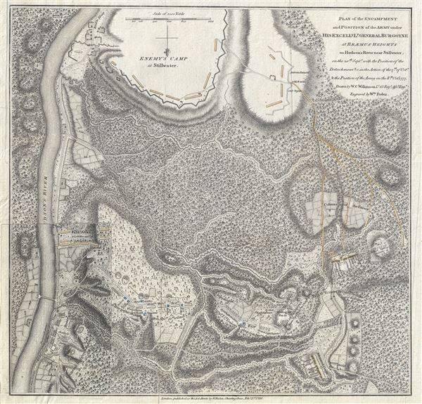

 fought two failed battles in an attempt to break out. Thus trapped by superior American forces, with no relief in sight, Burgoyne surrendered his entire army on October 17. His surrender, says historian Edmund Morgan, 'was a great turning point of the war, because it won for Americans the foreign assistance which was the last element needed for victory.'
Burgoyne defends his actions in the campaign that led to the disaster at Saratoga. He proves in this work that his army was half the size he had demanded, and was badly provided for. The work is one of the best sources on the campaign.
William Cumberland Wilkinson (1756 - January 6, 1802) was an Irish officer in the British Army. He was born in Dublin to Reverend Thomas Wilkinson and Marguerite Susanne Maret de la Rive. Wilkinson was a talented officer that served as a Captain-Lieutenant and military engineer in the 62nd Foot Regiment under British General John Burgoyne during the American Revolutionary War. Wilkinson, like all of Burgoyne's officers surrendered at the Battle of Saratoga. He is best remembered in cartographic circles for completing a series of maps illustrating the disastrous Saratoga Campaign while in captivity. In 1780 Wilkinson was given a special disposition by his American captors to return to Ireland. He died in Belfast in January of 1802. More by this mapmaker...
William Faden (July 11, 1749 - March 21, 1836) was a Scottish cartographer and map publisher of the late 18th century. Faden was born in London. His father, William MacFaden, was a well-known London printer and publisher of The Literary Magazine. During the Jacobite Rebellion (1745 - 1746), MacFaden changed his family name to Faden, to avoid anti-Scottish sentiment. Faden apprenticed under the engraver James Wigley (1700 - 1782), attaining his freedom in 1771 - in the same year that Thomas Jefferys Sr. died. While Thomas Jefferys Sr. was an important and masterful mapmaker, he was a terrible businessman and his son, Jefferys Jr. had little interest building on his father's legacy. MacFaden, perhaps recognizing an opportunity, acquired his son a partnership in the Jefferys firm, which subsequently traded as 'Faden and Jefferys'. Jefferys Jr. also inherited Jefferys Sr. title, 'Geographer to the King and to the Prince of Wales'. With little interest in cartography or map publishing Jefferys Jr. increasingly took a back seat to Faden, withdrawing completely from day-to-day management, although retaining his finical stake, by 1776. The American Revolutionary War (1775 - 1783) proved to be a boomtime for the young 'Geographer to the King', who leveraged existing materials and unpublished manuscript maps to which he had access via his official appointment, to publish a wealth of important maps, both for official wartime use and for the curious public. This period of prosperity laid financial underpinning for Faden, who by 1783, at the end of the war, acquired full ownership of the firm and removed the Jefferys imprint. In 1801, he engraved and published the first maps for the British Ordnance Survey. By 1822, Faden published over 350 maps, atlases, and military plans. He retired in 1823, selling his places to James Wyld Sr. Faden died in 1836. Learn More...
Copyright © 2024 Geographicus Rare Antique Maps | Geographicus Rare Antique Maps
This copy is copyright protected.
Copyright © 2024 Geographicus Rare Antique Maps