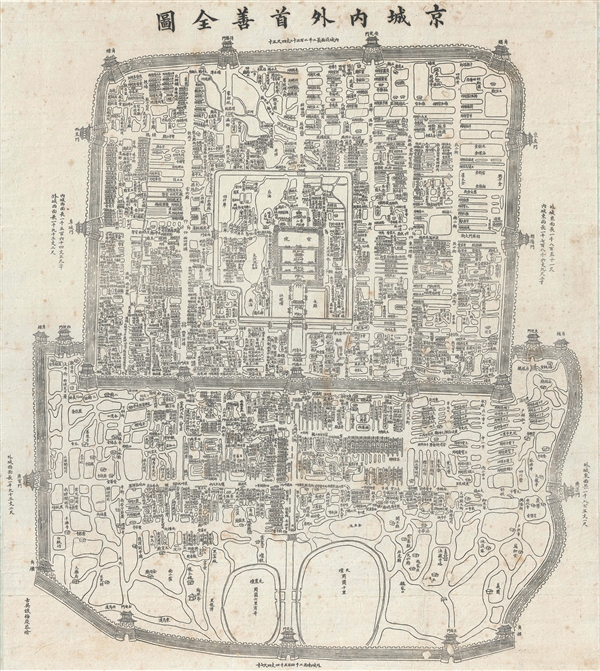
An exceptional c. 1867 Chinese issue Qing Dynasty Map of Beijing or Peking, China. This map details the Qing Dynasty walled city of Beijing. Important buildings, as well as with City and Forbidden City walls, are drawn in profile – a very traditional Chinese approach. In some cases, the dynasty in which important buildings were constructed is noted, so in essence this map covers Beijing's history over three Imperial Dynasties, the Yuan, the Ming, and the Qing.
This map may look familiar to some. In 1900, following the Boxer Rebellion, Japanese occupiers reissued this map with Japanese, and sometimes English or German, overprinting illustrating various zones of occupation. That map (
Boxer Rebellion Map), issued in 1900 is cartographically similar, since it appears to have been based upon the same plate, but the overprinting makes it a very different map. The Chinese original, offered here, printed roughly 30-35 years earlier, is far rarer and is uncommon outside of institutional collections in China.
In addition to illustrating the political events following the Battle of Beijing, the map is also interesting geographically, naming numerous streets and avenues as well as many
Hutong - traditional alleyways associated with
siheyuan or traditional courtyard residences. Many of these have vanished today, making this an exceptional record of 'Old Beijing' on the cusp of change.
Very good. Some repaired wormholes. Backed on archival tissue for stability. Some soiling.