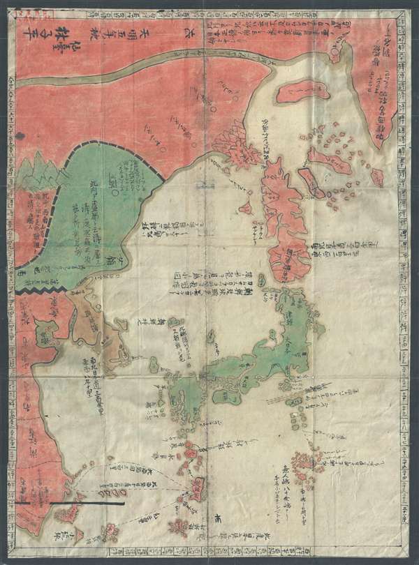
A banned and controversial map, this is the is the rarest and most important of the five c. 1785 maps issued by Hayashi Shihei. The map's title roughly translates to 'Illustrated General Route Map of the Three Countries.' The three countries, in this case, refer to the three nations bordering Japan: Yezo (Hokkaido), Korea, and the Ryukyu Kingdom (Okinawa). In modern terms, it covers from the Sea of Okhotsk and the southern tip of Kamchatka south as far as Taiwan and the Ogasawara Islands, including the modern-day countries of Japan and Korea, as well as parts of China and Russia.
Shihei's map is an intrinsically Japanese production, and for this reason, it is as controversial today as when it was first issued, c. 1785 – although for different reasons. Today, it is significant because it includes the disputed Dokdo Islands (Takeshima / Liancourt Rocks) definitively defined as Korean territory (朝鮮ノ持ニ). These islands are a current point of diplomatic contention between Japan and South Korea, with both claiming sovereignty by historical precedent – which is why this map is significant. Some early maps and other records identify the islands as Japanese, others as Korean. What makes this issue even more complex is that historically the islands were somewhat unimportant and were not consistently mapped using the same nomenclature. So, while many early maps, issued by Korean, Japanese, and foreign publishers, do identify the islets, they frequently different names and it is not always completely clear that the islands shown are in fact the Dokdo / Takeshima / Liancourt archipelago. Which is why this map is so significant. The fact that Shihei's map, being essentially Japanese, recognizes Korean sovereignty over the islets has been aggressively leveraged by Korean authorities to buttress their claims.
When this map was initially published, c. 1785, it was also problematic. Then it was one of the 5 maps prepared to illustrate Hayashi Shihei's
Sangoku Tsuran Zusetsu (Illustrated General Survey of the Three Countries). Shihei's work advocated for gathering intelligence about foreign lands for the defense of Japan, but was banned by the Tokugawa Shogunate as contrary to its isolationist Sakoku (鎖国) or 'Closed Country' policy. Under the Tokugawa censure, almost all the original woodblock printed versions of
Sangoku Tsuran Zusetsu were collected and destroyed. Nonetheless, Shihei's work survived and manuscript copies of his maps began to circulate in learned Japanese circles. Today, few examples of Shihei's maps survive, most only in manuscript form, as here.
Despite numerical marks along the borders in Kanji identifying longitude and latitude, this map is neither scientific nor drawn to scale. At the time of publication, there were other cartographically superior maps of the region, in particular Nagakubo Sekisui's (1717 – 1801) 1779
Kaisei Nihon Yochi Rotei Zenzu (Revised Route Map of Japan /改正日本輿地路程全圖). Compared to Sekisui's map, Shihei's map is imprecise and not accurately scaled – which is why some of the geography is initially difficult to interpret. Even so, as noted on the map, geographical accuracy was not Shihei's goal, rather it is intended to
…show the geographical relations between Japan and the neighboring countries such as Korea, Yezo, Sakhalin, Kamchatka, and Sea Otter Island [Urup].
Before Shihei, Japanese cartographers paid little attention to the lands beyond their borders. But, by the late 18th century Japan was beginning to see increased incursions upon its territory by Russian and Dutch powers, as well as aggressive missionary activity. Shihei was prescient in recognizing that Japan's isolation, which would last another 80 years or so, was untenable in the face of rising global powers.
This map is scarce. As noted previously, it is the rarest and most significant of Shihei's five maps, providing not only a general overview of the region, but also addressing significant current political issues. It is an important piece for any collection focusing on the Liancourt Islands dispute or early Japanese mapping of the greater East Asia region.
Cartographer
Hayashi Shihei (林 子平; August 6, 1738 - July 28, 1793) was a Japanese military scholar, political theorist, and retainer of the Sendai Domain. His name is sometimes read (according to the Sino-Japanese reading) as Rin Shihei. Shihei was deeply concerned with the rise of western military and naval power. In particular he saw Russia's expansion into East Asia as a long term threat to Japanese sovereignty. He lobbied the Tokugawa Shogunate for a strengthening of Japan's defenses and advocated supplementing traditional Samurai training with courses in Western military science. In particular he expressed concerns with the traditional role of the samurai as an independent warrior and stressed teamwork exercises, or choren. He published several important books, including the 1791 Kaikoku Heidan (i.e. Discussion concerning military matters of a maritime nation and the 1786 Sangoku Tsuran Zusetsu (Illustrated Description of Three Countries). This later work included five important maps illustrating Japan, Korea, and the Ryukyu Islands, including Taiwan. Since his work was published without authorization from the bakufu (government), and criticized the Shogun's commerce with foreign powers, Hayashi fell out of favor. Most of his works were subsequently seized and, along with their original woodblock printing plates, destroyed. Consequently, most surviving examples of the five Hayashi Maps are manuscript, copied by hand and handed down in secret from generation to generation. Eventually a copy of Sangoku Tsuran Zusetsu was taken to Siberia, translated into French, and published in Paris in 1832. Hayashi's legacy was thus preserved and, together with Takayama Hikokuro and Gamo Sanbei, he is remembered as one of the "Three Excelling Men of the Kansei Period" (Kansei no san-kijin). More by this mapmaker...
Source
Shihei, H., Sangoku Tsuran Zusetsu, 1785.
Shihei's Sangoku Tsuran Zusetsu describes Joseon Korea, the Ryukyu Kingdom, and Hokkaido. It was one of the first Japanese works to relate Japan to its neighbors and as such was banned by the Edo government in 1792. Almost all of the original woodblock printed versions of Sangoku Tsuran Zusetsu were thus collected and destroyed. Nonetheless, world of Shihei's work got out and manuscript copies of his maps began to circulate in learned Japanese circles. Today, Shihei's work appears primarily in manuscript with original woodcut examples being exceedingly scarce. An example of this work eventually found its way to Europe, where it was published in by Julius Klaproth (1783-1835).
Very good. Some wear on original fold lines. Color oxidization. Even overall toning.
OCLC 69222825.