This copy is copyright protected.
Copyright © 2024 Geographicus Rare Antique Maps
1963 Bullock Pictorial Historical Map of England and Wales
EnglandWalesHistorical-bullock-1963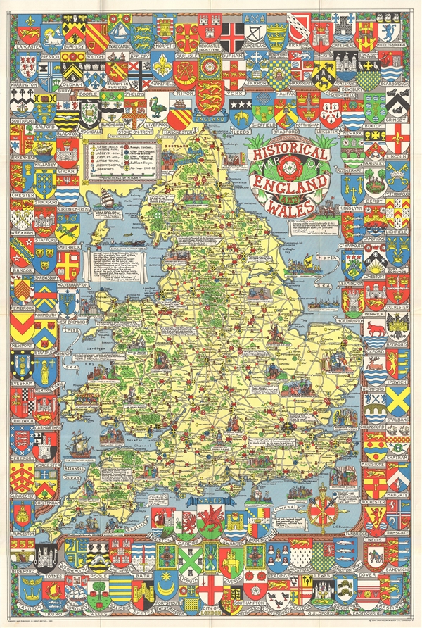

Leslie George Bullock (March 12, 1895 – November 29, 1971) was an English civil servant and cartographer active London during the middle part of the 20th century. Bullock was educated at the Alleyns School of Dulwich. After his schooling he took work with the Union Assurance Company with whom he trained as a fire surveyor. When World War I broke out he joined the Territorial Army. After the war he took work with the Port of London, where he remained until about 1932, when he was transferred to Scotland. Bullock enjoyed visiting London where he felt the truest way to experience the city was by riding the bus or talking a walk, where he would notice and appreciate little vignettes of life. This idea transferred to his cartographic designs, which are defined by small slice-of-life vignettes. All of his cartographic work was published by the firm of John Bartholomew. His most notable maps are his Children's Map of London, his historical maps of England, Scotland, Ireland, and Wales, his city plan of Glasgow, and his United Nations Map of the World. More by this mapmaker...
The Bartholomew Family (fl. c. 1810 - 1920) is clan of map publishers active in London through the 19th century. They represent one of the great names in British cartography. The cartographic story of the Bartholomew family begins with George Bartholomew (January, 8 1784 - October 23, 1871, active from 1797), an engraver in the employ of the Daniel Lizars firm of Edinburgh. George was the first of six generations in the Bartholomew map-making dynasty. It was his son, John Bartholomew Sr. (1805 - April 9, 1861) who ultimately founded John Bartholomew and Sons in 1828. The John Bartholomew firm produced thousands of maps and rose to become one of the largest and most prolific cartography firms in Scotland. John Sr. was succeeded by his son, also John Bartholomew Jr. (1831-93). John George Bartholomew (1860-1920), son of John Bartholomew (1831-93) took control of the firm at its height. John George was a charter member of the Royal Scottish Geographical Society and supported the creation of a National Institute of Geography - a good idea that never took off. John George is also reliably attributed to be the first to bring the term "Antarctica" into popular usage as a denominator for the Southern Continent. In recognition of his work, John George was awarded a warrant from the king and often used the title "Cartographer to the King" on his imprint. Among his friends and admirers he was referred to as the "Prince of Cartography". John (Ian) Bartholomew (1890 - 1962) continued the family business and oversaw publication of the Times Survey Atlas of the World in 1922 and the Mid Century Edition of the Time Atlas of the World from 1955 - 1960. John Christoper Bartholomew (1923 - 2008) continued the family business into a fifth generation and was fascinated by the natural sciences. He spearheaded the publication of many of the most detailed and popular maps of the last century. His brother Robert, a trained printer, became production director. Another brother, Peter, an accountant, started as a managing director and eventually became executive chairman. The John Bartholomew firm has been part of the HarperCollins family of publishers since 1989. The vast archive of maps and atlases produced by the Bartholomew family has since been transferred to the National Library of Scotland where it is currently in the cataloguing process. Learn More...
Copyright © 2024 Geographicus Rare Antique Maps | Geographicus Rare Antique Maps
This copy is copyright protected.
Copyright © 2024 Geographicus Rare Antique Maps