This item has been sold, but you can get on the Waitlist to be notified if another example becomes available, or purchase a digital scan.

1884 Drew Pocket Map of Florida

Florida-drew-1884
$1,500.00
Drew's New Map of the State of Florida Showing the Townships by the U. S. Surveys, the Completed & Projected Railroads, the Diffferent Railroad Stations and Growing Railroad Towns.  The New Towns on the Rivers and interior and the New Counties up to the Year 1884. - Main View
Processing...

1884 Drew Pocket Map of Florida

Florida-drew-1884

The only 19th century pocket map of Florida actually published in Florida!

Title


Drew's New Map of the State of Florida Showing the Townships by the U. S. Surveys, the Completed & Projected Railroads, the Diffferent Railroad Stations and Growing Railroad Towns. The New Towns on the Rivers and interior and the New Counties up to the Year 1884.
  1884 (dated)     25 x 26 in (63.5 x 66.04 cm)     1 : 1140480

Description


An extremely scarce and important map of Florida drawn by Horace Drew in 1884. This highly uncommon map, the earliest known example of which was issued in 1867, is considered to be the only pocket map of Florida actually printed in Florida. The first edition of this map was printed by Columbus Drew from his offices in Jacksonville Florida and subsequently updated in an unknown number of editions into the 1880s. This example was printed by Horace Drew, son and successor to Columbus. It reflects the rapid and hopeful development of Florida through the middle and late 19 century, with numerous railways, roads, and canals noted.

Of particular note is the Lucie Canal, shown here leading from Lake Okeechobee to the Atlantic. This canal was part of a plan, supported by Drew, to drain the Everglades via a series of well placed water channels. Fortunately the Lucie canal was never built and the unique Everglades biosphere has been preserved for us to enjoy today.

Also of interest is the extensive notation in the lower left quadrant regarding the Florida Land Survey. Even in the late 19th century much of Florida remained federally administrated Public Land. It was the work of the Florida Land Survey, upon which this map is based, to plat out the land for sale to settlers. Drew's notations explain the process and how do identify land available for purchase. Drew additionally notes the sites of various important battles during the Seminole Wars.

Considered the Holy Grail of 19th century Florida cartography, this map is a must for any serious collection focusing on the American Southeast. Dated and copyrighted, 'Entered according to Act of Congress in the year 1884 by Horace Drew, in the office of the Librarian of Congress, at Washington.'

Cartographer


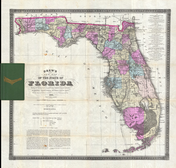
Columbus Drew (January 6, 1820 - July 8, 1891) was a Florida lawyer, politician, writer, bookseller, publisher, and printer active in the mid to late 19th century. Drew was born in Virginia and grew up in Washington D.C., earning a law degree. As a young man he worked with Gales and Seaton of the National Intelligencer. By 1847 he was working as an editor of the Whig-leaning American. Before the American Civil War (1861 - 1865), Drew was an ardent Whig. He was enticed to relocate to Jacksonville, Florida in 1848 to edit the Florida-Whig journal Republican. In 1855, Drew established his stationers business - one of the first in Jacksonville. Although as a Whig he opposed both slavery and the succession, when the Civil War broke out he remained loyal to his adopted state and worked for the Confederate cause. Drew moved briefly to Richmond to take a position in the Confederate Treasury Department. After the war he returned to his stationers shop in Jacksonville where he applied for and received a Federal Pardon for working with the Confederacy. In 1876, Drew was called upon to assume the post of state Comptroller. At this time he sold his stationery business to his son, Horace (January 20, 1854 - January 4, 1926), who renamed it 'H. Drew Company'. Shortly thereafter, in 1886, Horace took on his younger brother, William B. Drew, as a partner, renaming the firm 'H. Drew and Brother'. THe name was again changed in 1893, when it was formally incorporated as 'H. and W. B. Drew Company'. This firm still operates as 'Wells and Drew'. Columbus Drew was a leading figure in the development of Florida during the Reconstruction Era following the Civil War. His influence impacted the development of state railways, canals, drainage projects, and other civil works. Cartographically he is best known for the publication of his 1867 New Map of the State of Florida, which, through numerous editions and revisions, chronicles the history and development of the state during a critical period. This map is now extremely scarce in any edition. Horace Drew, who continued to publish an update his father's important map. The Drew family became leading citizens in Jacksonville and today their historic Victorian home enjoys landmark status. Drew is interred at the Old Jacksonville City Cemetery. More by this mapmaker...

Condition


Very good. Minor discolorations along original fold lines. Professionally removed from binder (included) and flattened.

References


Rumsey, 5190.001 (1870 edition). Fitzgerald, 167 (1874 edition). Phillips, (maps) 285 (1874 edition). Library of Congress, Map Division, G3931.P3 1874 .D7 RR 195. Baxter, J. M., Tequesta - An Annotated Checklist of Florida Maps, p. 115.