
1929 Jillson Geological Map of Kentucky (inscribed by Jillson)

Geologic Map of Kentucky.
Presentation issue of foundational Kentuky Geolgical Map.
- Digital Map Information
- Suitable for large format printing
- Full resolution TIFF file
- ICC color profile embedded
- Delivered instantly via download link
Presentation issue of foundational Kentuky Geolgical Map.
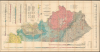
An exceptional presentation issue of Willard Rouse Jillson's 1929 geological map of Kentucky, compiled from the landmark Sixth Kentucky Geological Survey (1925 - 1928). The map provides an extraordinary record of the state's geology and mineral wealth during a formative period of industrial and natural resource development. This presentation example is inscribed to Major Maurice Kirby Gordon (1878 - 1974), an important Madisonville attorney, Kentucky historian, World War I officer, and founding figure of the American Legion whose research focused extensively on western Kentucky coal mining and regional development.A Closer Look
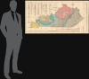
This is a large, meticulously detailed map of Kentucky, focusing on the state's unique geological profile. Color wash indicates geological strata, ranging from Quaternary to Carboniferous to Post-Pennsylvanian. Special indicators show faults, igneous rocks, and more. Mines, mostly asphalt, coal, oil, and gas, are noted, some by the operating company. Tables indicate oil, rock asphalt, fluorspar, natural gas, and coal production and value. Strata profiles appear at the base of the map. Blue lines in various patterns indicate power transmission lines and their associated utility operators.Dedication
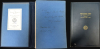
The present example is signed by Jillson and inscribed to Maj. M. K. Gordon of Madisonville, Kentucky. This can only be Major Maurice Kirby Gordon (1878 - 1974), a Madisonville attorney, Kentucky historian, World War I officer, and founding figure of the American Legion who proposed the organization's name at the 1919 Paris Caucus. As a hobbyist historian, Gordon assembled a significant collection of historical material concerning coal mining and the development of western Kentucky - likely including this map. His surviving personal and professional archive, including legal papers, correspondence, photographs, genealogical research, historical manuscripts, and American Legion material, is preserved at Western Kentucky University as the Maurice Kirby Gordon Collection (Mss 306).Sixth Kentucky Geological Survey
Between 1925 and 1928, the Sixth Kentucky Geological Survey, directed by State Geologist Willard Rouse Jillson, greatly expanded the systematic study and mapping of the Commonwealth's geology, topography, and mineral wealth. Its investigations documented Kentucky's coalfields, petroleum and natural-gas deposits, rock asphalt, fluorspar, clays, cement materials, faults, and regional geology, and the compilation of a new statewide base map from detailed topographic, county, and regional surveys provided an essential framework for later geological work. By transforming scattered field observations into authoritative maps and reports, the Survey supported mining, industrial development, infrastructure planning, and scientific research, while establishing a documentary foundation that continues to inform the study of Kentucky's landscape and natural resources.Publication History and Census
This map was compiled by Willard Rouse Jillson based on surveys completed between 1925 and 1928 by R. L. Harrison and W. H. Gill. It was printed by the U.S. Geological Survey. This example is a presentation issue, neatly dissected, mounted on linen, and bound in a gilt-stamped linen binder. The map cover is signed by Jillson and inscribed to M. K. Gordon. Examples of this map are well represented institutionally but scarce to the market.Cartographers
Willard Rouse Jillson (May 28, 1890 - October 4, 1975) was an American geologist, historian, author, and academic best known for his extensive contributions to the study of Kentucky's geology and history. Born in Syracuse, New York, Jillson worked briefly in the Midwest before moving to Kentucky in 1917, drawn by the rapidly expanding oil and gas industry. He joined the faculty of the University of Kentucky in Lexington in 1918 and later taught at Transylvania University beginning in 1947. In 1919, Jillson was appointed State Geologist of Kentucky, eventually serving as director of the Sixth Kentucky Geological Survey; in 1924, he became Commissioner of Kentucky Parks. His long public career also included service as Curator of the State Museum, and in the private sector he helped develop Kentucky oil and gas fields. A prolific scholar, Jillson authored numerous works on Kentucky geology, natural resources, history, and political figures, becoming one of the foremost chroniclers of the Commonwealth's geological and historical heritage. Further Details...
The United States Geological Survey (1878 - Present), aka the U.S.G.S., is a scientific agency of the United States government, which was founded in 1879. USGS scientists study the landscape of the United States, its natural resources, and the natural hazards that threaten it. The organization has four major science disciplines: biology, geography, geology, and hydrology. It is a bureau of the United States Department of the Interior and is the department's only scientific agency. Further Details...
Condition
Excellent. Folds into original linen binder. Dissected and laid on linen by publisher.
References
OCLC 57244300.