
1880 Manuscript Folding Map of Nagoya, Japan and Environs

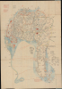
[Nagoya].
Nagoya in the Wake of the Meiji Restoration.
$1,000.00
Choose a Collection:
- Digital Map Information
- Suitable for large format printing
- Full resolution TIFF file
- ICC color profile embedded
- Delivered instantly via download link
This Item
Enquire
Nagoya in the Wake of the Meiji Restoration.
This is a c. 1880 manuscript map of Nagoya, Japan, prepared by an unnamed cartographer. It reflects the city in the aftermath of the Meiji Restoration, which set Japan on a crash course of modernization.A Closer Look
This map covers much of the modern city of Nagoya and its suburban area. Nagoya Castle (御城), the historic core from which the city grew, sits near center. Different districts of the city and rural counties (郡) are indicated. Around the city, various fields (田), wells (井), and other features are labeled. In some areas, more extensive text provides additional information, such as distance tables or similar transportation information relating to nearby villages and provinces (though deciphering the exact meaning of the cursive Kuzushiji script is no easy task). Bridges are illustrated throughout, reflecting the complex network of rivers, small tributaries, and lakes emptying into Ise Bay and eventually the Pacific Ocean; maritime routes across Ise Bay are traced with distances noted, and a maritime table of distances is recorded in red ink at the bottom.Writing in red at top-left may be related to taxation, as it enumerates numbers of villages and rice production in koku (石), a traditional unit of measure. Similarly, a legend at right provides symbols for numbers of villages (村) in a given area. Therefore, it is likely this map had an administrative function, perhaps more than one, as it records water sources, villages, and rice production in considerable detail.
Nagoya Castle
Nagoya Castle is noted, though it was reduced and some of its most valuable possessions were removed soon after the Meiji Restoration in 1868. Indeed, the entire castle was scheduled to be demolished in 1872 before public outcry, including from the German ambassador to Japan, Max von Brandt, prevented it. The castle held particular historical importance in Japan as it had been the home base of Oda Nobunaga (1534 - 1582), who set off the process of Japan's unification in the 16th century. This process was completed at the turn of the 17th century by the Tokugawa Shogunate, which itself was deposed by the Meiji Restoration, making sites associated with the Tokugawa an awkward and potentially subversive presence for the new Meiji regime.Two red-shaded squares with black text appear just adjacent to (east of) and some distance to the north of the castle, respectively. Such red shading, or often pasted-on red slips of paper, was a common way for surveyors to update information on administrative changes or changes to property, especially large, important properties. Indeed, those mentioned here include former district offices and estates (迹) of samurai, indicating a date after the Meiji Restoration. In earlier times, these would have served as outposts and garrisons, outer defenses for Nagoya Castle.
Historical Context
Following the Meiji Restoration, the ruling Owari Domain of Nagoya was dismantled and the city briefly became Nagoya Prefecture before being restructured into Aichi Prefecture in 1872, serving as the prefectural capital. The dissolution of the samurai class required the city to repurpose the land around Nagoya Castle into Imperial Army garrisons and administrative facilities. At the same time, local officials introduced modern municipal systems, including public schooling, standardized taxation, and civil infrastructure. By the 1880s, Nagoya leveraged its rich artisan history to drive early industrialization in central Japan. Local craftsmen adapted traditional Edo-period industries such as ceramics, weaving, and cloisonné enamel into modern export enterprises, fostering key advancements in commercial porcelain production and mechanized textile weaving. The opening of Nagoya Station in 1886 along the newly built Tōkaidō Main Line connected the city directly to Tokyo and Osaka, triggering an influx of commerce and rapid urbanization. This economic transformation culminated on April 1, 1889, when Nagoya was officially incorporated as a city (Nagoya-shi), establishing itself as the premier industrial and transit hub of the Chūbu region.Publication History and Census
This map was prepared by an unnamed cartographer, likely a surveyor in the employ of the local government. As mentioned above, it was likely produced in the early-mid Meiji period, after the samurai and daimyo had been dispossessed of their lands and hereditary privileges; the key information for this dating are annotations to an older, pre-Meiji period map. Presumably, by 1880, the Meiji government would have preferred to produce a printed administrative map with a consistent scale and other distinguishing features of modern cartography, making the present map somewhat mysterious. In any event, as a manuscript map, it is unique.Condition
Very good. Wear on old fold lines. Some wormholing. Attached to original binder.