This item has been sold, but you can get on the Waitlist to be notified if another example becomes available, or purchase a digital scan.

1856 Dodge Wall Map of New Hampshire

NewHampshire-dodge-1856
$1,250.00
Township and Rail Road Map of New Hampshire, compiled from the best authorities with corrections and alteration of town lines from actual surveys, 1856. - Main View
Processing...

1856 Dodge Wall Map of New Hampshire

NewHampshire-dodge-1856

Scarce map of New Hampshire printed in Nashua to illustrate the state's railroad driven industrial boom.

Title


Township and Rail Road Map of New Hampshire, compiled from the best authorities with corrections and alteration of town lines from actual surveys, 1856.
  1856 (dated)     36 x 26 in (91.44 x 66.04 cm)     1 : 380160

Description


A scarce separately issued map of New Hampshire published by J. R. Dodge in 1856. This map is one of the few maps of New Hampshire actually published in New Hampshire, in this case Nashua. Dodge prepared this map to illustrate the rise of railroad lines throughout the state, particularly in the Merrimack River corridor where the fueled a textile boom in Nashua and Manchester. The map's four engraved views highlight the importance of the railroad in the development of New Hampshire's interior. On the right side of the map are the state house in Concord and the harbor town of Portsmouth. Together these two cities represent the pre-industrial centers of New Hampshire's government and economy. As if in contrast to the old guard, the left hand views illustrate the booming industrial centers of Manchester and Nashua, both of which benefited from the rise of railroads to refocus the economy along the Merrimack corridor. Dodge issued this map in four editions. The first edition appeared in 1854. The present example is the second edition, 1856. A subsequent edition appeared in 1860.

Cartographer


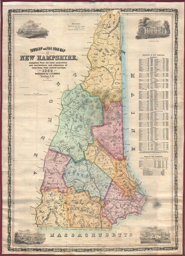
Jacob Richard Dodge (September 28, 1923 - c. 1890) was an American publisher, poet, and journalist. Born in New Boston, New Hampshire, Dodge learned the art of printing in the offices of the Amherst Cabinet, a local newspaper. After graduating from school he accepted a post as a schoolmaster in Mississippi, where he remained for five years, before returning to Nashua, New Hampshire. During this period in Nashua he published his only map, a railroad guide and wall map of New Hampshire. In 1855 he moved to Ohio, where he published the American Ruralist, a regional agricultural newspaper. In 1861 Dodge again relocated, this time to Washington D. C. There he took a position as Senate Reporter for the National Intelligencer. From 1866 to 1878 he worked as Statistician for the Department of Agriculture. In this role he was sent to Europe to represent United States agriculture at the 1873 Vienna Exhibition. Dodge continued to work in statistics with the U.S. Government until the 1880s. It is unclear when Dodge died.3 More by this mapmaker...

Condition


Very good. Professionally restored and backed on fresh linen. Detached from but accompanied by original rollers.

References


Cobb, Maps of New Hampshire, #234. Rumsey 0246.000.