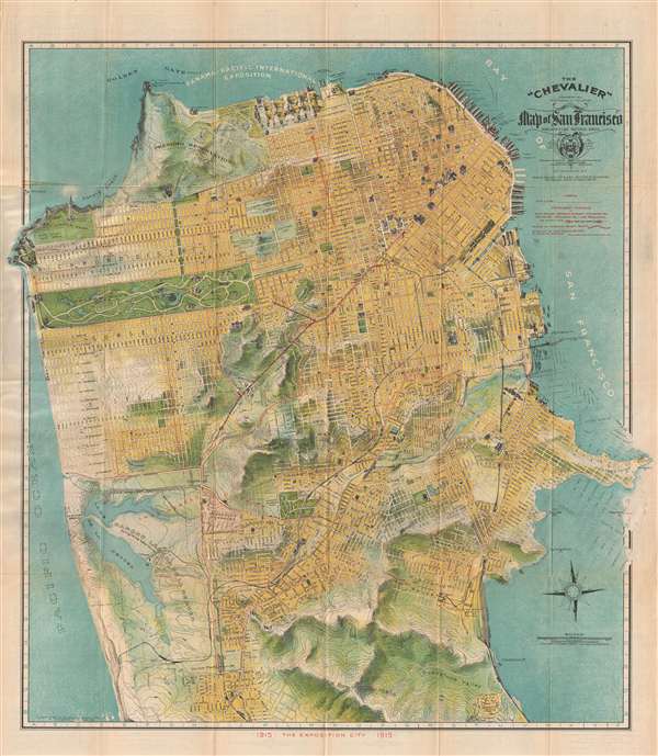
One of the most beautiful early 20th century maps of San Francisco. This remarkable 1915 chromolithographic topographical and pictorial map of San Francisco, California was issued by August Chevalier. Named 'The Chevalier' after its author, the map covers the city of San Francisco from the Golden Gate to Colma and from the Pacific Ocean to San Francisco Bay. The eastern most portion of the map, Hunter's Point, breaks through the border to nearly touch the paper's edge. The city's grid structure is overlaid on a topographical map much as the real-life San Francesco street grid is overlaid on the peninsula's impressively hilly terrain, producing the city's unique topography of steel streets and sharp sudden inclines. Important buildings are shown in profile. Overprinting in red identifies proposed tunnels and trolley lines. Proposed improvements and landfills are ghosted in a t the eastern side of the city surrounding Hunter's Point.
This map was copyrighted in 1912 but issued in anticipation of the 1915 Panama- Pacific International Exposition. The original map upon which it was based was a larger format wall map, also called the 'Chevalier,' published in 1903. The map was subsequently reduced to the present form and reissued in several editions, this being one of the more significant for its association with the Exposition. The map folds into its original paper binder with an art nouveau stamped cover.
Cartographer
August Chevalier (1871 – November 29, 1934) was a French-born American lithographer living and working in San Francisco, California. He came to the United States in 1890. Nothing is known about his early life and education, but he appears to have made his name with the publication of his 1904 work 'The Commercial, Pictorial and Tourist map of San Francisco': Chevalier's wife, Josephine, came to America from France that year, so perhaps the publication of his first map provided the means for bringing her to join him. Chevalier would go on to produce half a dozen plans of his home city, of which his magnificent 1912 topographical map of San Francisco known as 'The Chevalier' is best known. In 1931 he produced a series of 'Aero-Map-Views' of various regions of California, all of which appear to be quite rare. More by this mapmaker...
Very good. Minor verso reinforcement at some fold intersections. Folds into original binder. Stored flat.
Rumsey 5865.002. OCLC 28943362, 953568824.