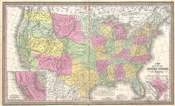
This is an example of Samuel Augustus Mitchell's 1854 map of the United States. Issued shortly following the California Gold rush, this map covers the United States from coast to coast, extending as far north as the Canadian border and as far south as Mexico. Political and topographical features are noted and color coded with elevation rendered by hachure.
Mitchell issued this map during a period of explosive population growth and territorial expansion. As the title suggests this 'New Map' was issued in many editions and updated regularly to reflect the most up to date political developments. The focus of this map is the transcontinental routes that linked the developed east coast cities with the new State of California. Shown are the routes from Fort Smith to Dona Ana, the Fort Smith - Santa Fe Route, General Kearney's Route along the Arkansas River, the Oregon Trail (Oregon Route), Fremont's exploratory route, and the Great Spanish Trail from Santa Fe to Los Angeles. Set in the extreme corners of this map are two insets reflecting the most exciting developments of the time, the partially constructed national Capital at Washington D.C., and the California Gold region surrounding the Sacramento and San Joaquin Valleys.
Cartographically there is much of interest, especially in the western states where territorial development was still in progress. Washington and Oregon extend eastward as far as then the Rocky Mountains. The vast Missouri Territory extends from the Rockies to the Missouri River and south to the Platte River. Utah Territory extends from California to the Rocky Mountains and the Great Basin is recorded as 'Fremont Basin.' New Mexico Territory extends from California to Texas and, though this map was issued in 1854, two year after the event, the Gadsden Purchase is nowhere in evidence. American Indian groups are identified throughout, as are mineral deposits, topographical features, points of interest, and navigable river ways.
This map was prepared by S. A. Mitchell and published by the Philadelphia firm of Thomas Cowperthwait and Co. in the 1854 edition of Mitchell's New General Atlas. Dated and copyrighted, 'Entered according to act of Congress in the year 1850 by Thomas Cowperthwait and Co. in the Clerk's office of the Eastern District of Pennsylvania.'
Cartographer
Samuel Augustus Mitchell (March 20, 1792 - December 20, 1868) began his map publishing career in the early 1830s. Mitchell was born in Bristol, Connecticut. He relocated to Philadelphia in 1821. Having worked as a school teacher and a geographical writer, Mitchell was frustrated with the low quality and inaccuracy of school texts of the period. His first maps were an attempt to rectify this problem. In the next 20 years Mitchell would become the most prominent American map publisher of the mid-19th century. Mitchell worked with prominent engravers J. H. Young, H. S. Tanner, and H. N. Burroughs before attaining the full copyright on his maps in 1847. In 1849 Mitchell either partnered with or sold his plates to Thomas, Cowperthwait and Company who continued to publish the Mitchell's Universal Atlas. By about 1856 most of the Mitchell plates and copyrights were acquired by Charles Desilver who continued to publish the maps, many with modified borders and color schemes, until Mitchell's son, Samuel Augustus Mitchell Junior, entered the picture. In 1859, S.A. Mitchell Jr. purchased most of the plates back from Desilver and introduced his own floral motif border. From 1860 on, he published his own editions of the New General Atlas. The younger Mitchell became as prominent as his father, publishing maps and atlases until 1887, when most of the copyrights were again sold and the Mitchell firm closed its doors for the final time. More by this mapmaker...
Source
Mitchell, S. A., A New Universal Atlas Containing Maps of the various Empires, Kingdoms, States and Republics Of The World, (Thomas Cowperthwait & Co., Philadelphia) 1854.
Very good. Blank on verso.
Phillips (Atlases) 814.