This item has been sold, but you can get on the Waitlist to be notified if another example becomes available, or purchase a digital scan.

1882 Strangers Guide Map or City Plan of Washington D.C. and Georgetown

WashingtonDCGeorgetown2-strangersguide-1883
$75.00
Map of Washington, Georgetown, and Vicinity depicting the Washington Monument 5 years before it opened to the public. - Main View
Processing...

1882 Strangers Guide Map or City Plan of Washington D.C. and Georgetown

WashingtonDCGeorgetown2-strangersguide-1883

Attractive tourist map of Washington D.C.

Title


Map of Washington, Georgetown, and Vicinity depicting the Washington Monument 5 years before it opened to the public.
  1882 (dated)     20.5 x 18 in (52.07 x 45.72 cm)     1 : 25000

Description


This is an 1882 W.H Morrison map of Washington D.C. and Georgetown. The map covers Washington D. C. from Georgetown and Arlington National Cemetery on the left to the eastern branch of the Potomac River on the right and from Rock Creek Church and Cemetery at the top to the 'U.S. Asylum for Insane' on the bottom. It features a detailed depiction of Washington, D.C., block by block. The Smithsonian, the Agricultural Department, the President's House and the Washington Monument (which would not be open until 1888) are all labeled. Georgetown University and Howard University are also labeled. The map depicts several railroads, including both the Metropolitan and Washington branches of the B and O Railroad.

This map was prepared for The Strangers Guide to Washington, Georgetown and Vicinity published by W.H. Morrison in 1883.

Cartographer


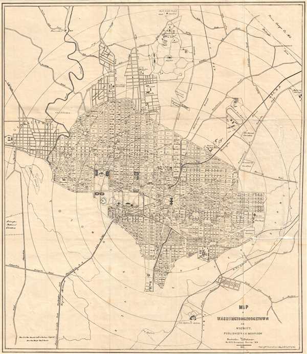
William H. Morrison (fl. c. 1880 - 1910) was a law book specialist, publisher, and stationer active in Washington D. C. during the latter part of the 19th century and early 20th century. He often published with 'O.H. Morrison,' presumably his brother, with whom he inherited the works of William M. Morrison, presumably his father. The Morrisons were best known for their Morrison's stranger's guide to the City of Washington and its vicinity, published between the 1840s and 1890s.

Morrison was described thus by his contemporaries:

W. H. Morrison is, in the usual term, a hustler, being his own solicitor. By scouting surrounding towns is a fast building up a good trade. His long experiences in the line and extensive acquaintance give him at once a good position in the trade. -The American Stationer Feb 4, 1892.
Morrison printed maps and Guides to Washington D.C. as well acted as a bespoken stationer and a government printer. Among other things, Morrison was a strong advocate of paper currency - no doubt hoping to get an edge on the business of printing money. He maintained a storefront at 475 Pennsylvania Ave, N.W. More by this mapmaker...

Source


Morrison, W. H., Stranger's Guide, (Washington D.C.) 1883.    

Condition


Average. Map has been backed on archival tissue. Map has been repaired along right side and exhibits some loss along original tear. Exhibits some displacement along damaged section.

References


Bryan, W. B., Bibliography of the District of Columbia (Washington D.C.), p. 121.