Title
Western Africa.
1835 (undated)
17 x 21 in (43.18 x 53.34 cm)
1 : 8110000
Description
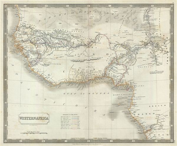
This is a beautiful map of western Africa from Sidney Hall's extremely scarce 1835 New General Atlas. It covers the entirety of western coast of Africa from River Zaire or Congo west through the Slave Coast, Gold Coast, Ivory Coast, Guinea, and north past the Grain Coast and Senegambia as far as the Bank of Arguin (Banc d'Arguin). Hall names numerous African tribes and nations throughout, and offers other interesting cartographic annotations such as the 'source of the Niger River according to Mr. Park' (Mungo Park, whose exploratory route is noted) and another 'source of the Niger River according to Major Laing' near the Mountains of Loma. It offers interesting inland detail along the Niger River as far east as Timbuktu, with the 'supposed direction of the Quorra or Niger' rendered somewhat correctly emptying into the Gulf of Guinea. West of Timbuktu the city of Walet (said to be larger than Timbuctoo) is also identified. The continent is partially bisected by the dramatic and mythical Mountains of Kong, which, based upon the explorations of Mungo Parks, were presumed to be the southern barrier to the Niger River valley. Hall to his credit reduces the Kong mountain range considerably over the expansive range depicted in earlier English maps by Thomson, Pinkerton, and others. To the east Lake Tchad (Chad) is well mapped. The supposed course of the River Shary is also noted just to the south of Lake Chad.
This region was particularly important in the early 19th century as the source of most African slaves imported to the New World. Even so, at the time this map was made, the slave trade, thriving since the 5th century was rapidly diminishing due to decreased demand for slaves in the New World, the British outlawing of slavery in 1808, and subsequent diplomatic efforts including treaties with over 50 African rulers outlawing the practice. Many African economies adapted by shifting to the export of mineral and agricultural resources, which led to the European scramble for territory, occupying most of the continent by the end of the 19th century. Europe's colonial interests in Africa haphazardly carved up the continent into unnatural territories, often forcing historic enemies into close proximity and leading to social problems that remain to this day.
Sidney Hall's New General Atlas was published from 1830 to 1857, the first edition being the most common, with all subsequent editions appearing only rarely. Most of the maps included in the first edition of this atlas were drawn between 1827 and 1828 and are most likely steel plate engravings, making it among the first cartographic work to employ this technique. Each of the maps in this large and impressive atlas feature elegant engraving and an elaborate keyboard style border. Though this is hardly the first map to employ this type of border, it is possibly the earliest to use it on such a large scale. Both the choice to use steel plate engraving and the addition of the attractive keyboard boarder are evolutions of anti-forgery efforts. Copper plates, which were commonly used for printing bank notes in the early 19th century, proved largely unsuitable due to their overall fragility and the ease with which they could be duplicated. In 1819 the Bank of England introduced a £20,000 prize for anyone who could devise a means to print unforgeable notes. The American inventors Jacob Perkins and Asa Spencer responded to the call. Perkins discovered a process for economically softening and engraving steel plates while Spencer invented an engraving lathe capable of producing complex patters repetitively - such as this keyboard border. Though Perkins and Spenser did not win the prize, their steel plate engraving technique was quickly adopted by map publishers in England, who immediately recognized its value. Among early steel plate cartographic productions, this atlas, published in 1830 by Longman Rees, Orme, Brown & Green stands out as perhaps the finest. This map was issued by Sidney Hall and published by Longman Rees, Orme, Brown & Green of Paternoster Row, London, in the 1835 edition of the Sidney Hall New General Atlas.
Cartographer
Sidney Hall (1788 - 1831) was an English engraver and map publisher active in London during the late 18th and early 19th centuries. His earliest imprints, dating to about 1814, suggest a partnership with Michael Thomson, another prominent English map engraver. Hall engraved for most of the prominent London map publishers of his day, including Aaron Arrowsmith, William Faden, William Harwood, and John Thomson, among others. Hall is credited as being one of the earliest adopters of steel plate engraving, a technique that allowed for finer detail and larger print runs due to the exceptional hardness of the medium. Upon his early death - he was only in his 40s - Hall's business was inherited by his wife, Selina Hall, who continued to publish under the imprint, "S. Hall", presumably for continuity. The business eventually passed to Sidney and Selina's nephew Edward Weller, who became extremely prominent in his own right. More by this mapmaker...
Source
Hall, S., A New General Atlas, with the Divisions and Boundaries, 1835.
Condition
Very good. Original platemark visible. Minor wear along original centerfold. Blank on verso. Minor offsetting.
References
Rumsey 4224.042 (1830 edition). Tooley, R.V., The mapping of Australia and Antarctica, 2nd ed., p. 92-93, no 687. Philips (Atlases) 758. National Library of Australia, 2113921; MAP F 514; MAP NK 10750/1; MAP RM 741; MAP T 687. Ristow, W., American Maps and Mapmakers: Commercial Cartography in the Nineteenth Century, p. 303-09.