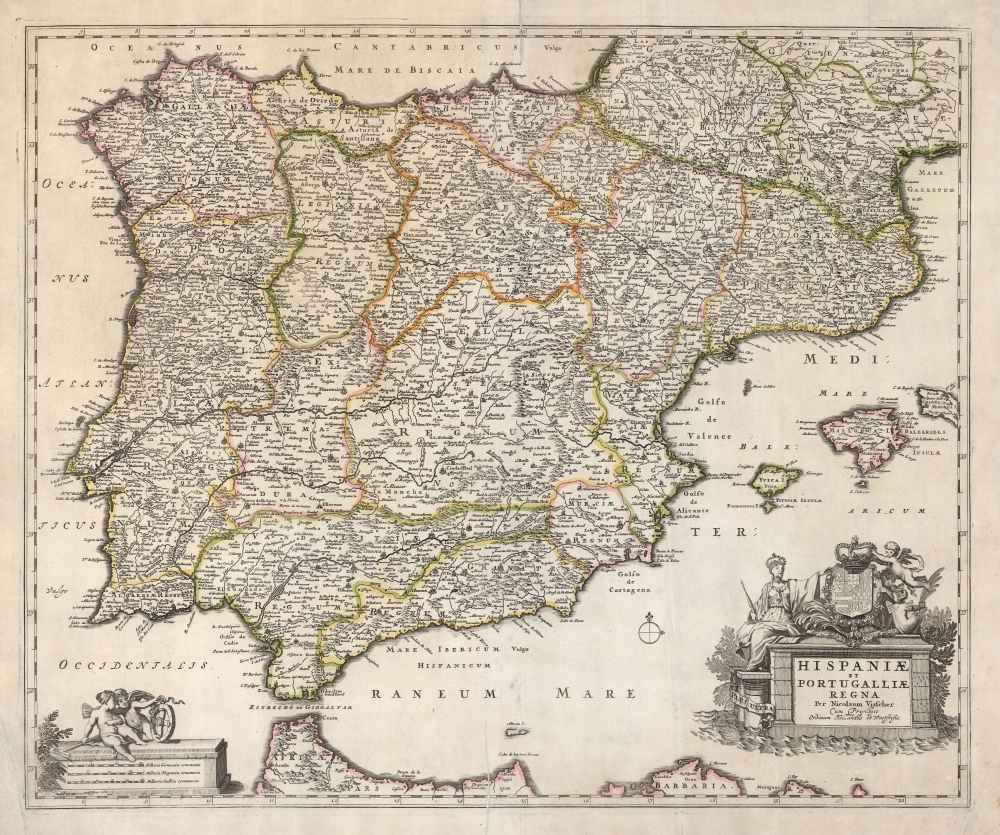
In classing Dutch style, this a first-plate example of Nicolas Visscher's c. 1677 map of Spain and Portugal. The realms are divided into their subordinate kingdoms, with the borders marked in attractive hand color.
State of the Art of the Mapping of Spain
The map encompasses the Iberian Peninsula, including the Balearic Islands and part of the northwest coast of Africa, and Spain's border region with France. It is superbly detailed, and reflects geographic knowledge of the interior of Spain that had only recently begun to emerge. As a notable example, consider in southern Castille the presence of the R. Roydera and the Lagunas de Guadiana. This is one of the earliest cartographic references to the Ruidera Lagoons, a series of Karstic Lakes in the Guadiana Viejo valley, a continuation of the Pinilla River. These lakes are now artificially connected to the Peñarroya Reservoir, and ultimately via canal to the Guadiana River. At the time this map was produced, no such connection existed and the separation of the R. Roydera from the Guadiana River represented an important correction from the maps of the previous century. Earlier maps of Spain do not include these elements, instead showing the lake and lagoons as a southern branch of the Guadiana River. The earliest appearance of the lagoons that we have seen is upon Frederick De Wit's Accuratissima Totius Regni Hispaniae Tabula. If the date we see associated with that map of 1662 is accurate, then that is likely the first printed depiction of the Lagoons, and thus the source for Visscher's map. Nicolas Sanson's 1665 L'Espagne shows the lagoons but does not name them. The fragment of R. Roydera is shown, but retains the name 'Guadiana,' revealing it to be a hasty correction to keep current with the superior De Wit cartography.Beautiful Engraving
The map is embellished with lovely, allegorical engraving. The cartouche depicts Europa, accompanied by a trio of putti displaying the arms of the Spanish Habsburgs. A banner at Europa's feet bears the Spanish motto, 'Plus Ultra'. In the lower left, the scale of miles is displayed. Upon it, two putti play with a cross staff and an astrolabe, a reference to Portugal and Spain's successes in navigation.Publication History and Census
This map was engraved in and around 1677 for inclusion in Visscher's Atlas Minor. Visscher's Atlas Contractus of the same year occasionally contained De Wit's map instead. This is an example of the first plate Visscher engraved of this map: we are aware of only a single state of this plate, which is most easily distinguished from the second plate by its narrow plate-mark, and differences in the engraving of the cartouche. A second plate appears in its first state around 1688. In about 1690, latitude and longitude lines were added, and thereafter a third state was produced adding Pieter Schenk's imprint. Overall, the map appears in many institutional collections. However, the plate and state changes which occur with this map are not well cataloged and so it is difficult to determine an accurate census in OCLC of any specific state.
Cartographer
Nicolaes Visscher II (September 30, 1649 – May 31, 1702) was a Dutch engraver, cartographer and publisher: he was born into the trade, the son of Nicolaes Visscher I and the grandson of Claes Janszoon Visscher. He produced a number of maps to add to the family atlas, as well as for inclusion in other composite atlases. After his death, his wife, Elisabeth, continued the family tradition of mapmaking and publishing. The plates and remaining stock were then sold to Peter Schenk, who reprinted them under his own name. More by this mapmaker...
Source
Visscher, Nicolas II, Atlas Minor, (Amsterdam: Visscher) 1677.
Good. Reinforced with rice paper; centerfold mended with few areas of slight loss. Original outline color.
OCLC 248589798.