This item below is out of stock, but another example (left) is available. To view the available item, click "Details."

Details 1929 Poole Brothers Map of Alaska and Alaska Steamship Company Routes
1929 (dated) $450.00

1917 Poole Brothers Map of Alaska and Alaska Steamship Company Routes

AlaskaSteamship-poolebros-1917
$225.00
When You Think Alaska - Think Alaska Steamship Co. - Main View
Processing...

1917 Poole Brothers Map of Alaska and Alaska Steamship Company Routes

AlaskaSteamship-poolebros-1917

Promotes incredible natural wealth of Alaska and how easy it is to get there!

Title


When You Think Alaska - Think Alaska Steamship Co.
  1917 (dated)     22.5 x 31.5 in (57.15 x 80.01 cm)     1 : 4500000

Description


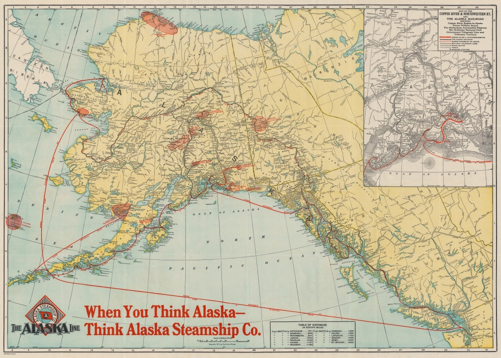
This is a 1917 Poole Brothers map of Alaska promoting the Alaska Steamship Company and their routes. The map covers from the Bering Sea, the Bering Strait, and eastern Siberia to the Yukon Territory and from the Arctic Ocean to Seattle, Washington. Even though it was printed in 1917, one of the goals of this advertisement was the promotion of the vast mineral and other natural resources being exploited in Alaska and the Yukon. The Klondike, Fairbanks, and Nome gold placers are highlighted, as well as the Nenana, Matanuska, and Bering River coal fields. Other highlighted resources include the Point Barrow Oil Field, along with a handful of other oil fields, and the Kennecott copper mines. Mt. McKinley National Park and the U.S. Seal Preserve around the Pribilof Islands are identified using the same symbol, allowing for no distinction in importance between preservation of natural landscapes and the utilization of natural resources.

The two major routes of the Alaska Steamship Company are illustrated in red, the Inside Route, which ventured up the Pacific coast to Skagway, Valdez, and Seward, and the Nome and St. Michael route. Innumerable towns are labeled throughout Alaska, along with mountains and mountain ranges, rivers, islands, bays, and islets. The Copper River and Northwestern Railroad and the Alaska Railroad are depicted both on the central and in an inset map situated on the upper right. The inset map details the route of the Copper River and Northwestern from Seward to Fairbanks and the Alaska from Cordova to Kennecott. The inset map also notes the military telegraph lines, stage routes, and wireless stations. A table of distances from Seattle to thirteen different locations in Alaska is included along the bottom border.

This map was produced by the Poole Brothers Company of Chicago to promote the Alaska Steamship Company.

Cartographer


Poole Brothers (fl. c. 1880 - 1968) were a Chicago based firm active in the late 19th and early 20th century with an initial focus on promotional railroad maps. Poole Brothers was founded by George Amos Poole, one of the original four partners in the firm that would become Rand McNally, and his brother William H. Poole. Poole started his own firm, Poole Brothers, as a direct competitor to Rand McNally for the lucrative railroad business. Like many of its competitors, Poole Brothers maintained an office on Chicago's Printer's Row (downtown Loop district). Nevertheless, the two firms, along with Cram and Company, seem to have come to an accord, at least with regard to price-fixing, for which they were cited by the Federal Trade Commission in 1948. Their earliest known work is an 1880 map of Yellowstone National Park. Afterward they went on to produce a vast range of maps and other print products including tickets, cards, coupons, and restaurant menus. In time Poole Brothers merged with Newman-Randolph, which was then acquired by the American Can Company in the early 1960s. The American Can Company liquidated its printing concerns later in the same decade. More by this mapmaker...

Condition


Very good. Laid down on archival tissue for stability. Blank on verso.

References


OCLC 309402763.