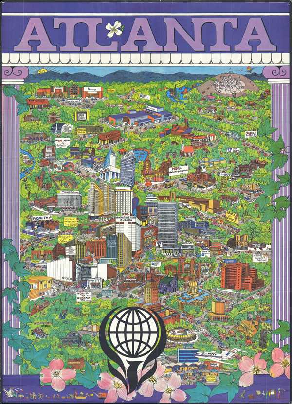
This is an extremely rare and creative 1972 Trans Continental Cartographers pictorial map of Atlanta. The map depicts the city of Atlanta in a nonconventional manner, creating a map that is meant more for decoration than for practical use. Several famous Atlanta landmarks are illustrated, including Hartsfield Atlanta International Airport, Atlanta Stadium (the former home of the Atlanta Braves and Atlanta Falcons), and Emory University. Several not-so-famous locations are also noted, including Carol Waltz Interior/Antiques, the Coach and Six Restaurant, and two different shopping malls. Nationwide chains, such as United Airlines, Sears, Budget Rent-a-Car, and Six Flags (Six Flags Over Georgia) are depicted as well. It is possible that these companies were solicited for subscriptions, and their brand was featured accordingly. Other, more humorous, aspects of the map are thrown in sporadically. For example, some of the trees have faces, and a few of them comment on the goings-on around them. The people placed around the map offer comment as well. The Confederate Memorial Carving at Stone Mountain Park is also depicted.
We were unable to locate any examples of this map in institutional collections, making it a unique and entertaining addition to any collection. This map was published by Trans Continental Cartographers of Vancouver, British Columbia in 1972. They published several pictorial maps of American and Canadian cities, including Boston, San Francisco, Kansas City, New Orleans, Minneapolis, and Vancouver. It was distributed by A.A. Sales Inc. of Seattle, Washington.
Cartographer
Transcontinental Cartographers Limited (fl. c. 1971 - 1972) was a publishing company based in Vancouver, British Columbia. The company published several pictorial maps of American and Canadian cities, including Boston, San Francisco, New Orleans, Kansas City, Atlanta, Minneapolis, and Vancouver. It appears that they subscribed to the ‘subscription model’ of cartography, by accepting payment from companies to feature their businesses in their maps. Their maps were distributed by A.A. Sales Inc. of Seattle, Washington. More by this mapmaker...
Very good. Expert repair top center. Blank on verso.