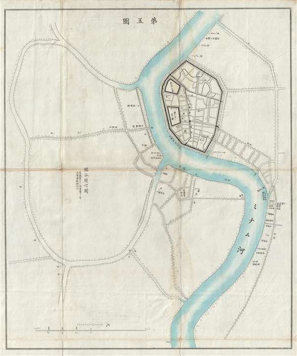
A scarce Meiji 8, 1875 Japanese issue plan or map of Bangkok, Thailand. Centered on the Chao Phraya River, the map covers the 'S' shaped bend in the river where the original royal fortifications of Bangkok stood. Some of these old fortifications remain in place today. Today, as then, this area comprises, on the East side of the river, the Grand Palace, Wat Po, Banglamphu, and Bangkok's Chinatown. On the west side, it extends to include Bangkok Yai, or the area contained by the elaborate canal system between the Bangkok Yai and Bagnkok Noi canals. Numerous locations are noted, especially within the walled royal compound and along the river in Chinatown.
This map appears to be based upon a survey completed by an American missionary, but who this may have been is unclear. From our research, they possibly refer to James Curtis Hepburn, an American Missionary active around this time in Bangkok. It was prepared to illustrate an extremely rare Meiji Era Japanese travelogue describing a voyage to Thailand or Siam. We have identified only two other examples of this map located in the archives of the Waseda University Library, Tokyo; the Kyoto University Library, Kyoto.
Source
Siamese Kikouzu (暹羅紀行図 ), Tokyo : Kōbush) 1875.
Very good. Toning and wear on original fold lines. Minor water stain. Else clean.
OCLC 838714642. Waseda University Library, 292.37038 njb / 8. Kyoto University Library, 1960818789.