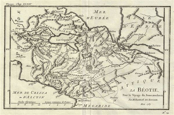
This is an attractive 1787 map of Boeotia, one of the regions in Ancient Greece. Cartographically based on an early map by D'Anville, this map is centered on Thebes and details the ancient region's important towns and cities. The map also attempts to illustrate events associated with the Battle of Plataea. The battle of Plataea occurred in 479 BC and was the last battle in the second Persian invasion of Greece. It took place near the city of Plataea in Boeotia, and was fought by an alliance of the Greek city-states, including Sparta, Athens, Corinth and Megara, against the Persian empire of Xerxes I. The map features Mount Cithaeron, where the tide of the battle turned. The battle concluded with a large portion of the Persian army trapped in their camp where they were slaughtered, essentially brining the invasion to a close. Prepared by M. Barbie de Bocage in 1787 to illustrate the Travels of Anacharsis.
Anacharsis was a Scythian philosopher who travelled from his homeland on the northern shores of the Black Sea to Athens in the early 6th century BCe. Apparently he made a great impression on the Greeks, who considered him a forthright, outspoken 'barbarian. He is considered a forerunner of the Cynics.
Cartographer
Jean Denis Barbie du Bocage (1760 - 1825) and his son Jean-Guillaume Barbie du Bocage (1795 - 1848) were French cartographers and cosmographers active in Paris during late 18th and early 19th centuries. The elder Barbie du Bocage, Jean Denis, was trained as a cartographer and engraver in the workshops of mapmaking legend J. B. B. d'Anville. At some point Jean Denis held the post of Royal Librarian of France and it was through is associations with d'Anville that the d'Anville collection of nearly 9000 maps was acquired by French Ministry of Foreign Affairs. The younger Barbie du Bocage, Jean-Guillaume, acquired a position shortly afterwards at the Ministry of Foreign Affairs and, in time, became its head, with the title of Geographe du Ministere des Affaires Etrangeres. More by this mapmaker...
Source
Barbie du Bocage, J. D., Recueil de Cartes Geographiques Plans, Vues, et Medailles de l'Ancienne Grece, Reelatifs au Voyage du Jeune Anacharsis., (Paris, Chez Sanson et Compagnie), 1791.
Very good. Original platemark visible. Original centerfold. Blank on verso. Dark clean impression.