This item has been sold, but you can get on the Waitlist to be notified if another example becomes available, or purchase a digital scan.

1687 Van Keulen Map of Carolina, Georgia, Virginia, and Florida

Carolina-vankeulen-1687
$1,750.00
Pas Kaart van de Kust van Carolina tusschen C de Canaveral en C Henry. - Main View
Processing...

1687 Van Keulen Map of Carolina, Georgia, Virginia, and Florida

Carolina-vankeulen-1687

One of the most decorative early nautical charts of the American Southeast.

Title


Pas Kaart van de Kust van Carolina tusschen C de Canaveral en C Henry.
  1687 (undated)     21 x 23.5 in (53.34 x 59.69 cm)     1 : 1749000

Description


Among the most scarce and decorative Dutch nautical charts of the American southeast, this is Johannis Van Keulen's and C. J. Vooght's 1687 maritime map of the Virginia, Carolina, Georgia and Florida coasts. Oriented to the west (with north to the right), this map covers from the entrance to the Chesapeake Bay southwards, along the eastern seaboard, as far as Cape Canaveral, Florida. Like most nautical charts, this map focuses on the coast line and offers limited inland data. The cartographer, C. J. Vooght, has based this map on various unpublished and unknown sources; however, he appears to reference the c. 1590 maps of John White and Jacques Le Moyne for place names in Virginia and Carolina, respectively. Spanish place names are used for several of the capes, no doubt referencing said 'unknown' sources. The region between Cape Hatteras and the mouth of the Chesapeake Bay features numerous depth soundings.

As this map was issued most of this region was disputed between the colonial powers of Spain, entrenched in St. Augustine Florida, and the english who had been slowly moving into the Ablemarle Sound and Cape Fear River region from their colony in Virginia. Carolina received its official grant from the British Crown in 1663 – the southward expansion was not only a territorial expansion but a move that positioned the British colonies to more actively trade with the lucrative West Indies colonies. The southernmost British settlement at the time was Charleston, which appears on the west bank of the Ashley River (here called by the Spanish name, Rio Grande) in both the main map and the inset in the upper right quadrant. Charlestown was founded by just a few years earlier, in 1670 by Anthony Ashley-Cooper, one of the Lords Proprietors, to become a 'great port towne', a destiny which it fulfilled.

There is some confusion regarding the original publication date of this map. An english edition appeared in 1682 which was apparently based on an earlier Dutch edition. The fact the Van Keulen does not include updated information from the 1682 Second Lords Proprietor's Map, suggests that the two maps may have been published simultaneously. The present example corresponds to the second state, 1687, identifiable by the no. 18 set in the lower left corner. Uncolored as issued. The prominence of the Van Keulen name caused this chart to be exceptionally influential and a primary source for charts of the region for the subsequent 50 years.

CartographerS


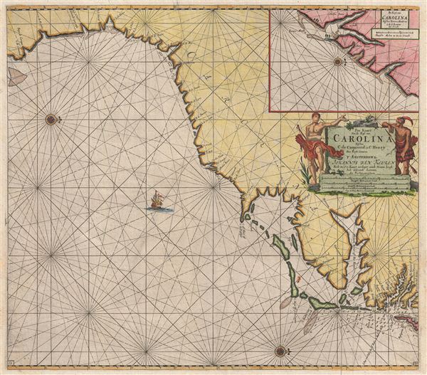
Johannis Van Keulen (1654 – 1715) was a Dutch cartographer active in Amsterdam during the late 17th century. Keulen was the son of Lucas van Keulen. Keulen's firm, β€˜In de Gekroonde Lootsman' (In the Crowned Pilot), was founded in 1678 and registered with the Amsterdam bookseller's guild as 'Cross staff-maker and bookseller'. The cross-staff is a nautical instrument used to determine latitude. Two years later, in 1680, they obtained a patent from the States General of Holland and West Friesland to publish nautical charts and atlases. Together with his partner, the cartographer Claes Janz Vooght, Van Keulen published numerous atlases and nautical charts, including the Zee Atlas and Nieuwe Lichtende Zee-Fakkel. The term, Zee-Fakkel translates to 'Sea Torch.' It was a massive five volume atlas containing more than 130 nautical charts. The Zee-Fakkel established the Van Keulen firm as the pre-eminent maker of Dutch sea charts in the late 17th and early 18th century. In 1714, one year before Johannis Van Keulen death, his son, Gerard van Keulen (1678 - 1726), took charge. Gerard continued to update and republish the Zee-Fakkel until his own death in 1726. The firm was later passed on to Gerard's son, Johannes II Van Keulen (1704 - 1755), who significantly updated the atlas, especially with regard to Asia, issuing the 1753 4th Volume, known as the 'Secret Atlas'. The final editions of the atlas were published by Gerard Hulst van Keulen (1733 - 1801), Joannes II's son. The final true Van Keulen edition of the Zee-Fakkel was published posthumously in 1803. It is noteworthy that though ostensibly controlled by the Van Keulen men, it was the Van Keulen widows who maintained and managed the firm in the periods following their husbands' deaths. After the death of Gerard Hulst Van Keulen's son, Johannes Hulst Van Keulen, ownership of the family plates and business fell into the hands of the Swart family who continued to publish until the company closed its doors 1885, ending cartographic legacy spanning nearly 207 years. More by this mapmaker...


404 Not Found

Server Error

404

Page Not Found

This page either doesn't exist, or it moved somewhere else.


That's what you can do

Learn More...

Source


Van Keulen, J., De Nieuwe Groote Lichtende Zee-Fakkel, Part IV (Amsterdam) 1687.    

Condition


Good condition. Minor water stain near right and left borders.

References


Cumming, E., The Southeast in Early Maps, 91. Burden, P., The Mapping of North America II: A list of printed maps 1671-1700 589. Koeman, C., Atlantes Neerlandici. Bibliography of Terrestrial, Maritime and Celestial Atlases and Pilot Books, Published in the Netherlands up to 1880, Keu 20B(133). Koeman, C., The Sea on Paper - The Story of the Van Keulens and their 'Sea-torch', 4-26. Brown University, JCB Library, Cabinet Ce682 /1.1. OCLC 51730491.