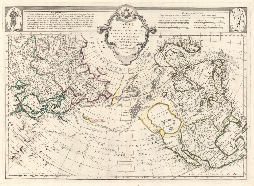
Title
Carte Des Nouvelles Decouvertes au Nord de la Mer de Sud, tant a l'Est de la Syberie et du Kamtchatka, qu'a L'Ouest de la Nouvelle France.
1752 (dated 1750)
18.5 x 25.5 in (46.99 x 64.77 cm)
1 : 21000000
Description
Rare first edition of Joseph Nicolas De l'Isle's extraordinary 1752 map of North America, Siberia, the Arctic, and the North Pacific. J. N. De L'Isle and Buache drew this map to illustrate their speculations on the feasibly of a Northwest Passage. Cartographically this map is a combination of data absconded from the Russian 'Academy of Sciences' and Buache’s speculations on the Northwest Passage. This map is highly significant for its revival of the 'Sea of the West' hypothesis. This is a landmark map in the history of cartography and perhaps the single most influential map of the region issued in the middle of the 18th Century.
When Joseph-Nicholas de L’Isle, younger brother of the better known Guilleme de L’Isle, returned from his tenure at Russian Tzar Peter the Great’s Academy of Sciences he decided to publish a compilation of secret cartographic data obtained from previously unknown Russian expeditions to Kamtschaka and the coast of Siberia. These seminal explorations included the discoveries of Aleksei Ilyich Chirikov (Tchirikow), Nicholas de Frondat, and Vitus Bering, among others. De L’Isle produced a ground breaking and largely accurate mapping of the peninsula of Kamchatka and the coast of northeast Asia - shown here. This he presented in manuscript form to the Paris Royal Academie des Sciences in on the 8th of April, 1750. This date appears on all editions of the map, however, the map was not actually printed in its first edition, first state, as here, until 1752.
De L’Isle contracted J. N. Buache, already a prominent cartographic figure due to his introduction of hachures as a method for displaying elevation on a two dimensional plane, to complete the North American part of the map. Buache used the mythical voyages of Admiral de Fonte, Martin Aguilar, and Juan de Fuca as his cartographic source material. The two sides of this map therefore could not be more heavily contrasted, for the mapping of Asia is largely accurate where the mapping of North America is almost entirely fantastical. This map shows the 'Sea of the West', supposedly discovered by Fuca, as well as the series of lakes, rivers, and canals heading eastward toward the Baffin and Hudson Bays that were purportedly first identified by De Fonte. These include Lac de Fonte, Lac Belle and Lac de Valasco.
The tale of De Fonte' discoveries in the American Northwest are particularly interesting. The De Fonte legend first appeared in a 1706 English publication entitled Memoirs of the Curious. This short-lived magazine published a previously unknown account by a supposed Spanish Admiral named Bartholomew de Fonte. De Fonte is said to have sailed up the Pacific coast of North America in 1640. On this voyage he apparently discovered a series of gigantic lakes, seas, and rivers heading eastward from the Pacific towards Hudson Bay. The De Fonte story relates how, on one of these great inland lakes, he met with a westward bound ship from Boston that must to have come through the Northwest Passage. Today, based upon inaccuracies and falsities, we know the entire De Fonte article to have been a fabrication, however, it set 18th century afire with speculation that a Northwest Passage must indeed exist. Even such luminaries as Benjamin Franklin wrote long defenses of De Fonte. Our map offers an uncommon variant on the De Fonte passage, positioning its western entrada well to the north in order to accommodate the Sea of the West and situating its outlet at the Baffin rather than the Hudson Bay.
By far the most interesting aspects of this map deal with De L'Isle and Buache's treatment of the largely unexplored Pacific Northwest. A magnificent sea, called the Sea of the West or in this case the Baye de L'Ouest, occupies the greater part of the northwestern part of the continent. This body of water, alternatively called the Sea of the West or Mer de l'Ouest, was speculated by Philippe Buache and De l'Isle in the early 18th century based upon wishful thinking, American Indian stories, and the somewhat questionable 16th century explorations of Juan de Fuca. Here Buache gives the Mer de l'Ouest its fullest expression, though he specifically does not connect it to either the factual network of lakes and rivers extending westward form the Hudson Bay or to the speculative De Fonte network just to the north.
On the opposite side of the map, just to the east of Kamchatka there is an unusual body of land reminiscent of the Muller Peninsula, postulated around this time based on sightings of the Aleutian archipelago and their misinterpretation as a single land mass. This supposed island bears a significant resemblance to Gamaland or Compagnie Land as imagined by Sanson c. 1705. A note at the very edge of this land mass claims that it was seen in 1741, suggesting either Vitus Bering or Alexei Chirikov. Both did in fact search for Gama or Compagnie land in this year without significant success. Curiously both Gamaland, the supposed discovery of explorer Jean de Gama, and Compagnie, are also illustrated, well reduced over Sanson's model, just to the east of a malformed Yedo (Yeco) or modern day Hokkaido. In actuality both Gama and Compagnie and presented here reflect preliminary sightings of the Japanese Kuril Islands in 1643 by the Dutch navigators Maerten de Vries and Cornelis Jansz Coen. Vries and Coen were searching for Juan de Gama's discovery which was originally considered to be an island replete with silver and other precious metals.
Along the base of the map the Acapulco to Manila trade route is illustrated according to records dating to the British Baron George Anson's capture of the Spanish treasure galleon Nuestra Senora de Covadonga. The galleon, taken off of Cape Espiritu Santo in 1743 was loaded with silver bullion and, more importantly, charts and maps detailing the routes between Mexico and the Far east used by the Spanish for over 200 years. Knowledge of this route enabled the British navy to disrupt Spanish trade in the Pacific and thus weaken its stranglehold on the Americas. Upon his return to England Anson was hailed as a national hero and made immensely wealthy by his share of the Nuestra’s treasure. The impact Anson's exposure of the secret Acapulco – Manila route on the global economy is emphasized in its inclusion in this French map.
A careful examination of this map also reveals much of De L'Isle's political agenda through his carto-advocacy for French interests. Here the sprawling territory of Louisiana stretches from the Rio Grande, inclusive of then Spanish Texas eastwards as far as the Apalaches (Appellation Mountains). Frances's northern Territories, 'Canada ou Nouvelle France', extend southwards as far as the Illinois River and eastward to the Appellation Mountains, inclusive of all five Great Lakes as well as the northern Hudson Valley and Lake Champlain. This political configuration is particularly interesting when considered within the context of the thriving fur trade. Here France dominates the fur-rich northern part of the continent and the Mississippi River, firmly located in the heart of Louisiana, offers easy access to the French port of New Orleans and a route to French markets in Europe. Moreover, it gives preference for possession of the as yet undiscovered potential of a Northwest Passage either through De Fonte routes or through the Sea of the West to France.
CartographerS
The De L'Isle family (fl. c. 1700 - c. 1760) (also written Delisle) were, in composite, a mapmaking tour de force who redefined early 18th century European cartography. Claude De L'Isle (1644 -1720), the family patriarch, was Paris based a historian and geographer under Nicholas Sanson. De L'Isle and his sons were proponents of the school of "positive geography" and were definitive figures, defining the heights of the Golden Age of French Cartography. Of his twelve sons, four, Guillaume (1675 - 1726), Simon Claude (1675 - 1726), Joseph Nicholas (1688 - 1768) and Louis (1720 - 1745), made a significant contributions to cartography. Without a doubt Guillaume was the most remarkable member of the family. It is said that Guillaume's skill as a cartographer was so prodigious that he drew his first map at just nine years of age. He was tutored by J. D. Cassini in astronomy, science, mathematics and cartography. By applying these diverse disciplines to the vast stores of information provided by 18th century navigators, Guillaume created the technique that came to be known as "scientific cartography", essentially an extension of Sanson's "positive geography". This revolutionary approach transformed the field of cartography and created a more accurate picture of the world. Among Guillaume's many firsts are the first naming of Texas, the first correct map of the Mississippi, the final rejection of the insular California fallacy, and the first identification of the correct longitudes of America. Stylistically De L'Isle also initiated important changes to the medium, eschewing the flamboyant Dutch style of the previous century in favor of a highly detailed yet still decorative approach that yielded map both beautiful and informative. Guillaume was elected to the French Academie Royale des Sciences at 27. Later, in 1718, he was also appointed "Premier Geographe du Roi", an office created especially for him. De L'Isle personally financed the publication of most of his maps, hoping to make heavy royalties on their sales. Unfortunately he met an untimely death in 1728, leaving considerable debt and an impoverished child and widow. De L'Isle's publishing firm was taken over by his assistant, Phillipe Buache who became, posthumously, his son in law. The other De L'Isle brothers, Joseph Nicholas and Louis De L'Isle, were employed in the Service of Peter the Great of Russia as astronomers and surveyors. They are responsible for cataloguing and compiling the data obtained from Russian expeditions in the Pacific and along the northwest coast of America, including the seminal explorations of Vitus Bering and Aleksei Chirikov. The De L'Isles, like their rivals the Vaugondys , must be considered speculative geographers. Speculative geography was a genre of mapmaking that evolved in Europe, particularly Paris, in the middle to late 18th century. Cartographers in this genre would fill in unknown areas on their maps with speculations based upon their vast knowledge of cartography, personal geographical theories, and often dubious primary source material gathered by explorers and navigators. This approach, which attempted to use the known to validate the unknown, naturally engendered many rivalries. The era of speculatively cartography effectively ended with the late 18th century explorations of Captain Cook, Jean Francois de Galaup de La Perouse, and George Vancouver. More by this mapmaker...
Phillipe Buache (February 7, 1700 - January 24, 1773) was a late 18th century French cartographer and map publisher. Buache began his cartographic career as the workshop assistant and apprentice to the important and prolific cartographer Guillaume de L'Isle. Upon De L'Isle's untimely death, Buache took over the publishing firm cementing the relationship by marrying De L'Isle's daughter. Over the years, Bauche republished many of De L'Isle's maps and charts. Buache was eventually appointed Premier Geographe du Roi, a position created-for and previously held by Guillaume de L'Isle. Buache is most respected for his introduction of hachuring as a method from displaying underwater elevation on a two dimensional map surface. Buache compiled maps based upon geographic knowledge, scholarly research, the journals of contemporary explorers and missionaries, and direct astronomical observation. Nevertheless, even in 18th century Paris geographical knowledge was severely limited - especially regarding those unexplored portions of the world, including the poles, the Pacific northwest of America, and the interior of Africa and South America. In these areas the Buache, like his primary rival Robert de Vaugondy, must be considered a speculative geographer or 'positive geographer'. Speculative geography was a genre of mapmaking that evolved in Europe, particularly Paris, in the middle to late 18th century. Cartographers in this genre would fill in unknown areas on their maps with speculations based upon their vast knowledge of cartography, personal geographical theories, and often dubious primary source material gathered by explorers and navigators. This approach, which attempted to use the known to validate the unknown, naturally engendered many rivalries. Buache's feuds with other cartographers, most specifically Didier Robert De Vaugondy, resulted in numerous conflicting papers being presented before the Academie des Sciences, of which both were members. The era of speculatively cartography effectively ended with the late 18th century explorations of Captain Cook, Jean Francois de Galaup de La Perouse, and George Vancouver. Buache was succeeded by his nephew Jean-Nicholas Buache de Neuville. Learn More...
Condition
Very good condition. Some centerfold verso repair and reinforcement. Original pressmark. Wide clean margins. Original color. Blank on verso.
References
Wagner, H., Cartography of the Northwest Cost of America to the Year 1800, no. 566. Kershaw, K. A., Early Printed Maps of Canada, no 1202. Tooley, R. V., The Mapping of America, plate 103. Cumming, W. P., The Exploration of North America, 1630 – 1776, p. 224-5, plate 360. Schwartz, S., and Ehrenberg, R., The Mapping of America, plate 94. McGuirk, D., The Last Great Cartographic Myth: Mer de L'Ouest, # 17.