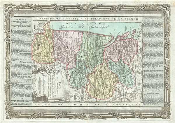
This is a beautiful 1790 map of the Aquitaine and part of the Poitou-Charentes regions of France by the French cartographer Louis Brion de la Tour. Oriented with north to the right, it covers the French departments of Charente, Charente-Maritime, Gironde, Landes, Dordogne, Lot-et-Garonne, Landes, and Basses-Pyrenees or Pyrenees-Atlantiques. The city of Bordeaux is identified. Color coding divides the map according to region and notes numerous towns, cities, rivers, forests, mountains and other topographical features.
The Bordeaux region is the seat of the Bordeaux wine region and produces many of the world's finest reds. The ancient county of Perigord (An important battlefield of the Hundred Years' War between the English and the French), roughly corresponds to the modern department of Dordogne. This area is best known for its production of Monbazillac, a sweet white wine, and Cabecou, a soft goat cheese. The coastal department of Gironde is known for its remarkable cuisine and is the home to both Fois Gras and Armagnac. Lot-et-Garonne is famous for its production of Buzet wines and Cabecou d'Antan, small round goat cheese with a fine, creamy texture. The Pilgrimage to Santiago de Compostella also passes through the northern part of this region. Landes produces Chalossais, a white cow cheese with a gentle, acidic edge. Tursan wine is also distilled here, along with Armagnac brandy.
The departments of Charente and Charente-Maritime, part of the Poitou-Charentes region which hugs the Loire Valley, is also famed for is beautiful Chateaux and for producing some of the world's finest wines. The department of Charente is known for its fine Cognacs and Pineau wines, agriculture, and cheese. It produces a wide variety of goat cheeses, such as Chabichou, Mothais, Buche du Poitou, and Chabi. In fact, it produces a third of all the goat cheese in France. Charente-Maritime is a coastal province bordering Charente, Dordogne, and Gironde (Bordeaux) is also known as the producer of the world's finest Cognacs.
> A beautifully engraved title cartouche adorns the bottom left quadrant of the map. To the left and right of the map are paste downs of French text with remarks and description of the map. Surrounding the whole is an elaborate decorative border featuring floral arrangements. This map was issued as plate no. 19 in Desnos’ Atlas National de France, bound with the most deluxe edition of his 1786 Atlas General Methodique et Elementaire, Pour l’Etude de la Geographie et de l’Histoire Moderne.
CartographerS
Louis Brion de la Tour (1743 - 1803) was the Cartographer Royal to the King of France, his official title being Ingenieur-Geographe du Roi. Despite a prolific cartographic career and several important atlases to his name, little is actually known of his life and career. He may have been born in Bordeaux. His son of the same name was born in 1763 and published until his death in 1832. It is nearly impossible to distinguish the work of the father from the work of the son, as both used the same imprint and were active in roughly the same period. Much of their work was published in partnership Louis Charles Desnos (fl. 1750 - 1790). Their most notable work is generally regarded to be his 1766 Atlas General. More by this mapmaker...
Louis Charles Desnos (1725 - April 18, 1805) was an important 18th century instrument maker, cartographer and globe maker based in Paris, France. Desnos was born in Pont-Sainte-Maxence, Oise, France, the son of a cloth merchant. From April of 1745 he apprenticed at a metal foundry. Desnos married the widow of Nicolas Hardy, sone of the map, globe, and instrument seller Jacques Hardy. Desnos held the coveted position of Royal Globemaker to the King of Denmark, Christian VII, for which he received a stipend of 500 Livres annually. In return Desnos sent the King roughly 200 Livres worth of maps, books and atlases each year. As a publisher, Desnos produced a substantial corpus of work and is often associated with Zannoni and Louis Brion de la Tour (1756-1823). Despite or perhaps because of the sheer quantity of maps Desnos published he acquired a poor reputation among serious cartographic experts, who considered him undiscerning and unscrupulous regarding what he would and would not publish. Desnos consequently had a long history of legal battles with other Parisian cartographers and publishers of the period. It is said that he published everything set before him without regard to accuracy, veracity, or copyright law. Desnos maintained offices on Rue St. Jacques, Paris. Learn More...
Source
Desnos, Louis-Charles, Atlas General Methodique et Elementaire, Pour l’Etude de la Geographie et de l’Histoire Moderne, 1786.
The Atlas general, civil, ecclesiastique et militaire, methodique et elementaire was issued by Louis Brion de la Tour (1756-1823) and Louis Charles Desnos (1725-1805) from about 1764 with subsequent reissued until about 1790. It was intended for use by the 'young nobles of the Ecole Royale Militaire,' but also proved popular with general audiences. The atlas was compiled using an uncommon printing method involving multiple pressings as well as paste downs for each page. Typically maps from the atlas feature an elaborate rococo decorative border containing a smaller map of approximately 10 x 14 inches, a title at the top and bottom of each page, and descriptive text, generally either a pastedown or separate printing to either side of the map. This unusual combination of printings and pastedowns allowed the publisher maximum flexibility and thus it is not uncommon to find variants of this atlas both with and without the decorative borer, with and without the descriptive pastedowns, pastedowns in different languages, and with changing titles for individual maps. There are various different collations for this atlas depending upon where it was intended to be sold. For example, versions sold in the United States and England replace the large map of France with new maps of the United States. It was not uncommonly bound with de la Tour's Atlas National de France.
Very good. Minor wear along original centerfold. Minor foxing.
OCLC: 956287391.