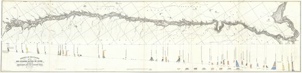
This is a beautiful 1852 geological map of the Des Moines river in Iowa by D. D. Owen. It covers the flow of the Des Moines River, a tributary of the Mississippi, between the Mississippi and the Raccoon Fork (roughly from Nauvoo in illinois to Des Moines) and notes the rock and soil composition throughout. The map also notes cities, towns, canals, dams and other details. A color coded geological cross-section in included in the bottom half of the map, with a key along the bottom right border. This map was published by Lippincott, Grambo and Company to accompany the 1852 Report of a Geological Survey of Wisconsin, Iowa and Minnesota; and incidentally of a Portion of Nebraska Territory.
Source
Lippincott, Grambo and Co., Report of a Geological Survey of Wisconsin, Iowa and Minnesota; and incidentally of a Portion of Nebraska Territory, (Philadelphia) 1852.
Very good. Minor wear and toning along original fold lines. Minor spotting. Minor damage near left margin.
Rumsey 690.043.