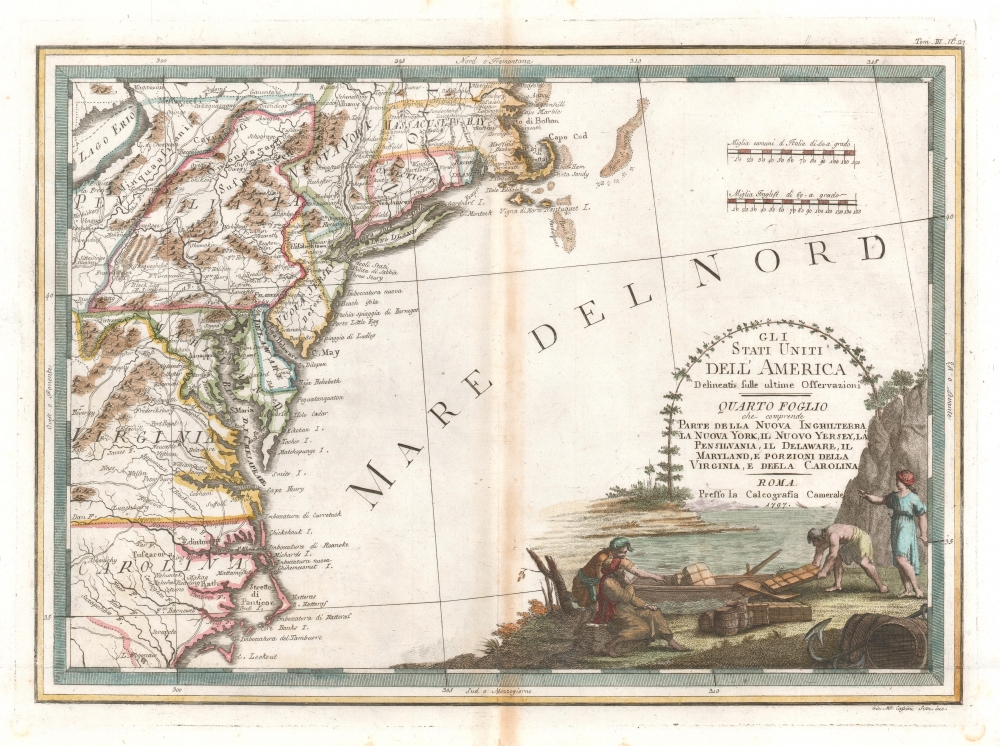
A very nice example of Cassini's stunning 1797 map of the Eastern seaboard of the United States. The map covers from Massachusetts to Cape Lookout and inland as far as Lake Erie and western Maryland. Some of the banks and shoals of Cape Cod and Nantucket are noted. Of interest is Cassini's support for Pennsylvania's claims to the Upper Wyoming Valley. This area was hotly contested between Pennsylvania and Connecticut rom about 17769, resulting in a series of conflicts known as the Yankee-Pennamite Wars (1769 – 1784). The issue was not resolved until after the American Revolution, when the 1799 Continental Congress decided in favor of Pennsylvania.
Cartographically Cassini derived this map from the 1778 Zatta 12 sheet revision and expansions of the John Mitchell's seminal 1755 map of the eastern part of North America. Cassini published six maps of United States regions based upon Zatta's work, of which this is map no. 4. This work was published in Cassini's 1797 Nuovo Atlante Geografico Universale. Today all maps from this series are highly sought after for their exceptional beauty and fine engraving.
Cartographer
Giovanni Maria Cassini (1745 - 1824) was a Rome based Italian mathematician, globe maker, geographer, engraver, and cartographer active in the later part of the 18th and early 19th century. He was a disciple of Giovanni Battista Piranesi. He invented new form of projection used for an atlas of the kingdom of Naples issued by Giovanni Antonio Rizzi Zannoni. Cassini is best known as a globe maker and is considered the last of the great 18th century globe makers. His maps are distinctive for their fine engraving, dark strong impressions, and elaborate distinctive cartouche work. Unlike many map and atlas publishers of the period, Cassini did all of his own engraving work - this impregnating each map with his unmistakable style. Though he produced a significant corpus of well-regarded work, little is known of Cassini's personal life. G. M. Cassini is often mistakenly associated with the well-known French cartographic family of the same name, however, they are not related. More by this mapmaker...
Source
Cassini, G. M., Nuovo Atlante Geografico Universale, (Roma : Presso la Calcografia Camerale) 1797.
Giovanni Maria Cassini's Nuovo Atlante Geografico Universale was published between 1792 and 1801. The atlas consisted of three volumes, published in 1792, 1797, and 1801, respectively. The first volume was dedicated to 24 globe gores, 12 terrestrial gores and 12 celestial gores, printed in three gore sections, which could be demounted from the atlas and, following Cassini's provided instructions, constructed into a globe. The terrestrial globe is based upon Captain James Cook's voyages, the last of which aboard the HMS Resolution was completed in 1779. The celestial globe makes use of the research of John Flamsteed (1646-1719) and Nicolas Louis de Lacaille (1713-1762). The second and third volumes contains geographical maps. The second volume in particular, features important maps of America and Asia. Cassini published this atlas in Rome.
Very Good. Minor centerfold wear and toning. Wide margins. Blank on verso. Platemark visible.
OCLC 944184977. McCorkle, B. B, New England in Early Printed Maps 1513 - 1800, 797.3.