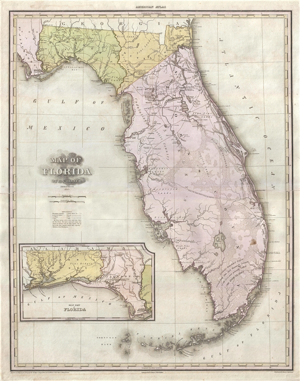
A fine example of H. S. Tanner's monumental 1825 map of Florida. This is one of the earliest obtainable maps of Florida Territory. The map covers peninsular Florida to the St. Mary River which forms the Georgia border and west as far as Jackson County. An inset in the lower left extends the map westward to include Escambia County to the Perdido River. The map identifies European settlements as well as American Indian Villages (appearing as little triangles or teepees). It also features richly detailed topography throughout identifying, roads, hills, swamps, and lakes. Miami, of course, is not present, but the Cape Florida Settlement, roughly in the same location, is identified.
The map identifies a number of layovers from the old Spanish land grant program, including the Fernando da ma Maza Arredondo Grant (Near Vacasansa Bay), Pedro Miranda's Grant (near Tampa), Fernando M. Arredondo Jr.'s Grant (on the Coolasahatchie River), Fleming's Grant (on the San Sebastian River), and Joseph Delespines' Grant (near Titusville and Cape Canaveral). With incredible difficulty and protest, the land grants were dissolved when Florida became part of the United States.
One of the more interesting Grants is the Moses Elias Levy land appearing west of Jacksonville on Alligator Creek. Levy was a Sephardic Jew, Proto-Zionist, Abolitionist, and American Jewish pioneer who emigrated to the United States form Mogador, Morocco. Not a proper grant, in 1819 Levy purchased the land from his friend, the Spanish grantee, Alejandro Ramierz. It consisted of 53,000 acres on which Levy planted to establish a proto-Zionest 'New Jerusalem.' At the time Jews were still active persecuted in Europe, but not in the United States where they could enjoy rights as full citizens. He imagined his settlement, called the Pilgrimage Plantation, as a utopian haven where European could escape anti-Semitism in a Moshav-like social and political setting. Unfortunately lacking the vast capital required to develop the land, the settlement never really took off. By 1828, only 21 Jews settled on Levy’s land and the notion of exclusively Jewish settlement was abandoned. Moreover, since Levy's properties presupposed the United States recognition of Spanish land grants, which it opposed, Levy was financially ruined by a lengthy, and ultimately fruitless, court battle.
Cartographically the map is based upon Charles Vignole's map of 1823. Tanner first published this map in 1823. The present example is the scarce 2nd edition from 1825, in which the map has been updated with the addition of Gadsden County (only St. Johns, Duval, Jackson and Escambia counties are shown in the 1823 edition). This map was published in the 1825 edition of Tanner's iconic New American Atlas.
Cartographer
Henry Schenck Tanner (1786 - May 18, 1858) was one of the preeminent American map engravers and publishers of the early 19th century - what is considered to be the "Golden Age of American Map Publishing". Born in New York City but based in Philadelphia, Tanner's forty plus year career was almost entirely focused on cartographic work. His earliest map work appears in conjunction with another important map publisher, John Melish. Early in his career, Tanner partnered with his brother Benjamin, to engrave extensively for Melish as well as other Philadelphia publishers including Lucas Fielding (Baltimore), A. Bourne, Jason Torey, Samuel Harrison, and Samuel Lewis, among others. In 1818 Tanner convinced his fellow publishers and partners to finance the compilation of a New American Atlas. The atlas was sold by subscription and slowly emerged between 1819 and 1823. The New American Atlas, possibly the pinnacle of 19th century American cartography and was commended in its day as "one of the most splendid works of the kind ever executed in this country". It was subsequently republished in several updated editions until about 1839. Tanner had by this time become the most active and influential map publisher in the United States. Around 1832, recognizing the market for a less cost prohibitive atlas, Tanner began work on the smaller format New Universal Atlas. This popular and important atlas went through numerous editions before being bought out by Carey and Hart, and then, in 1846, by S. A. Mitchell, who would rise to become the preeminent publisher of the next generation. In addition to these important atlases, Tanner also issued numerous extremely important and influential travelers guides, state maps, wall maps, and pocket maps. He should not be confused with his brother, also an America map engraver, the New Yorker Benjamin Tanner. More by this mapmaker...
Source
Tanner, H. S.,
A New American Atlas, (Philadelphia: Tanner) 1825.
Tanner's
New American Atlas is regarding as the largest and most beautiful early American atlas, truly a landmark achievement from the Golden Age of American Cartography. The atlas was initially published in five parts between 1819 and 1823, after which collected editions were issued in 1823, 1825, 1833, and 1839. It terms of size, format, printing quality, paper quality, cartographic accuracy, and elegance of engraving, the
New American Atlas was unparalleled. As noted by map historian Walter Ristow, 'Tanner's atlas raised U.S. commercial map production to a new level of excellence.' His contemporaries were also duly impressed. The American educator and historian Jared Sparks, as quoted by Ristow, describes the atlas as thus:
on the whole as an American Atlas, we believe Mr. Tanner’s work to hold a rank far above any other, which has been published. The authentic documents, to which he had access, the abundance of his materials, the apparent fidelity, with which they are compiled, the accurate construction of his maps, and the elegance with which they are executed, all these afford ample proofs of the high character of the work, of its usefulness as a means of extending the geographic knowledge of our own country, and of its claims to public patronage. (Ristow, p. 197)
Very good. Even overall toning. Some minor centerfold wear and verso reinforcement. Minor stains to margins. Spot in south Florida.
Rumsey 2755.018. Phillips (Atlases) 3669-18.