This copy is copyright protected.
Copyright © 2024 Geographicus Rare Antique Maps
1800 Stockdale Map or Plan of the City of Genoa, Italy
Genoa-stockdale-1800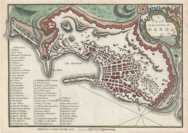

Well, Prince, so Genoa and Lucca are now just family estates of the Buonapartes.... And what do you think of this latest comedy, the coronation at Milan, the comedy of the people of Genoa and Lucca laying their petitions [to be annexed to France] before Monsieur Buonaparte, and Monsieur Buonaparte sitting on a throne and granting the petitions of the nations?Genoa would eventually become part of the Kingdom of Sardinia in 1815, following the defeat of Napoleon. This map was published by John Stockdale in 1800.
John Stockdale (March 25, 1750 - June 21, 1814) was an English book and map publisher active in London in the late 18th and early 19th centuries. Stockdale, born in Caldbeck, England, was trained by his father in the family trade of blacksmithing. Blacksmithing must not have been his cup of tea, for as soon as he was able, he left this trade in favor of a number of minor service positions, working at various times as a porter and a valet. One such position put him in the service of the bookseller John Almon. Having learnt the book trade by observing Almon, Stockdale opened his own bookshop and began publishing various historic and scientific works. Fellow publishers, perhaps reacting to his social status at birth, wrote of him, "being a man of natural parts, he soon became conspicuous in business in spite of much eccentricity of conduct and great coarseness of manners." Never quite accepted in the trade, Stockdale's fellow London publishers derogatorily referred to him as "The Bookselling Blacksmith". Nonetheless, Stockdale had a number of important works to his name, including several geographies, most notably the 1794American Geography 1794 and, with John Cary, the 1805 New British Atlas. More by this mapmaker...
Copyright © 2024 Geographicus Rare Antique Maps | Geographicus Rare Antique Maps
This copy is copyright protected.
Copyright © 2024 Geographicus Rare Antique Maps