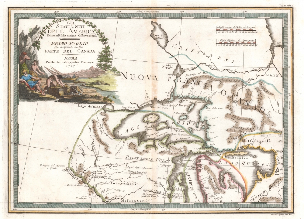
A spectacular 1797 Giovanni Maria Cassini map of the Western Great Lakes and the surrounding regions. Centered on Lake Superior, the map covers from the Mississippi River to the eastern limits of Lake Huron and from an apocryphal lake, Cristinesi, to the central part of Lake Michigan, roughly in the vicinity of modern day Milwaukee. The Post-Revolutionary War borders of the United States and Canada are noted. Being a somewhat large scale production, the map offers excellent information, including the deportment of American Indian tribes and villages. A highly decorative title cartouche appears in the upper left quadrant and features fishermen.
The four fictional islands in Lake Superior are present. Laid down by Jacques-Nicholas Bellin in his influential 1744 map, these apocryphal islands include: Philippeux, Pontchartrain, Maurepas, and St. Anne. They were invented three years earlier by the French historian and traveler Charlevoix, then subsequently immortalized by his cartographer Jacques-Nicholas Bellin. The islands were intended to honor Charlevoix' s personal patron, the Count of Maurepas, Jean-Frederic Phelypeaux. The largest of the three islands, Philippeaux, is named directly after the count. The second largest island, Pontchartrain, refers to Phelypeaux's family estate. The third island, which may in fact be a mismapping of the factual State Islands, is named after the count's seat, Maurepas. The fourth and smallest of the islands, St. Anne, references the count's patron saint. Charlevoix described the islands as being rich in minerals leading numerous explorers to search for them in vain. Bellin dutifully introduced the four islands to his map, and such was his influence that they were subsequently copied by most subsequent cartographers, including John Mitchell in his seminal 1755 wall map of North America. The highly regarded Mitchell map was used in negotiating the 1783 Treaty of Paris that formally concluded the American Revolutionary War. Therein, the apocryphal Philippeaux was assigned as a marker for the new United States - British America border thus setting the stage for later political strife.
Cartographically Cassini derived this map from the 1778 Zatta 12 sheet revision and expansions of the John Mitchell's seminal 1755 map of the eastern part of North America. Cassini published six maps of United States regions based upon Zatta's work, of which this is map no. 1. This work was published in Cassini's 1797 Nuovo Atlante Geografico Universale. Today all maps from this series are highly sought after for their exceptional beauty and fine engraving.
Cartographer
Giovanni Maria Cassini (1745 - 1824) was a Rome based Italian mathematician, globe maker, geographer, engraver, and cartographer active in the later part of the 18th and early 19th century. He was a disciple of Giovanni Battista Piranesi. He invented new form of projection used for an atlas of the kingdom of Naples issued by Giovanni Antonio Rizzi Zannoni. Cassini is best known as a globe maker and is considered the last of the great 18th century globe makers. His maps are distinctive for their fine engraving, dark strong impressions, and elaborate distinctive cartouche work. Unlike many map and atlas publishers of the period, Cassini did all of his own engraving work - this impregnating each map with his unmistakable style. Though he produced a significant corpus of well-regarded work, little is known of Cassini's personal life. G. M. Cassini is often mistakenly associated with the well-known French cartographic family of the same name, however, they are not related. More by this mapmaker...
Source
Cassini, G. M., Nuovo Atlante Geografico Universale, (Roma : Presso la Calcografia Camerale) 1797.
Giovanni Maria Cassini's Nuovo Atlante Geografico Universale was published between 1792 and 1801. The atlas consisted of three volumes, published in 1792, 1797, and 1801, respectively. The first volume was dedicated to 24 globe gores, 12 terrestrial gores and 12 celestial gores, printed in three gore sections, which could be demounted from the atlas and, following Cassini's provided instructions, constructed into a globe. The terrestrial globe is based upon Captain James Cook's voyages, the last of which aboard the HMS Resolution was completed in 1779. The celestial globe makes use of the research of John Flamsteed (1646-1719) and Nicolas Louis de Lacaille (1713-1762). The second and third volumes contains geographical maps. The second volume in particular, features important maps of America and Asia. Cassini published this atlas in Rome.
Very good. Minor centerfold wear and toning. Wide margins. Blank on verso. Platemark visible.
OCLC 944184424. McCorkle, B. B, New England in Early Printed Maps 1513 - 1800, 797.3.