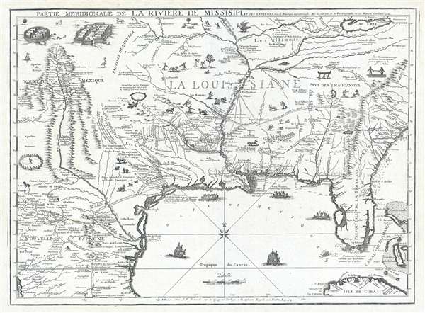
Title
Partie Meridionale De La Riviere De Missisipi, et ses Environs dan L'Amerique Septentrionale.
1718 (dated)
18.5 x 26 in (46.99 x 66.04 cm)
1 : 3800000
Description
A seminal map of the utmost importance and rarity, this is Nicolas de Fer's 1718 map of the Mississippi River Valley drawn to promote the Compagnie d'Occident. Essentially mirroring the coverage of De L'Isle's map of 1703, the map covers from just west of the Rio Grande (Rio del Norte) eastward as far as Charleston, north to include Lake Erie, and south as far as Cuba and the Gulf of Mexico. Per its title, the map is centered on the Mississippi Valley and was intended to illustrate the lush richness of this region.
This map is a separate issue of the south-west sheet of a four-sheet map commissioned by John Law and his Compagnie d'Occident (Mississippi Company). The Compagnie d'Occident was a French joint stock company founded by Law to develop and commercialize the French dominated Mississippi Valley. Like similar contemporaneous joint stock companies, such as England's South Sea Company, the enterprise attracted enormous initial interest and investment despite accomplishing little of substance. Instead of developing the Mississippi Valley, as promised, the company's directors, led by Law, focused on attracting more and more investment to keep its stock at a premium and stay afloat – much like the modern-day Ponzi scheme. As part of this scheme, Law commissioned De Fer to prepare a new map to promote the richness and potential of the company's monopoly in French Louisiana and the Mississippi Valley.
The first edition of this map appeared in 1715 and is very rare today, with only a couple of known surviving examples. This difference between that edition, and this, its 1718 Compagnie d'Occident successor, is striking. This 1718 map is a far more lavish production, with numerous cartographic updates, particularly in the west, and the addition of a plethora of vignettes, including livestock, indigenous people, and other fauna intended to illustrate the region's wealth. The cartographic changes too, are notable. De Fer renames Florida from Presque Isle de la Florida to Presque Isle de la Louisiane, bringing it firmly within the prevue of the Compagnie d'Occident's monopoly. There is also a considerable geographical advancement in the lands to the west of the Mississippi, most of which is derived from the explorations of the French Jesuit Missionary Francoise Le Maire. Numerous American Indian communities have been added, often with annotations identifying them as allies or enemies of the Spanish – presumably with the assumption that enemies of the Spanish might be friendly to the French. There are also numerous additional annotations throughout associated with the discoveries of René-Robert Cavelier, Sieur de La Salle (1643 – 1687) between 1673 and 1687, again, clearly with the intent of boosting French claims and exaggerating extent French activity in the region. Additionally, a network of roadways, presented as seemingly great highways, stretch from Charleston to Fort Proudhome on the Mississippi, to La Salle's failed colony of Fort Saint Louis (on Garcitas Creek, near present-day Victoria, Texas) to Valladolid and Queretaro, Mexico. Truly, De Fer's Mississippi Valley appears a land ripe with potential.
In addition to this map's association with John Law and the Compagnie d'Occident, it is also the first published map to incorporate the discoveries of Françoise Le Maire. The results of Le Maire's discoveries appeared in France in 1716, in the form of a manuscript map currently held in the archives of the Bibliothèque Nationale de France. De Fer's map predates Guillaume De L'Isle's map of the same region, published later in the same year, by several months. This map also served as the source material John Mitchell's significant 1755 wall map of North America.
This map was separately published but often added to earlier De Fer atlases post-publication. It also occasionally appears in composite atlases by De Fer and others. It was published by J. F. Benard, of Quai de l'Horloge, Paris.
Cartographer
Nicholas de Fer (1646 - October 25, 1720) was a French cartographer and publisher, the son of cartographer Antoine de Fer. He apprenticed with the Paris engraver Louis Spirinx, producing his first map, of the Canal du Midi, at 23. When his father died in June of 1673 he took over the family engraving business and established himself on Quai de L'Horloge, Paris, as an engraver, cartographer, and map publisher. De Fer was a prolific cartographer with over 600 maps and atlases to his credit. De Fer's work, though replete with geographical errors, earned a large following because of its considerable decorative appeal. In the late 17th century, De Fer's fame culminated in his appointment as Geographe de le Dauphin, a position that offered him unprecedented access to the most up to date cartographic information. This was a partner position to another simultaneously held by the more scientific geographer Guillaume De L'Isle, Premier Geograph de Roi. Despite very different cartographic approaches, De L'Isle and De Fer seem to have stepped carefully around one another and were rarely publicly at odds. Upon his death of old age in 1720, Nicolas was succeeded by two of his sons-in-law, who also happened to be brothers, Guillaume Danet (who had married his daughter Marguerite-Geneviève De Fer), and Jacques-François Bénard (Besnard) Danet (husband of Marie-Anne De Fer), and their heirs, who continued to publish under the De Fer imprint until about 1760. It is of note that part of the De Fer legacy also passed to the engraver Remi Rircher, who married De Fer's third daughter, but Richer had little interest in the business and sold his share to the Danet brothers in 1721. More by this mapmaker...
Condition
Very good. Original platemark. Blank on verso.
References
Rumsey 10022.099. Cumming, W., The Southeast in Early Maps, #169. Lowery, W., The Lowery Collection, #286.