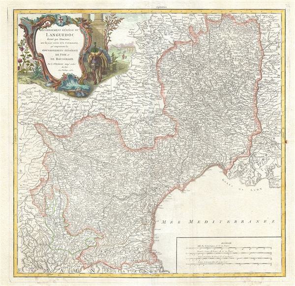
This is a beautiful 1752 map of the Languedoc region of France by Robert de Vaugondy. It covers the southeastern portions of France including the whole or parts of the departments of Pyrenees-Orientales, Herault, Tarn, Tarn-et-Garonne, Aveyron, Lozere, Gard, Bouches-du-Rhone, Ardeche, Haute-Loire, Cantal, Aude, Ariege and Haute-Garonne. The map extends from Urgel in Spain north to Brioude and from Lombez east as far as Martigues and the Mediterranean Sea. The map renders the entire region in extraordinary detail offering both topographical and political information with forests and mountains beautifully rendered in profile.
The Languedoc wine-growing region area is home to a wide variety of vineyards and is the oldest and largest in France. The department of Aude is famous for its wide variety of vineyards and wine production. In the east are the wines of Corbieres and la Clape, in the center are Minervois and Cotes de Malpeyre, and in the south, blanquette de Limoux. A wide variety of wines come out of the Pyrenees-Orientales region, including the famous Muscat wine. This wine can be tasted as an aperitif or with dessert. It pairs especially well with Roquefort cheeses. The red wines produced in the Herault region are meaty, tannic wines with a deep red color. The area is also known for its production of Pelardon cheese, made from goat's milk, and Perail, a ewe's milk cheese. Tarn produces a variety of traditional wines, including Cahors, Mauzac, Loin de l’Oeil and Ondenc for the white varieties and Braucol, Duras and Prunelart for the reds, while Tarn-et-Garonne, produces a number of quality wines, such as AOC Fronton, Cotes de Brulhois, and the Vins de Pays des Coteaux et Terrasses de Montauban. Tarn-et-Garonne is also home to the area of Coteaux du Quercy, which has a reputation for producing supple and full-bodied wines. The city of Moissac is known for its fine desert grapes. This region is also a historic stopping point on the Pilgrimage to Santiago de Compostella.
The remote mountainous part of Languedoc is rural, sparsely populated, and extremely beautiful. Lozere is famous for its cheese production. Their Roquefort, 'Bleu des Causses', and Tomme de Lozere varieties, for instance, are world-renowned. Aveyron, centered on Rodez, is famous for its production of Roquefort, a flavorful ewe's milk blue cheese. This region is also known for the legendary Bete du Gevaudan, a terrible man-wolf who terrorizes the countryside.
The map includes a beautifully engraved title cartouche in the top left quadrant. This map was drawn by Robert de Vaugondy in 1752 and published in the 1757 issue of his Atlas Universal.
Cartographer
Gilles (1688 - 1766) and Didier (c. 1723 - 1786) Robert de Vaugondy were map publishers, engravers, and cartographers active in Paris during the mid-18th century. The father and son team were the inheritors to the important Sanson cartographic firm whose stock supplied much of their initial material. Graduating from Sanson's map's Gilles, and more particularly Didier, began to produce their own substantial corpus of work. Vaugondys were well respected for the detail and accuracy of their maps in which they made excellent use of the considerable resources available in 18th century Paris to produce the most accurate and fantasy-free maps possible. The Vaugondys compiled each map based upon their own superior geographic knowledge, scholarly research, the journals of contemporary explorers and missionaries, and direct astronomical observation - moreover, unlike many cartographers of this period, they commonly took pains to reference their source material. Nevertheless, even in 18th century Paris geographical knowledge was severely limited - especially regarding those unexplored portions of the world, including the poles, the Pacific northwest of America, and the interior of Africa and South America. In these areas the Vaugondys, like their rivals De L'Isle and Buache, must be considered speculative geographers. Speculative geography was a genre of mapmaking that evolved in Europe, particularly Paris, in the middle to late 18th century. Cartographers in this genre would fill in unknown areas on their maps with speculations based upon their vast knowledge of cartography, personal geographical theories, and often dubious primary source material gathered by explorers and navigators. This approach, which attempted to use the known to validate the unknown, naturally engendered many rivalries. Vaugondy's feuds with other cartographers, most specifically Phillipe Buache, resulted in numerous conflicting papers being presented before the Academie des Sciences, of which both were members. The era of speculatively cartography effectively ended with the late 18th century explorations of Captain Cook, Jean Francois de Galaup de La Perouse, and George Vancouver. After Didier died, his maps were acquired by Jean-Baptiste Fortin who in 1787 sold them to Charles-François Delamarche (1740 - 1817). While Delamarche prospered from the Vaugondy maps, he also defrauded Vaugondy's window Marie Louise Rosalie Dangy of her inheritance and may even have killed her. More by this mapmaker...
Source
Vaugondy, R., Atlas Universel (Paris) 1757.
The Atlas Universel was the crowning glory of the Robert de Vaugondy firm's atlas production. The atlas was revolutionary on many levels and exemplified the Vaugondy creedo commode, complet, univorme, et suive (convenient, complete, uniform, and easy to use). The atlas thus consisted of a wide corpus of maps, both modern and historical, was of moderate height and width, and featured maps of uniform style and structure. They partnered with Antoine Boudet, a shrewd businessman and publisher with whom they had worked previously, to produce the first edition. To minimize his fiscal risk, Boudet sold the atlas first by subscription using a large prospectus, receiving in the process over 1100 pre-orders. The first edition appeared in 1757 and contained beautifully produced maps with elaborate freshly designed allegorical cartouche work, generally by Pierre-Edme Babel, Pierre Philippe Choffard, and Charles Nicholas Cochin. Most of the maps were engraved by the Delahaye firm, the payment for whose services ultimately led to legal disputes. Despite proving a popular work of astounding quality, the Atlas Universal received harsh criticism from fellow cartographers, particularly Philipppe Buache. Ever at odds with the Vaugondys, Buache's critical perspective may have been influenced more by political maneuvering than academic affront. The atlas was issued in multiple editions between 1757 and 1788. Later editions, issued after 1786, were taken over by Charles Delamarche, who inherited the Robert de Vaugondy firm and assumed Boudet's publication rights.
Very good. Minor wear and creasing along original centerfold. Original platemark visible. Some spotting and offsetting with water stains near borders. Overall age toning.
Rumsey 3353.045. Pedley, Mary Sponberg Belle et Utile: The Work of the Robert de Vaugondy Family of Mapmakers, 155.