Title
Mappe-Monde ou Description du Globe Terrestre, Assujettie aux Observations Astronomiques.
1762 (dated)
12 x 18 in (30.48 x 45.72 cm)
1 : 110000000
Description
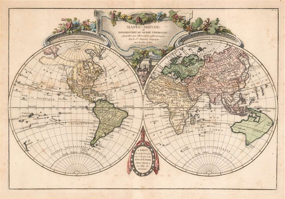
A beautiful and impressive map of the world drawn by Jean Janvier in 1762. Depicts the entire world on a double hemisphere projection framed by elaborate baroque cartouche work.
North America, particularly the Northwestern quadrants, are exceptionally interesting and speculative. A magnificent inland sea, called the Sea of the West or in this case the Mer de L'Ouest, is presented in the northwestern part of the America. This body of water, alternatively called the Sea of the West or Baye de l'Ouest, was speculated by Philippe Buache and De l'Isle in the early 18th century based upon wishful thinking, American Indian stories, and the somewhat questionable 16th century explorations of Juan de Fuca. Here Janvier gives the Mer de l'Ouest its fullest expression, though he specifically does not connect it to either the factual network of lakes and rivers extending westward from the Hudson Bay or to the speculative De Fonte network just to the north.
This is also one of the few maps to include the speculative 'Muller Peninsula.' Postulated by the German geographer Gerhard Friedrich Muller, the Muller Peninsula follows the Aleutian Islands roughly in the form of modern day Alaska. Subsequent Navigations by Cook and others would soon disprove the peninsula theory.
By contrast the northeast parts of Asia, which had recently been explored by Vitus Bering and Tschirikow, are depicted with a fair approximation of accuracy. Terre de Gama and Terre de la Company, speculative mis-mappings of the Japanese Kuril Islands by the 17th century Dutch explorers Maerten de Vries and Cornelis Jansz Coen , appear just northeast of Yedso (Hokkaido). Gama or Compagnie remained on maps for about 50 years following Bering's voyages until the explorations of Cook confirmed the Bering findings.
South of the equator the shores of Australia or New Holland are speculatively mapped with a dotted line defining the southern and eastern portions continent. Van Diemen's Land or Tasmania is attached to the mainland, which itself includes New Guinea and parts of the New Hebrides, identified here as Terre de S. Espirit. Terre du St. Espirit, in fact the New Hebrides was mis-mapped by the near insane 17th century Portuguese navigator Pedro Fernandes de Queiros who proclaimed that he had discovered the Great Southern Continent, or Terre Australis. Not to be confused with modern day Australia, Terre Australis was a vast speculative continent that supposedly covered much of the southern hemisphere in Aristotelian symmetry with the bulk of Asia in the Northern Hemisphere. Although by this time most cartographers had stopped mapping Terre Australis, some, like Janvier, perhaps with the great myth in mind, wishfully increased Australia's dimensions.
Polynesia is mapped with numerous islands named, but few are the correct size or in the correct place. Hawaii, which had just been discovered by Cook, here makes its first appearance. What is shown is 'Terre de Davis' roughly where Easter Island is today. Terre de Davis or Davis' Land was supposedly discovered in 1688 by an English navigator of the same name. Many historians argue whether or not Davis Land was actually Easter Island, but it does seem likely.
In South America many of the speculative geographic elements common to earlier maps of the regions, such as el Dorado and Lake Parima, are absent though the Lago de Xarayes does remain. The Xarayes, a corruption of 'Xaraies' meaning 'Masters of the River,' were an indigenous people occupying what are today parts of Brazil's Matte Grosso and the Pantanal. When Spanish and Portuguese explorers first navigated up the Paraguay River, as always in search of el Dorado, they encountered the vast Pantanal flood plain at the height of its annual inundation. Understandably misinterpreting the flood plain as a gigantic inland sea, they named it after the local inhabitants, the Xaraies. The Laguna de los Xarayes almost immediately began to appear on early maps of the region and, at the same time, took on a legendary aspect as the gateway to the Amazon and the kingdom of el Dorado.
Africa, as usual, is mapped accurately along the coasts and speculatively in the interior. While numerous tribes, kingdoms, and desert caravan routes are noted, most of the interior is conjectural. The Nile follows the two lake pattern developed in the 15th century on Ptolemaic maps. The gold mining region near the Kingdom of Monomotapa are labeled. South Africa is noted as the home of the Cafrerie and Hottentots.
The great southern content, a kind of speculative proto-Antarctica common to many early maps, is entirely absent, though several Antarctic islands, including the Cap de la Circoncision (Bouvet's Island) and Lozier's B. de L'Oiseau are noted.
Both hemispheres are crowned with an elaborate decorative cartouche in the late baroque style. Drawn by Janvier as plate no. 1 in Jean Lattre's Atlas Moderne.
CartographerS
Jean Denis Janvier (fl. 1746 - 1776), sometime also known as 'Robert', was a Paris based cartographer active in the mid to late 18th century. Janvier signed his maps Signor Janvier. By the late 18th century, Janvier was awarded the title of 'Geographe Avec Privilege du Roi' and this designation appears on many of his later maps. Janvier worked with many of the most prominent French, English and Italian map publishers of his day, including Longchamps, Faden, Lattre, Bonne, Santini, Zannoni, Delamarche, and Desnos. More by this mapmaker...
Jean Lattré (170x - 178x) was a Paris based bookseller, engraver, globe maker, calligrapher, and map publisher active in the mid to late 18th century. Lattré published a large corpus of maps, globes, and atlases in conjunction with a number of other important French cartographic figures, including Janvier, Zannoni, Bonne and Delamarche. He is also known to have worked with other European cartographers such as William Faden of London and the Italian cartographer Santini. Map piracy and copyright violations were common in 18th century France. Paris court records indicate that Lattré brought charges against several other period map publishers, including fellow Frenchman Desnos and the Italian map engraver Zannoni, both of whom he accused of copying his work. Lattré likes trained his wife Madame Lattré (né Vérard), as an engraver, as a late 18th century trade card promotes the world of 'Lattré et son Epouse.' Lattré's offices and bookshop were located at 20 rue St. Jaques, Paris, France. Later in life he relocated to Bordeaux. Learn More...
Source
Lattre, Jean, Atlas Moderne ou Collection de Cartes sur Toutes les Parties du Globe Terrestre, c.1778.
Condition
Very good. Some toning and wear with minor verso repairs along original centerfold. Minor foxing. Original platemark visible.
References
Rumsey 2612.003. Phillips (Atlases) 664. Perry, Thomas Melville and Prescott, Dorothy F., A guide to Maps of Australia in Books Published 1780 - 1830: An Annotated Cartobibliography, 1762.01. National Maritime Museum, 215. British Library, World, col. 384-385 (1762-1785 editions). National Library of Australia, MAP RM 3232.